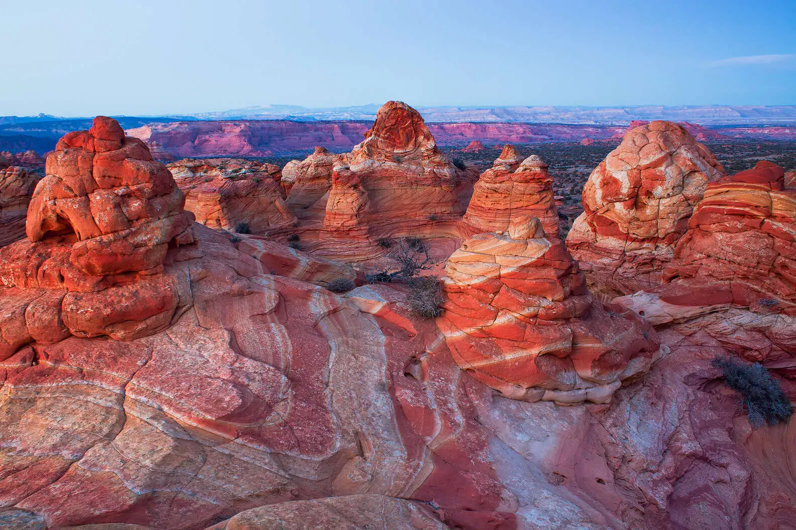
Vermilion Cliffs National Monument is a remote, 280,000-acre expanse in northern Arizona famed for The Wave and deep slot canyons. Access hinges almost entirely on a competitive permit lottery or high-clearance 4WD navigation into unmarked wilderness. There are zero entrance fees, no paved roads, and no services inside the monument, demanding total self-sufficiency.
My first drive into this part of the Arizona Strip ended with sand caked on my dashboard and a healthy dose of humility. I’m Chidi, part of the WakaAbuja team, and I have a habit of biting off more remoteness than planned. The Paria Plateau doesn’t care about your deadline, your sedan, or your phone battery.
This guide breaks down exactly how permits work, which trailheads actually lead to viewpoints, and why skipping White Pocket is a planning mistake I hope you avoid.
Jump to: The Wave Permit Guide | White Pocket | Trails & Slot Canyons | Photography Tips | Where to Stay | FAQ
Key takeaways
- The Wave lottery is extremely competitive. Most permits are won via the online advanced lottery; walk-in chances hover around 5% to 10% depending on the season.
- White Pocket requires zero permits. It delivers a landscape nearly as surreal as The Wave and is accessible only by high-clearance 4WD or guided tour.
- Cell service is effectively nonexistent. Download offline maps and GPS tracks on apps like Gaia GPS or Avenza before you leave Page or Kanab.
- The monument is a summer furnace. Daytime highs routinely exceed 105°F (40°C) from June through August. Heat stroke is a real threat.
- No amenities exist within monument boundaries. Carry all food, fuel, and at least one gallon of water per person per day.
- Navigation is hard. The Wave hike is unmarked. You navigate using BLM-provided photo guides, not trail signs.
- Condor viewing peaks in late spring. Look for them near the Vermilion Cliffs release site off Highway 89A.
How Does the Wave Permit Lottery Actually Work?
The Coyote Buttes North permit, which covers The Wave, is the most sought-after hiking pass in the United States. Only 64 people per day (or 16 groups, whichever limit is reached first) are allowed into the formation. I applied four times over two years before finally securing a spot in late March. Fatima, our Lagos-based researcher, got hers on her first online attempt. The results are deeply unpredictable.
The system splits into two distinct lotteries. The Advanced Lottery opens exactly four months before your intended hike date. You submit an application through Recreation.gov, pay a non-refundable fee, and wait. The Daily Lottery operates two days before your desired hike date. It’s geo-fenced; you must be within a specific geographic zone around Page, Arizona, or Kanab, Utah, to apply. I tried this twice from the parking lot of the Kanab BLM station. Cell reception barely cooperated. Both times, hundreds of people were applying for the same handful of unclaimed or canceled spots.
@treesahikes The Wave via Wirepass Trail in Vermillion Cliffs National Park at the border of Utah and Arizona. I applied back in November for the lottery to get a permit and I got it! It was so awesome to finally see it. #thewavearizona #vermillioncliffsnationalmonument #wirepasstrailhead
Chidi’s honest take: “Don’t build an entire road trip around winning the walk-in lottery. I watched three groups scrap their plans in the Kanab visitor center in one afternoon. Treat a Wave permit as a bonus, not your primary itinerary driver.”
Advanced Lottery Strategy
- Apply for midweek dates. Tuesdays and Wednesdays statistically have fewer group applications.
- Target winter months. December and January draw far fewer applicants than May. The sand is often dusted with snow, creating incredible contrast.
- Use small group sizes. A group of 2 has better odds than a group of 6, since the per-person permit cap fills fast.
- Apply monthly. Persistent applications are the single biggest factor in eventually winning.
Daily Lottery Hacks
- Arrive early at a reliable WiFi spot. The Kanab Center has strong public internet. Avoid the BLM office network, which slows under load.
- Have the Recreation.gov app installed and logged in. Seconds matter during the 9 a.m. to 10 a.m. application window.
- Check the geo-fence map carefully. It covers a generous area, but standing right on the edge of the boundary can cause GPS errors.
Permit fees change periodically. As of late this year, application fees hover around $9 per group, with an additional per-person recreation fee if you win. Always verify current prices on the official Recreation.gov Coyote Buttes North page.
Why Is White Pocket the Monument’s Best No-Permit Secret?
White Pocket sits in a detached section of the monument and falls under different BLM management rules. There is no daily visitor cap and no permit lottery. The formations consist of stark white and crimson polygonal sandstone layers twisted into shapes that look like melted brains. I spent six hours here without seeing another person. That isolation comes with a tradeoff: the access road is notoriously difficult.
The drive from House Rock Valley Road involves deep sand traps. I aired my tires down to 18 PSI and still nearly bogged down in a section locals call “the deep bowl. ” Fatima, who visited with a guide from Kanab, found the journey far less stressful. She booked a day trip through GetYourGuide and could focus entirely on photography instead of recovery tracks. If you lack extreme 4WD experience, a guided tour is the safest decision you can make.
@wideopen__spaces Alien landscapes/NO PERMIT REQUIRED. White Pocket is one of the most unique and most beautiful sites in Vermillion Cliffs. And unlike most spots in that area, you don’t need a permit to access it! You will, however, need a 4X4 high clearance vehicle to drive to White Pocket due to deep sand on the road as well as rocky areas. We rented a Jeep from a local company in Kanab, there are many to chose from! There are also plenty of tour companies in Kanab and Page that offer day trips to White Pocket if you don’t want to drive yourself. There’s no real trail here, it’s mostly open geological formations of crazy beautiful rock for 2 miles. Plan to spend about 2-3 hours walking around and exploring the area! There’s a photo op around every corner. Please note that cell service this far into Vermillion Cliffs National Monument is extremely unreliable. We didn’t have service for miles. Plan to bring lots of water and snacks. There are no bathrooms at the trailhead or anywhere on site. And remember to leave no trace! ❤️ #whitepocket #arizona #visitarizona #bucketlist #traveltiktok #tiktoktravel #Southwest #southernutah #hiking #hiketok #hikeutah #hikearizona #wanderlust #adventure #naturetiktok #desertadventures #outdooradventures #vermillioncliffs #hiketok #desert #deserthike
Fatima’s honest take: “White Pocket gave me 90% of the visual thrill of The Wave with zero bureaucratic headache. The texture in those rocks is so alien it made my camera sensor struggle. I’d return for sunset without hesitation.”
Overnight camping near White Pocket is allowed on BLM land. There are no facilities, so all waste must be packed out. Fire restrictions are common; check current rules on the BLM monument page before you travel.
Which Hikes Go Beyond The Wave? Buckskin Gulch and Paria Canyon
The monument contains the longest slot canyon in the contiguous United States: Buckskin Gulch. This 15-mile corridor narrows to less than 10 feet wide in places, with walls 500 feet tall blocking direct light for most of the day. I hiked the Wire Pass to Buckskin Gulch junction in mid-October. The rock was dry, and a stubborn pool of waist-deep, frigid water just past the confluence forced me to wade in boots that would squelch for the next three miles.
Paria Canyon offers the full backpacking alternative. A multi-day permit from the BLM is required for overnight trips, but day hikers can access the lower sections with far less red tape. Flash flood risk defines the safety calculus here. The watershed drains a vast area of southern Utah, and a storm 50 miles upstream can send a wall of water barreling through the narrows. I check the National Weather Service flash flood potential rating religiously before entering any slot canyon.
Wire Pass Trailhead
- Distance: 3.4 miles round-trip to the Buckskin junction.
- Terrain: Sandy wash leading to a narrow slot with a small rockfall scramble.
- Permit: Day-use fee paid at the trailhead, usually $6 per person as of last season. Check the signboard for current rates.
- Parking: Gravel lot manageable for most vehicles in dry conditions.
The Wave Trail
- Distance: 6.4 miles round-trip, unmarked.
- Navigation: Photo guidebook and GPS coordinates provided with your permit.
- Terrain: Deep sand, slickrock slabs, and one short but steep final ascent.
- Duration: 5 to 7 hours for most groups, allowing time for photography at the formation.
When Is the Best Light for Photographing the Wave?
The sandstone striations at The Wave shift color dramatically depending on sun angle. Midday light flattens the texture. I made this mistake on my first visit and returned with images that looked washed out. The sweet spot is the two hours after sunrise and the final 90 minutes before sunset. At those angles, the red and orange bands deepen, and cross-lighting throws the delicate erosion ridges into sharp relief.
A polarizing filter is non-negotiable. It cuts glare off the polished sandstone surfaces and saturates the sky without digital manipulation. I also carry a wide-angle lens, typically 16-35mm, for the main amphitheater and a telephoto zoom for isolating abstract sections of the canyon walls. Tripods are allowed with a standard permit. Drones are prohibited throughout the entire Vermilion Cliffs National Monument and neighboring Paria Canyon-Vermilion Cliffs Wilderness area. Rangers actively enforce this. I watched a ranger fine a visitor $200 near the Wire Pass trailhead for launching a small quadcopter. The rule is absolute.
What Is the Best Time of Year to Visit Vermilion Cliffs?
April through early June and late September through October provide the most reliable weather windows. Daytime highs in these windows sit between 70°F and 85°F (21°C to 29°C). Spring brings the added benefit of wildflowers scattered across the Paria Plateau, though winds can gust fiercely in April. I nearly lost a tent to a microburst near Stateline Campground one spring evening.
Summer is brutal and dangerous. The black cryptobiotic soil crust and dark sandstone absorb and radiate heat, creating ground temperatures that can exceed 130°F (54°C). Three hikers were rescued from the Coyote Buttes area in a single week this past July, according to the local sheriff’s office reports. Winter offers solitude and stark beauty. I hiked Buckskin Gulch in January with microspikes strapped to my boots. A thin skin of ice covered the deeper pools, and the reflected sound of cracking ice echoed strangely off the slot walls.
Chidi’s honest take: “October is the goldilocks window. Stable weather, warm enough rock for comfortable scrambling, and the permit applicant pool shrinks compared to spring break season. Book your Kanab lodging early, though — fall tourism is booming.”
Where Should I Stay When Visiting Vermilion Cliffs?
Inside the monument, only two primitive campgrounds exist: Stateline Campground and White House Campground. Both are first-come, first-served with pit toilets and zero potable water. White House sits at the Paria Canyon trailhead and fills quickly with backpackers. Stateline, perched on a windswept bench, offers sweeping views toward the Grand Staircase-Escalante. I woke up here to a sunrise that lit up the cliff face like a burning wall. The tradeoff is wind exposure and complete lack of shade.
Most travelers base themselves in Kanab, Utah (40 miles west) or Page, Arizona (40 miles east). Kanab functions as the practical gateway for the western trailheads and the BLM visitor center. Page offers larger hotel chains and proximity to Horseshoe Bend and Antelope Canyon. I recommend checking accommodation options on Booking.com for flexible cancellation policies and on Hotels.com if you collect loyalty rewards. For longer stays with a group, vacation rentals through Vrbo often beat hotel costs in Kanab.
The tiny outpost of Marble Canyon and the nearby Cliff Dwellers Lodge offer the closest lodging. The lodge sits roughly 15 minutes from the Wire Pass and White House trailheads. Gas is available here. Fill your tank. The next reliable fuel stop is an hour away. The restaurant at Cliff Dwellers serves a surprisingly good bison burger, and their ice machine runs 24 hours. I’ve relied on that ice machine to fill coolers before long desert drives on three separate occasions.
What Are the Real Dangers of Vermilion Cliffs?
The monument’s beauty masks an environment that punishes mistakes quickly. Flash floods kill people in the slot canyons. Heat stroke can incapacitate a hiker within hours on the exposed slickrock. Rescue services are slow. Cell signals do not exist. A personal locator beacon or satellite messenger like a Garmin inReach is the only reliable way to call for help. I carry one on every hike, even day trips.
Venomous animals are present but rarely a problem if you watch your step. Rattlesnakes sun themselves on warm rock in the morning. Scorpions hide under rocks and in dry creek beds. I almost placed my hand directly on a midget-faded rattlesnake while scrambling up a side drainage in Coyote Buttes South. It never rattled. The lesson: watch every handhold before you commit your weight to it. Check footwear before pulling boots on in the morning. Scorpions like dark, enclosed spaces.
How Do You Prepare for a Hike in Vermilion Cliffs?
Preparation here goes beyond a standard day-hike checklist. The BLM rangers I’ve spoken with at the Kanab station emphasize three non-negotiable items: a printed map, a GPS device with downloaded tracks, and a gallon of water per person. I pack a physical compass too, because GPS batteries die at the worst possible moment.
Gear Checklist Specific to This Monument
Sand gaiters prevent the fine red sand from filling your boots. I use a cheap pair of outdoor research-style gaiters and they’ve saved me from stopping every ten minutes to empty shoes. A sun umbrella or wide-brimmed hat with a neck flap provides mobile shade where none exists. Electrolyte powders added to water bottles stave off cramping far better than plain water alone. Footwear should be sturdy trail runners or lightweight boots with sticky rubber for slickrock grip. Heavy leather boots are overkill and blister-prone in the heat.
Vehicle Preparation
House Rock Valley Road is a graded dirt road that turns to impassable, sticky clay mud in rain. Even a 4WD truck can slide off the road into a ditch when the clay is wet. I check the road conditions with the Kanab BLM Field Office before driving. A full-size spare tire, tire repair kit, and a shovel are mandatory. I also carry a kinetic recovery rope. Getting stuck in deep sand without one means waiting hours for a tow truck that may not come.
What Are the Most Common Mistakes Visitors Make?
- Relying on phone GPS without offline maps. The trail to The Wave has zero cell signal. Navigation apps that require a data connection fail instantly. I’ve helped two lost parties find the return route by sharing my pre-downloaded track.
- Attempting the deep sand roads in a 2WD sedan. I’ve seen a Nissan Altima buried to its axles on the road to White Pocket. Recovery costs exceed $1,000. Rent a proper 4WD or book a guide.
- Underestimating water needs. One gallon (3.8 liters) per person per day is a minimum. In summer, I carry a gallon and a half. The dry air dehydrates you faster than you realize.
- Ignoring flash flood forecasts. A “marginal” flash flood risk still means a slot canyon can become a death trap. Cancel or reroute. The canyon will be there next time.
- Hiking without the BLM photo guide for The Wave. The route is unmarked. Landmarks look similar. The photo guide shows exactly which sandstone dome to navigate toward. Pick it up at the Kanab BLM office the day before your hike.
- Walking on cryptobiotic soil crust. These black, bumpy patches are living organisms that prevent erosion. They take decades to recover. Stay on established trails and slickrock.
- Assuming summer is the best season because it’s sunny. The heat is oppressive and dangerous. Two Arizona hikers died of hyperthermia in the wider monument area a few years ago. Late spring and early fall are safer and visually richer.
Where Can You See California Condors at Vermilion Cliffs?
The California condor recovery program releases captive-bred birds from a site perched high on the Vermilion Cliffs escarpment. The best public viewing spot is the pullout on Highway 89A near the Cliff Dwellers Lodge. I’ve had the most consistent sightings between March and July, when juvenile birds practice flight and return to the ledges to roost. Bring binoculars or a spotting scope. The birds often appear as dark specks against the red rock, and their 9.5-foot wingspan becomes unmistakable once they soar.
Morning hours, roughly 8 a.m. to 11 a.m., offer the best chance of seeing condors riding thermals up the cliff face. The Peregrine Fund and the Arizona Game and Fish Department manage the reintroduction. Their combined reports show the wild population in the Arizona-Utah region now exceeds 100 birds. Seeing one in flight over the same terrain where they nearly vanished is one of the great wildlife recovery stories of the American Southwest.
Frequently asked questions
Can you visit Vermilion Cliffs without a permit?
Yes. A permit is only required for Coyote Buttes North (The Wave), Coyote Buttes South, and overnight trips in Paria Canyon. Many areas, including White Pocket and the Wire Pass to Buckskin Gulch day hike, only require a day-use fee or are entirely free to access.
Is the hike to The Wave difficult?
The 6.4-mile round-trip hike is moderately strenuous due to deep sand, uneven slickrock, and total lack of shade or trail markers. The elevation gain is gentle, roughly 500 feet total, but navigation adds mental fatigue. Most fit hikers can complete it comfortably with an early start.
How far is Vermilion Cliffs from Las Vegas?
The drive from Las Vegas to the Wire Pass trailhead takes roughly 4.5 hours via I-15 and Highway 89 through St. George and Kanab. The South Rim of the Grand Canyon is about 2.5 hours south. Page, Arizona, is only 40 minutes east.
What happens if it rains during my hike?
Rain turns the access roads into impassable mud almost instantly. In slot canyons, rain upstream can trigger deadly flash floods with little warning. If rain is forecast, exit narrow canyons immediately and do not attempt to drive House Rock Valley Road until the surface has dried, which can take a full day.
Do I need a guide for The Wave or White Pocket?
A guide is not required for The Wave, but many people hire one for White Pocket to avoid the deep sand drive and navigate the unmarked jeep trails. Guided tours also handle permits and logistics for Coyote Buttes South hikes. Check offerings on TripAdvisor for operator reviews.
Is camping allowed inside the monument?
Dispersed camping is allowed in designated areas of the monument on BLM land. Two developed campgrounds, Stateline and White House, offer pit toilets but no water. Backpacking in Paria Canyon requires a separate overnight permit from the BLM.
Plan your trip: booking platforms we trust
The WakaAbuja team uses these platforms regularly because their cancellation policies tend to be clear, and their search filters help narrow down the specific amenities required for remote desert trips, like 4WD rental availability and last-minute lodging near trailheads.
GetYourGuide — Best for booking guided 4WD tours to White Pocket and South Coyote Buttes.
Vrbo — Our go-to for entire vacation homes near Kanab, especially for groups splitting costs.
Kayak — Useful for comparing flight prices into Las Vegas McCarran, the nearest major airport.
Expedia — Helpful for bundling a rental SUV with your flight to reduce overall trip cost.