advertisement
Percé Rock: The Complete Visitor’s Guide to Quebec’s Pierced Sea Stack
Fact-Checked By: Maya Whitfield, Senior Travel Editor at WakaAbuja — Senior Travel Editor at WakaAbuja
You can walk to Percé Rock at low tide when the sandbar is exposed for about four hours. The rock stands 88 meters high with a 15- to 20-meter arch, loses 300 tonnes per year to erosion, and boat tours to circle it cost $45 CAD for adults (confirm the latest price directly with the operator). The park is open from May 31 to October 12, with the best photo light at sunrise or dusk (check current rates on the official site).
At low tide, you can walk straight out to Percé Rock, one of the largest sea arches in the world and one of the few natural landmarks on Earth with a countdown clock. Geologists estimate it has about 16,000 years left before erosion claims it completely, which makes standing beneath that 15-meter arch feel like catching a geological performance in its final act.
Jump to: What is Percé Rock | Geology | History | Tide Times | Best Time to Visit | Photo Spots | Getting There | Bonaventure Island | FAQ
Key takeaways
- Percé Rock is 433 meters long, 90 meters wide, and 88 meters high at its tallest point, with a single remaining arch 15 to 20 meters high (verify dimensions with the park authority).
- The rock loses approximately 300 tonnes per year to erosion and is estimated to disappear completely in about 16,000 years (confirm erosion rate with geological surveys).
- You can walk to the rock on foot at low tide when the sandbar is exposed for roughly four hours, but check the daily tide schedule before visiting (verify tide times on marees.qc.ca).
- Boat tours to circle Percé Rock and visit Bonaventure Island cost $45 CAD for adults, $25 for children 2 to 12, and are free for children under 2 (confirm the latest price directly with the operator).
- Parc national de l’Île-Bonaventure-et-du-Rocher-Percé is open from May 31 to October 12, 2026, with park access fees of $10.30 CAD for adults 18+ and free for children 17 and under (check current rates on the official site).
- The best photo light is at sunrise when the first colors hit the arch, or at dusk as the sky ignites above Mont Sainte-Anne (verify seasonal sunrise times with local tourism offices).
- Walking directly on the rock is now prohibited due to frequent rock falls, but you can walk to the base of the sandbar at low tide (confirm current access rules with the park authority).
What is Percé Rock, and where is it located?
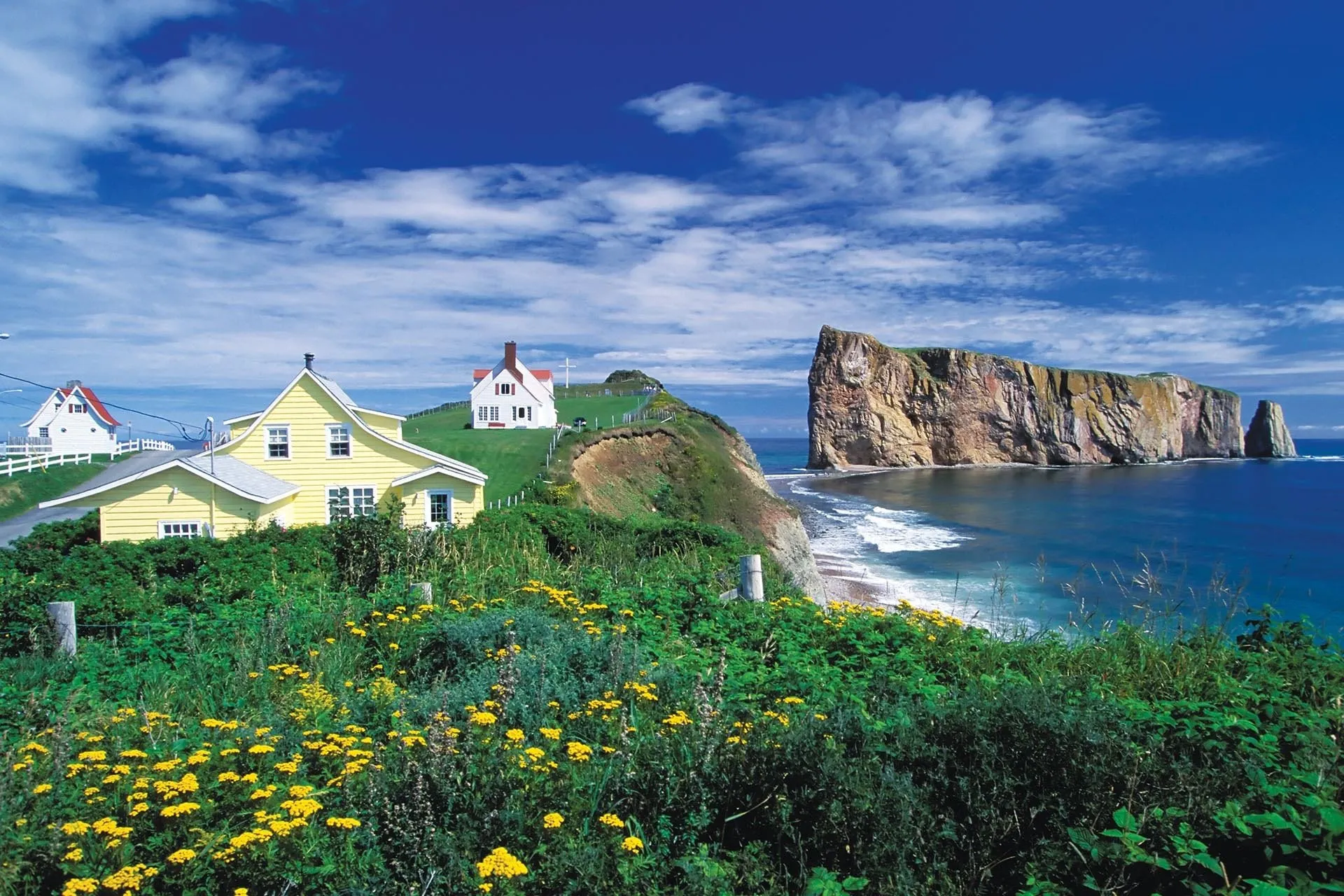
Percé Rock, or Rocher Percé in French, is a massive limestone sea stack pierced by a natural arch, standing at the tip of Quebec’s Gaspé Peninsula in the Gulf of Saint Lawrence. It is one of Canada’s most recognizable natural landmarks and the centerpiece of Parc national de l’Île-Bonaventure-et-du-Rocher-Percé, which also includes Bonaventure Island and its world-class northern gannet colony (verify park boundaries with Sépaq).
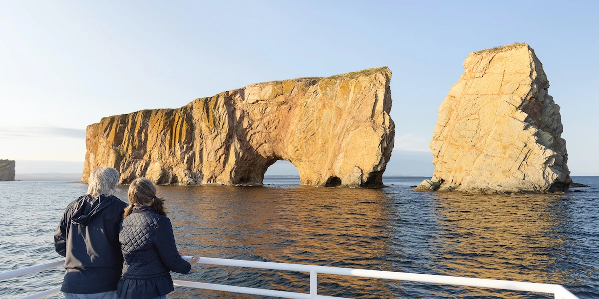
The rock gets its name from the 15- to 20-meter-high arch near its seaward end, through which a small boat can pass at high tide. At its highest point, the rock reaches almost 88 meters in height, with a length of 433 to 471 meters and a width of 90 meters, making it one of the largest natural arches in the world (confirm dimensions with the park authority).
Maya’s honest take: “The scale is hard to grasp from photos. Standing on the beach at low tide, you realize this isn’t just a rock with a hole; it’s a 400 million-year-old geological monument that happens to have one of the most photogenic windows on the planet.”
Quick facts at a glance
- Length: 433 to 471 meters (verify with park authority).
- Width: 90 meters at the broadest section (confirm with geological surveys).
- Height: 88 meters at highest point (check official park materials).
- Arch height: 15 to 20 meters, allowing small boat passage at high tide (verify with tour operators).
- Estimated weight: 5 million tonnes (confirm with geological sources).
- Age: approximately 400 million years old, Devonian period limestone (verify with Earth Magazine or geological surveys).
Location and access
- Located in Percé, Quebec, at the eastern tip of the Gaspé Peninsula (verify coordinates on the park website).
- Part of Parc national de l’Île-Bonaventure-et-du-Rocher-Percé, founded in 1985 (confirming the founding date with Sépaq).
- Accessible by car via Route 132, with parking and viewpoints in the village of Percé (check directions on Tourisme Gaspésie).
- Viewable from the beach at low tide and by boat tours year-round during park season (verify tour schedules with operators).
The geology behind Percé Rock’s pierced shape
Percé Rock is a sedimentary formation composed primarily of limestone, with veins of sandstone and siltstone running through its mass. It was formed during the Devonian period, over 400 million years ago, when this region was covered by a shallow tropical sea teeming with marine life (verify geological period with Earth Magazine).
The rock’s distinctive arch was carved by wave action and freeze-thaw cycles over millennia, exploiting natural weaknesses in the limestone layers. Today, the rock continues to erode at a rate of approximately 300 tonnes per year, losing about one tonne of material per day on average (confirm the erosion rate with Radio-Canada or Globe and Mail sources).
Paleontologists have identified over 150 fossil species within Percé Rock, including trilobites, brachiopods, and corals that lived in the ancient sea when these sediments were deposited (verify fossil count with geological surveys). The rock’s fossil record makes it a significant site for understanding Devonian marine ecosystems in eastern North America.
Maya’s honest take: “The erosion rate sounds abstract until you see the debris field at the base. Those 300 tonnes per year aren’t disappearing into thin air; they’re accumulating as talus slopes and beach rubble. It’s a reminder that this landscape is still actively being sculpted.”
Erosion timeline
- Current erosion rate: 300 tonnes per year, accelerating with climate change (verify with recent studies).
- Estimated time until arch collapse: 400 to 500 years, according to some geologists (confirm with Radio-Canada reporting).
- Estimated time until complete disappearance: 14,000 to 16,000 years at current rates (check with Globe and Mail or Earth Magazine).
- Historical context: the rock once had three arches, with the second-to-last collapsing on June 17, 1845 (verify date with Quebec Maritime sources).
Fossil highlights
- Over 150 identified fossil species from the Devonian period (verify count with geological surveys).
- Trilobites, brachiopods, and corals preserved in limestone layers (confirm species with park interpretive materials).
- Evidence of ancient tropical sea ecosystems that covered the region 400 million years ago (check with Earth Magazine).
- Fossil collecting is prohibited within the national park to protect the scientific resource (verify regulations with Sépaq).
A short history from Cartier to today
Percé Rock has been a landmark for Indigenous peoples, fishermen, and explorers for centuries, but its first recorded European sighting came in 1534 when Jacques Cartier sailed past during his first voyage to the Gulf of Saint Lawrence (verify Cartier sighting with historical sources). Cartier noted the rock in his journals, describing what was then a formation with three distinct arches.
Samuel de Champlain named the formation “Rocher Percé” in 1607 during his explorations of the Gulf, cementing the name that would stick for the next four centuries (confirm Champlain naming with historical records). The rock served as a navigation marker for fishermen and traders throughout the colonial period, its distinctive arch visible from miles away.
The most dramatic change in the rock’s appearance came on June 17, 1845, when the second-to-last arch collapsed, leaving only the single arch visible today (verify collapse date with the Quebec Maritime blog). This event marked the beginning of modern concern about the rock’s long-term survival and sparked the conservation efforts that eventually led to the creation of the national park in 1985 (confirm park founding date with Sépaq).
Maya’s honest take: “The 1845 collapse is a sobering reminder that these formations don’t last forever. What Cartier saw with three arches is already down to one, and that one has a geological expiration date. It makes every visit feel like witnessing a chapter in a very long, very slow story.”
Percé Rock through time: a mini timeline
- 400+ million years ago: Limestone sediments deposited in shallow tropical sea (verify with geological surveys).
- 1534: Jacques Cartier sights the rock with three arches during the first voyage (confirm with historical sources).
- 1607: Samuel de Champlain names the formation “Rocher Percé” (verify with historical records).
- June 17, 1845: The second-to-last arch collapses, leaving a single arch visible today (confirm date with Quebec Maritime).
- 1944: Surrealist poet André Breton visits Percé and writes “Arcanum 17” inspired by the rock (verify with literary sources).
- 1985: Parc national de l’Île-Bonaventure-et-du-Rocher-Percé founded to protect the rock and Bonaventure Island (confirm with Sépaq).
- 2026: Park open from May 31 to October 12, with restricted access to the rock base due to erosion (check current season dates on the official site).
Can you walk to Percé Rock? Tide Times explained
Yes, you can walk to Percé Rock at low tide when the sandbar is exposed, but only for about four hours at a time as the water recedes from a wide spit that allows the rock itself to be approached on foot (verify access rules with park authority). The tide schedule varies by roughly 50 minutes each day, so checking before setting out matters more than you might expect.
Important update: due to frequent rock falls, it is now forbidden to walk directly on Percé Rock itself in the Rocher Percé and Mont Joli sectors (confirm current restrictions with park authority). You can still walk out on the sandbar at low tide to get close to the base, but climbing on the rock is prohibited for safety and conservation reasons. Dogs and other pets are strictly prohibited in this area as well (verify pet restrictions with park rules).
The tide schedule is available at the park office, posted at the beach entrance, and online at marees.qc.ca for the Percé (Cap d’Espoir) area (check current tide charts before visiting). Low tide windows shift daily, so a morning low tide one day might be an afternoon low tide the next, requiring flexible planning if the walk is a priority.
Maya’s honest take: “I’ve seen visitors arrive at high tide, disappointed they can’t walk out, not realizing the window opens again in a few hours. Check the tide chart the night before, plan your day around it, and you’ll avoid the heartbreak of missing the walk entirely.”
Tide timing basics
- Low tide window: approximately four hours of exposed sandbar per cycle (verify duration with park materials).
- Daily shift: tide times move roughly 50 minutes later each day (check marees.qc.ca for exact times).
- Best planning: check the chart the night before and build your day around the low tide window (confirm tide source with Tourisme Percé).
- Safety note: do not attempt the walk if the tide is coming in, as you can be cut off from shore (verify safety warnings with park authority).
Current access rules
- Walking directly on Percé Rock is prohibited due to frequent rock falls (confirm with park authority).
- Sandbar walk to the base is allowed at low tide when exposed (verify current access with Sépaq).
- Dogs and pets are strictly prohibited in the Rocher Percé sector (check pet restrictions with park rules).
- Park access fee: $10.30 CAD for adults 18+, free for children 17 and under in 2026 (confirm the latest price directly with the operator).
What is the best time of day and season to visit Percé Rock?
The most magical time to see Percé Rock is at sunrise, when the first light colors the arch, or at dusk, as the sky ignites above Mont Sainte-Anne in the background (verify viewpoint directions with local tourism offices). Even under snow in winter, the rock presents a dramatic silhouette, though access is more limited outside the main park season.
The park is officially open from May 31 to October 12, 2026, with boat tours and full visitor services operating during this window (confirm season dates on the official site). The northern gannets on Bonaventure Island begin arriving in April but are not fully established until May to June, and they depart in October, making mid-June through September the peak season for combined rock and island visits (verify gannet season with birding sources).
Whale watching season in the Gulf of Saint Lawrence runs from May to December, with minkes, humpbacks, and fin whales occasionally spotted from boat tours around Percé Rock (confirm whale season with tour operators). If marine mammals are a priority, late summer and early fall offer the best odds, though sightings are never guaranteed.
Maya’s honest take: “Sunrise is the photographer’s golden hour here, but it also means fewer crowds on the beach. If you’re willing to wake up early, you’ll get the rock almost to yourself for an hour before the tour buses roll in.”
Best times by priority
- Photography: sunrise or dusk for dramatic light on the arch (verify sunrise times with local weather services).
- Gannet viewing: mid-June to September, when the colony is fully established (confirm gannet season with park authority).
- Whale watching: May to December, best odds late summer to early fall (check whale season with tour operators).
- Fewer crowds: early morning or late afternoon, especially weekdays outside July and August (verify peak times with Tourisme Gaspésie).
- Walking to the rock: plan around low tide windows, which shift 50 minutes daily (check marees.qc.ca for exact times).
Park operating hours 2026
- Season: May 31 to October 12, 2026 (confirm on official park website).
- May 31 to June 13 and September 20 to October 12: daily, 9 a.m. to 4 p.m. (verify hours with Sépaq).
- June 14 to September 19: daily, 9 a.m. to 5 p.m. (check current hours on official site).
- Boat departures: multiple daily departures from 9 a.m. to 3 p.m. depending on season (confirm schedule with tour operators).
Where are the best photo spots and viewpoints for Percé Rock?
The classic postcard view of Percé Rock is from the main beach in the village, looking east toward the arch with the Gulf of Saint Lawrence behind it. This is the view you see when driving into Percé along Route 132, and it’s particularly striking at sunset when the sky colors the water behind the rock (verify viewpoint location with local tourism offices).
For a different perspective, the hiking trails on Bonaventure Island offer elevated views looking back at Percé Rock from the north, with the arch framed against the open gulf (confirm trail access with park authority). The Des Colonies trail is recommended for families and offers a more direct route to viewpoints, while Les Mousses is longer but rewards with additional coastal scenery (verify trail difficulty with Sépaq).
Along Route 132 approaching Percé from the west, there are several pull-off points where you can capture the rock in the distance with foreground interest from the coastal road and fishing villages (check safe parking areas with local tourism offices). These wider landscape shots work well for establishing the rock’s setting within the Gaspé Peninsula.
Maya’s honest take: “Don’t just shoot from the main beach. The hike up on Bonaventure Island gives you a completely different angle, with the rock silhouetted against the horizon. It’s a 15- to 20-minute climb, but the payoff is a photo almost nobody else in your Instagram feed will have.”
Top viewpoints for photos
- Main beach in Percé village: classic frontal view of the arch (verify access with park authority).
- Bonaventure Island hiking trails: elevated views from the north (confirm trail access with Sépaq).
- Route 132 approach from the west: distant landscape shots with foreground interest (check safe pull-offs with Tourisme Gaspésie).
- Boat tour perspective: close-up shots of the arch and rock face (verify tour routes with operators).
- Sunrise from the eastern beach: golden light on the arch with fewer crowds (confirm sunrise direction with local weather services).
Photography tips
- Bring a telephoto lens to compress the arch against the background from distant viewpoints (verify lens recommendations with photography guides).
- Use a polarizing filter to reduce glare on the water and enhance sky contrast (check filter advice with camera retailers).
- Shoot in RAW format to maximize dynamic range recovery in post-processing (confirm editing workflow with photography resources).
- Arrive 30 minutes before sunrise or sunset for the best pre- and post-light (verify timing with local photographers).
- Respect park rules: do not climb on the rock or venture into restricted areas for photos (confirm restrictions with Sépaq).
How to get to Percé Rock: boat tours, parking, and walking distance
Percé is located at the eastern tip of the Gaspé Peninsula, accessible by car via Route 132, which circles the entire peninsula. From Quebec City, it’s approximately an 8- to 9-hour drive, while from Montréal the trip takes 10 to 11 hours, including ferry crossings (verify driving times with mapping services).
Once in Percé, parking is available in the village near the beach and park office, with the main viewpoints and sandbar walk accessible within a 5- to 10-minute walk from most parking areas (confirm parking locations with Tourisme Percé). Boat tour ticket offices are located on Rue du Quai in the harbor, with departures for Percé Rock and Bonaventure Island excursions running multiple times daily during the season (verify departure point with tour operators).
Boat tours are offered by Les Croisières Julien Cloutier and Les Bateliers de Percé, with prices around $45 CAD for adults, $25 for children 2 to 12, and free for children under 2 (confirm the latest price directly with the operator). These tours do not include the national park access fee, which must be purchased separately online or at the park office (check current fees on the official site).
Maya’s honest take: “Book your boat tickets in advance for July and August weekends, especially if you want to combine the rock tour with a landing on Bonaventure Island. The boats have limited capacity, and peak-season slots fill up fast.”
Boat tour options and pricing
- Les Croisières Julien Cloutier: $45 CAD adults, $25 children 3 to 12, free under 2 (confirm the latest price directly with the operator).
- Les Bateliers de Percé: similar pricing, with departures from 9 a.m. to 5 p.m. in peak season (check current schedule on official site).
- Tour duration: approximately 2 to 2.5 hours for rock circumnavigation, 4 to 6 hours including Bonaventure Island landing (verify duration with operators).
- Park access fee: $10.30 CAD for adults 18+, free for children 17 and under, not included in boat ticket (confirm the latest price directly with the operator).
Getting to Percé
- From Quebec City: approximately 8 to 9 hours via Route 132 around the Gaspé Peninsula (verify driving time with mapping services).
- From Montréal: approximately 10 to 11 hours, including ferry crossings (check current ferry schedules with Traverse Nord-Sud).
- Public transit: limited bus service via Orleans Express to Gaspé, then local connections to Percé (confirm schedules with bus operators).
- Nearest airport: Michel-Pouliot Gaspé Airport (YGP), with connections from Montréal and Quebec City (verify flight schedules with airlines).
Frequently asked questions
Can you walk to Percé Rock?
Yes, you can walk to Percé Rock at low tide when the sandbar is exposed for about four hours, but walking directly on the rock itself is now prohibited due to frequent rock falls (confirm current access rules with park authority). Check the tide schedule at marees.qc.ca or at the park office before visiting (verify tide source with Tourisme Percé).
How much does it cost to visit Percé Rock?
Viewing Percé Rock from the beach is free, and the sandbar walk at low tide has no additional charge (verify access fees with park authority). Boat tours to circle the rock cost $45 CAD for adults and $25 for children 2 to 12, and the national park access fee is $10.30 CAD for adults 18+, free for children 17 and under (confirm the latest price directly with the operator).
What is the best time of year to visit Percé Rock?
The park is open from May 31 to October 12, with the best combination of weather, wildlife, and services from mid-June to September (confirm season dates on the official site). Sunrise and dusk offer the best photo light, and the northern gannets on Bonaventure Island are fully established from May to June through October (verify gannet season with birding sources).
How long does the boat tour to Percé Rock take?
A basic rock circumnavigation tour takes approximately 2 to 2.5 hours, while combined tours that include a landing on Bonaventure Island take 4 to 6 hours total, including hiking time (verify duration with tour operators). Boat departures run multiple times daily from 9 a.m. to 5 p.m. during peak season (check the current schedule with operators).
Is Percé Rock the same as Percé Bay?
Percé Rock is the specific limestone sea stack with the natural arch, while Percé Bay refers to the broader body of water and coastal area surrounding the rock and village of Percé (verify geographic terms with tourism authorities). The rock is the centerpiece of the bay, but the bay encompasses a larger area, including Bonaventure Island and the harbor (check maps with Tourisme Gaspésie).
How old is Percé Rock, and when will it disappear?
Percé Rock is approximately 400 million years old, formed during the Devonian period from limestone sediments deposited in a shallow tropical sea (verify age with geological surveys). At the current erosion rate of 300 tonnes per year, geologists estimate the rock will disappear completely in 14,000 to 16,000 years, with the arch potentially collapsing in 400 to 500 years (confirm estimates with Radio-Canada or Globe and Mail sources).
Can you climb on Percé Rock?
No, climbing on Percé Rock is prohibited due to frequent rock falls and safety concerns (confirm current restrictions with park authority). You can walk to the base of the rock on the sandbar at low tide, but direct access to the rock face is restricted to protect both visitors and the geological formation (verify access rules with Sépaq).
Plan your trip: booking platforms we trust
I’ve tested these platforms across dozens of trips for reliability, customer support, and real inventory. They’re not all right for every situation, but each one solves a specific problem better than the alternatives.
Booking.com
Widest selection of hotels and B&Bs in Percé and the Gaspé Peninsula with free cancellation on most properties.
Expedia
Flight and car rental packages for reaching Quebec City or Montréal, then driving to the Gaspé Peninsula.
Kayak
Flight price comparison for routes to Michel-Pouliot Gaspé Airport (YGP) or regional Quebec airports.
TripAdvisor
Real traveler reviews for Percé restaurants, boat tour operators, and local attractions beyond the rock.
Hotels.com
Loyalty rewards program for repeat travelers booking Gaspésie accommodation across multiple trips.
Vrbo
Vacation rentals and cottages in Percé and surrounding Gaspé villages for families and longer stays.
More Quebec and Canada travel guides
If you’re planning a broader Quebec or Eastern Canada trip, these guides cover the next steps in your itinerary.
- Hotels in Quebec and Eastern Canada—budget to luxury accommodation guides with verified prices.
- Best things to do in Quebec—from Québec City’s Old Town to Gaspé Peninsula natural wonders.
- Travel planning guides—itinéraires, packing lists, and logistics for Canada road trips.
- Visa requirements for Canada—entry rules, eTA applications, and permitted stay lengths.
- How to find cheap flights to Canada—fare comparison strategies and booking timing tips.
WakaAbuja does its best to keep all information accurate at the time of publishing. Prices, policies, and availability change regularly. Always verify with official sources before you travel. We are not liable for errors caused by outdated information. Travel insurance is strongly recommended.