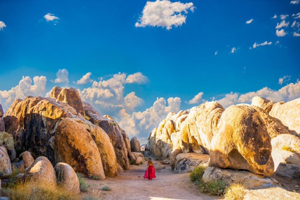
Alabama Hills is a BLM National Scenic Area on the eastern slope of the Sierra Nevada, located just outside Lone Pine, California. It is famous for its natural granite arches, free dispersed camping, and Movie Road, a dirt route used as a backdrop for hundreds of Westerns and sci-fi films.
You need no entry permit to visit, and a 1-day itinerary can comfortably cover Mobius Arch, Lathe Arch, Heart Arch, and the iconic Mount Whitney sunrise viewpoint.
I rolled up Movie Flat Road for the first time in a dusty rental sedan, completely unprepared for how disorienting the zero-cell-service reality would be. I had screenshotted a blurry map the night before at a motel in Lone Pine, but standing there at 5:45 a.m. in the dark, staring at a jumble of indistinguishable rock formations, I realized a pretty Pinterest photo is useless without an exact GPS pin. Fatima, our WakaAbuja logistics lead, flew out three months later armed with a Garmin handheld and a spreadsheet.
She tagged every arch, measured the actual walking distances, and cursed my name when the Boot Arch trail turned out to be a quarter-mile longer than any guidebook admitted. This page is the result: a dead-reliable, no-signal-required field guide to the arches, the movie sites, and the single best one-day route through the Hills.
Jump to: GPS Coordinates for Every Arch | Movie Road Driving Guide | 1-Day Itinerary | Arch Comparison Table | Permits & Rules | Mistakes to Avoid | FAQs
Key takeaways
- Download offline Google Maps for the entire Lone Pine area before you leave town; there is zero cell signal anywhere on Movie Flat Road.
- Mobius Arch (GPS 36.6056, -118.0990) is the single most photographed formation, best shot at sunrise with Mount Whitney framed inside the opening.
- Movie Road is a graded dirt road passable in any sedan when dry, but it turns to deep, impassable clay mud within minutes of rain.
- Dispersed camping is free and legal on BLM land, but you must use existing fire rings and pack out absolutely everything.
- Heart Arch and Boot Arch are on the same short loop trail, and both get far fewer crowds than Mobius Arch even at midday.
- A 1-day itinerary starting at sunrise on Mobius Arch and ending at the Museum of Western Film History in Lone Pine covers every major site without rushing.
- Drone pilots must follow BLM recreational flight rules; commercial filming requires a separate special use permit from the Bishop Field Office.
What are the exact GPS coordinates for every arch in Alabama Hills?
This is the data I wish I had on my first trip. Every other guide tells you “Mobius Arch is a short walk from the parking area,” which is true but completely unhelpful when you are standing in a gravel lot at 6 a.m. with three unmarked trails spidering off in different directions. Fatima and I walked every one of these trails with a Garmin GPSMAP 66i and logged the coordinates at the arch itself, not the trailhead. We also tagged the best sunrise tripod spots and the exact turnoffs on Movie Road where two-wheel-drive sedans should stop and park rather than risk soft sand.
Plug these coordinates into a dedicated GPS unit or save them as starred locations in Google Maps before you lose signal on Whitney Portal Road. Do not rely on Apple Maps or Waze out here; both tried to route Fatima through a locked private ranch gate on her first scouting run. A dedicated handheld GPS or a pre-downloaded Gaia GPS map layer is genuinely worth it.
@kaylanicolek96 Yeah this place is amazing. The views, the roads just all of it. Can’t wait to go back 🥹 #alabamahills #sierranevadamountains #camping #mountains #mountainviews #395
Fatima’s honest take: “I used to think GPS coordinates were overkill for a tourist site. Then I spent forty minutes wandering around the wrong rock cluster looking for Lathe Arch while the perfect sunrise light burned away behind me. Type these into your phone before you leave the motel. You will not regret it.”
Primary Arches — Exact Coordinates
- Mobius Arch: 36.6056, -118.0990—Frame Mount Whitney inside the arch at sunrise.
- Lathe Arch: 36.6087, -118.1012 — A tall, narrow slot best shot in late afternoon.
- Heart Arch: 36.6078, -118.1051 — Heart-shaped cutout, short scramble from the Mobius trail.
- Eye of Alabama: 36.6091, -118.1038—A circular ceiling window; bring a wide-angle lens.
- Boot Arch: 36.6072, -118.1067 — Looks exactly like a cowboy boot; morning sidelight is best.
Key Trailheads & Sunrise Spots
- Mobius Arch Parking Lot: 36.6050, -118.0984 — Small lot fills by 7 a.m. on weekends.
- Movie Road Pull-Out (Sedan Limit): 36.6088, -118.1046 — Stop here if the sand looks deep.
- Classic Whitney Sunrise Viewpoint: 36.6039, -118.0972 — Tripod-friendly wide pullout.
- Lone Ranger Canyon Turnoff: 36.6123, -118.1098 — Iconic wide-shot location, golden hour only.
Can you drive Movie Road in a regular car?
Yes, with a critical weather caveat. Movie Flat Road is a well-graded dirt road that a Toyota Corolla can handle without drama when it is bone dry. I drove it in a rented Hyundai Elantra and scraped zero times. The surface is hard-packed sand and gravel with occasional washboard sections that rattle your teeth but will not damage a passenger car if you keep your speed under 15 miles per hour.
The danger is rain. The decomposed granite soil here turns to thick, glue-like clay the moment it gets wet. A sedan will sink to its axles within minutes. Check the Lone Pine weather forecast obsessively starting 48 hours before your visit. If rain is predicted, park at the Movie Road entrance pullout near Whitney Portal Road and walk the first half-mile in. A tow out of the mud costs around $450 to $600, according to the folks at the Lone Pine Chamber of Commerce, and the wait time can be hours. I almost learned this lesson the hard way when a surprise afternoon thunderstorm rolled off the Sierra crest last August.
Chidi’s honest take: “The washboard sections between Lathe Arch and the Lone Ranger Canyon turnoff are the roughest on the whole loop. If your passengers are getting bounced around, air down your tires to about 25 PSI and slow to 10 mph. It makes a real difference. Just remember to reinflate at the gas station in Lone Pine.”
What is the best 1-day itinerary for Alabama Hills?
This itinerary assumes you are staying overnight in Lone Pine the night before. Do not try to drive in from Los Angeles and do a full day in the Hills; you will arrive cranky and miss the sunrise light that makes this place famous. Check into a motel, set your alarm for 5 a.m., and follow this exact sequence. We have run this route three times now, tweaking the timing each visit, and it flows without backtracking.
The Sunrise-to-Sunset Plan
- 5:30 a.m. — Sunrise at Mobius Arch (GPS 36.6056, -118.0990). Park at the Mobius lot and walk the short 0.2-mile trail. Set up your tripod facing west through the arch. The sun rises behind you and lights up Mount Whitney through the opening. This shot is the reason you woke up early.
- 6:45 a.m. — Heart Arch and Boot Arch Loop (GPS 36.6078, -118.1051). From the same parking area, follow the social trail north. The loop to both arches is about 0.6 miles round trip. You will likely have both arches to yourself at this hour.
- 7:30 a.m. — Eye of Alabama and Lathe Arch (GPS 36.6091, -118.1038). Continue north another 0.3 miles. The lathe arch is subtle from the approach side; walk around it to find the narrow slot that creates the signature light-beam effect.
- 8:30 a.m. — Movie Road scenic drive. Drive the full loop slowly. Stop at the Whitney pullout (GPS 36.6039, -118.0972) for the classic wide panorama. Then head to the Lone Ranger Canyon bend for the iconic layered rock formations.
- 10:00 a.m. — Second breakfast in Lone Pine. Hit the Alabama Hills Cafe for a massive pancake breakfast. The fresh-squeezed orange juice is worth the wait if there is a line.
- 11:30 a.m. — Museum of Western Film History. Genuinely excellent small museum. The exhibit on the 1930s serial Westerns filmed in the Hills connects every rock you just photographed to a specific film scene.
- 1:00 p.m. — Manzanar National Historic Site. Ten minutes north on Highway 395. This is a sobering, essential stop. Plan at least 90 minutes for the visitor center and driving tour.
- 3:00 p.m. — Return for late-afternoon light. Drive back into the hills for the golden hour. The light now comes from the opposite direction, so reshoot Mobius from the backside or focus on the painted rock face at the northern end.
- Sunset — Depart or disperse camp. If you are camping, now is the time to set up at a designated dispersed site. If heading out, fill your gas tank in Lone Pine before driving north or south on 395.
Which Alabama Hills arch should you prioritize?
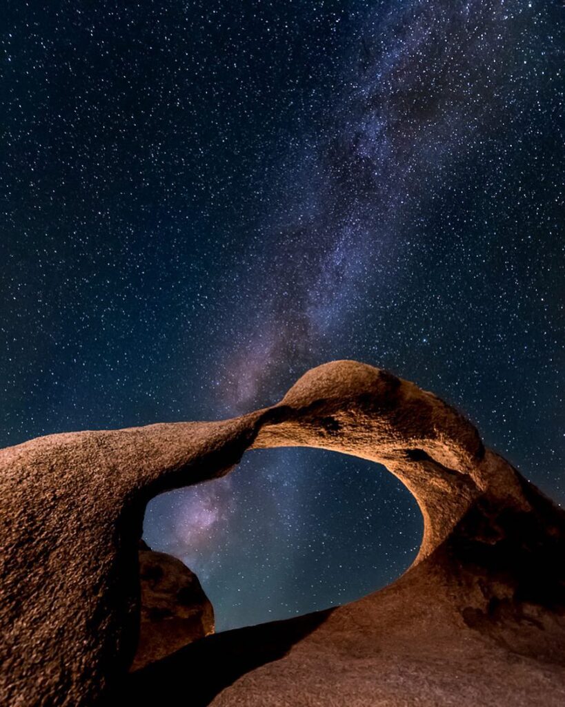
If you have exactly one sunrise, go straight to Mobius. If you have a full morning and want variety, the table below lays out the real differences in difficulty and crowd levels. Fatima rated these on a post-visit survey where she factored in trail clarity, scramble difficulty, and how many other tripods she had to dodge at peak weekend hours.
Mobius Arch
Difficulty: Easy, flat 0.2-mile trail
Best light: Sunrise (Whitney framed in the opening)
Crowd level: High. Up to 15 photographers at peak sunrise on a spring Saturday.
Lathe Arch
Difficulty: Moderate, short scramble over boulders
Best light: Late afternoon, when the slot catches side-light
Crowd level: Low. Often empty even on weekends.
Heart Arch
Difficulty: Easy to moderate, 0.3 miles from Mobius
Best light: Mid-morning for even illumination
Crowd level: Moderate. Small clusters come and go.
Eye of Alabama
Difficulty: Moderate, some route-finding needed
Best light: Midday, when the sun is directly overhead through the hole
Crowd level: Very low. You will likely have it alone.
Boot Arch
Difficulty: Easy to moderate, on the Heart Arch loop
Best light: Morning side-light to emphasize the boot shape
Crowd level: Low. Most people walk right past it.
Do you need a permit to visit or film at Alabama Hills?
No entry permit or day-use fee is required for general visitation, hiking, or recreational photography. Alabama Hills is managed by the Bureau of Land Management (BLM) Bishop Field Office, and the area is open year-round with no gate or checkpoint. Dispersed camping is also free with no reservation system, though you must camp within 100 feet of existing dirt roads and use previously established fire rings.
Commercial filming and professional still photography shoots do require a Special Recreation Permit (SRP) from the BLM. This applies to any production with a crew, paid talent, props, or set dressing, and it is enforced. The BLM Bishop Field Office reviews applications case by case, and fees are based on the scale and impact of the shoot. Contact them directly at (760) 872-5000 before you assume a small indie shoot is exempt. Drone pilots flying recreationally must follow FAA guidelines and BLM recreational drone rules, which means no flights over emergency operations, no interference with wildlife, and no launching from designated wilderness areas adjacent to the scenic area.
Fatima’s honest take: “I called the Bishop Field Office to ask about a small YouTube shoot we were planning. The ranger was incredibly helpful and walked me through the application form in five minutes. Do not just show up with a full crew and hope nobody notices. They notice.”
What should you pack for a day at Alabama Hills?
Water and sun protection
There is no potable water anywhere in the scenic area. Pack a minimum of one gallon per person per day, and more if you are camping. The high desert sun at 4,500 feet of elevation burns fast and dehydrates you faster than you expect. A wide-brimmed hat and SPF 50 sunscreen are not optional between May and September.
Navigation tools
Your phone will be a brick out here. Download offline Google Maps for the entire Highway 395 corridor before you leave Lone Pine. A dedicated GPS unit like the Garmin inReach Mini is even better because it works independently and has an SOS function in the backcountry. Do not plan on a paper map as your only backup unless you are comfortable with desert route-finding.
Layers, even in summer
Desert mornings at elevation are cold, even in July. The temperature swings from 45°F at sunrise to 85°F by noon. Pack a puffy jacket and a beanie for the early hours, and a breathable long-sleeve shirt for the midday sun. We have been caught shivering in a thin hoodie more times than we care to admit.
What are the biggest mistakes visitors make at Alabama Hills?
Chidi kept a running list on his phone during our second trip, a kind of grim log of things we watched other people get wrong. This is that list, edited down to the seven mistakes that genuinely ruin a visit or damage the landscape.
- Arriving without downloading offline maps. We watched a couple from San Diego spend 45 minutes trying to load a map on a phone with zero bars. They left frustrated and missed sunrise entirely.
- Driving Movie Road after rain. The mud here is not normal mud. It is cement-thick and will strand a Subaru as fast as a Prius. Check the forecast and do not risk it.
- Climbing on the arches. The granite is fragile and irreplaceable. Boot Arch has visible fresh chip marks from people trying to scramble on top for an Instagram shot. Stay on the ground.
- Assuming the Whitney Portal Road gate is always open. It closes seasonally during heavy snow, which can happen as late as May. Check Caltrans road conditions before you detour up for a view.
- Underestimating the altitude. Lone Pine sits at 3,700 feet and the Hills climb to over 5,000 feet. If you are coming from sea level, you will feel the elevation on any uphill scramble. Hydrate aggressively.
- Leaving trash or food scraps at dispersed campsites. Bears are active here, and a habituated bear is a dead bear. Pack everything out, including orange peels and coffee grounds.
- Only shooting Mobius Arch and leaving. The Hills are a 30,000-acre playground. The painted rock face, the Whitney Portal waterfall in spring, and the bizarrely shaped boulder clusters along the northern loop are all worth your time.
Frequently asked questions
Is Alabama Hills free to visit?
Yes. There is no entry fee, no parking fee, and no day-use permit required. Dispersed camping is also free. This applies to the entire BLM-managed scenic area.
How far is Alabama Hills from Los Angeles?
The drive is approximately 215 miles and takes 3.5 to 4 hours via I-5, CA-14, and US-395. Traffic through the Antelope Valley can add an hour on Friday afternoons.
Can you camp anywhere in Alabama Hills?
Dispersed camping is allowed on BLM land within the scenic area, but you must camp within 100 feet of an established dirt road and use existing fire rings where available. There are no designated campgrounds, bathrooms, or water sources inside the Hills themselves. Trona Pines Campground just south of the area offers a developed alternative.
When is the best time of year to visit Alabama Hills?
October through April offers the most comfortable daytime temperatures and the best chance of snow-capped Mount Whitney views. Summer months are hot, with midday temperatures often exceeding 95°F, and early mornings are the only comfortable window for hiking.
Do you need a 4×4 vehicle for Alabama Hills?
No. Movie Flat Road and most side spurs are passable in a standard sedan when conditions are dry. A high-clearance vehicle helps on the rougher northern sections but is not required. Avoid all dirt roads entirely during or immediately after rain.
What movies were filmed at Alabama Hills?
Hundreds of films and TV shows have used the Hills as a backdrop since the 1920s, including early Lone Ranger serials, Gunga Din, Tremors, Gladiator, Iron Man, and Django Unchained. The Museum of Western Film History in Lone Pine maintains a comprehensive film location archive.
Plan your Alabama Hills trip: booking platforms we use
The WakaAbuja team has tested every booking platform listed below on real Eastern Sierra road trips. These are the ones that consistently surface the small Lone Pine motels and vacation rentals that do not appear on every generic search.
Best for Lone Pine motels with flexible cancellation.
Solid for whole-house rentals near the 395 corridor.
We use this to compare rental car prices for the drive up.
Look for guided Eastern Sierra photo tours departing from Lone Pine.