advertisement
Bryce Canyon Hoodoos: The Complete Guide to Utah’s Most Iconic Rock Formations
Bryce Canyon hoodoos are tall, thin spires of rock formed by frost wedging and erosion over millions of years. The park contains the largest concentration of hoodoos on Earth, with some reaching up to 200 feet tall.
These unique formations are found only in a few places globally, but Bryce Canyon National Park in Utah offers the most accessible and dramatic display.
When Chidi from our Abuja team first saw Thor’s Hammer at sunrise, he nearly dropped his coffee. The spire glowed orange against a deep blue sky. That moment, he says, made him understand why travelers fly 7,000 miles to southern Utah.
We have visited Bryce Canyon three times as a team, and each trip reveals new details in these stone sentinels. This guide pulls together everything we learned, including the best viewpoints, trails, photography secrets, and practical logistics. No fluff, no generic praise. Just the facts and tips that actually help you plan a great visit.
Jump to: What are hoodoos? | How they form | Best named hoodoos | Best viewpoints | Best trails | Best time to visit | Photography tips | Practical info | Common mistakes | FAQ
Key takeaways
- Bryce Canyon has over 1,000 hoodoos, more than any other place on the planet.
- Frost wedging (freeze-thaw cycles) happens roughly 200 times per year at this elevation, making hoodoos grow and erode constantly.
- The best hoodoo viewing is at Sunrise Point and Sunset Point, both wheelchair accessible and less than 0.5 miles from parking.
- Navajo Loop and Queen’s Garden combined are the easiest way to walk among hoodoos. It is a 2.9 mile round trip with 550 feet of elevation change.
- Winter visits mean fewer crowds and snow-capped hoodoos, but some roads and trails close. Check the NPS website before you go.
- Thor’s Hammer is the most photographed hoodoo in the park. Arrive before 8 a.m. to avoid tripod traffic.
- You cannot climb or touch most hoodoos. The rock is fragile, and fines start at $325 for off-trail violations.
What Exactly Are Bryce Canyon Hoodoos?
A hoodoo is a tall, skinny rock spire that looks like a chimney or a standing human figure. Geologists call them “tent rocks” or “earth pyramids.” Unlike a regular pillar, hoodoos have a distinct cap rock on top that is harder than the material below.
That cap protects the softer rock underneath from eroding as quickly, creating the classic mushroom or totem pole shape.
Bryce Canyon hoodoos are made of limestone, dolomite, and siltstone. These sedimentary rocks were deposited in ancient lakes and rivers around 50 million years ago. The park’s elevation ranges from 6,600 to 9,100 feet, which means cold winters and intense summer thunderstorms. That combination drives the erosion process faster here than almost anywhere else on Earth.
Chidi’s honest take: “I have seen rock formations in Cappadocia and the Badlands of South Dakota. Nothing prepares you for the scale of Bryce’s hoodoos. They are not just tall. They are arranged in vast amphitheaters that stretch for miles. My first reaction was pure disbelief. The photos online do not capture the depth.”
Hoodoos are not the same as pinnacles or spires. A pinnacle is usually a single, uniform pillar. A hoodoo has that wider top and narrower base. The word “hoodoo” comes from the same root as “voodoo” and refers to the magical or eerie appearance of these formations.

Early European settlers and Native American tribes both recognized something otherworldly about them. The Paiute people who lived in the area believed hoodoos were ancient people turned to stone by a coyote spirit.
Best for
- First-time visitors: Start at Sunset Point for a panoramic view without hiking.
- Geology enthusiasts: Take the self-guided geology trail at Sunrise Point.
- Photographers: Sunrise Point faces east, perfect for morning light.
- Families: The Bristlecone Loop trail (1 mile paved) has great hoodoo views with no steep drops.
Worth considering
- Rainy day visits: Hoodoos look darker and more dramatic after rain, but trails become slippery clay.
- Full moon hikes: The park allows night hiking, but bring a headlamp and stay on marked trails.
- Stargazing: Bryce is a Dark Sky Park. Hoodoos under starlight are a surreal experience.
How Are Bryce Canyon Hoodoos Formed? Step by Step
@nationalparkdiaries How the Bryce Canyon Hoodoos Formed #brycecanyon #brycecanyonnationalpark #nationalpark #nationalparks #utah #geology
The process takes 50 million years and relies on a specific recipe: flat-lying sedimentary rocks, a high-elevation climate, and acidic rainwater. Step one: ancient lakes deposit layers of mud, silt, and calcium carbonate. These harden into the Claron Formation, which is the bedrock of Bryce Canyon.
Step two: tectonic forces uplift the Colorado Plateau starting about 20 million years ago. That lifting creates vertical cracks called joints in the rock.
Step three is the magic. Water seeps into those joints and freezes. At Bryce’s elevation, nighttime temperatures drop below freezing more than 200 days per year. When water freezes, it expands by 9%. That expansion acts like a tiny wedge, prying the rock apart.
Over thousands of cycles, the cracks widen into fins. Those fins erode further until some sections collapse, leaving standing spires with harder cap rock on top. Those are your hoodoos.
Fatima, our Lagos correspondent, asked park rangers about the rate of erosion. They told her that hoodoos lose about 0.5 inches of height per year on average. Some erode faster during wet years. At that rate, the tallest hoodoos (around 200 feet) will disappear in about 4,800 years. But new ones are always forming as the fins behind them continue to break down.
A 2019 study by the National Park Service measured freeze-thaw activity at Bryce. The data showed that south-facing hoodoos experience more cycles because daytime sun melts snow and ice, then night temperatures cause refreezing. North-facing hoodoos have less freeze-thaw but more wind erosion. This creates different shapes on opposite sides of the same amphitheater.
The Best Named Hoodoos in Bryce Canyon
The park has over 1,000 named hoodoos. Many were given fanciful names by early visitors and park employees. Some names stick because the shape actually resembles the thing. Others are pure imagination. Here are the ones worth finding.
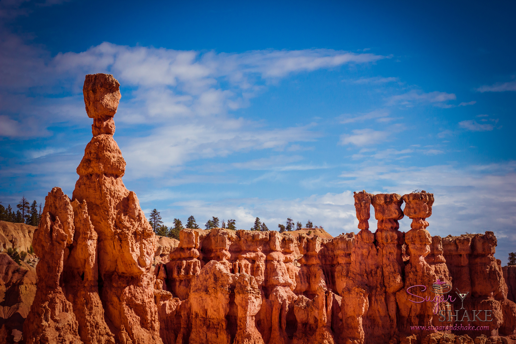
Thor’s Hammer
This is the superstar. A massive caprock balances on a narrow stalk. The shape looks like a hammer handle and head. You can see it from Sunset Point and from the Navajo Loop trail. The best angle is from the rim at sunset when the hammerhead catches the last light. Rangers say this hoodoo has about 1,000 years left before the cap rock falls.
Queen Victoria
Found along the Queen’s Garden Trail. This hoodoo resembles a woman’s profile wearing a crown. The trail was named after this formation. Early park literature from the 1920s called it “Queen Victoria” because the profile looked like the British monarch. The formation is best viewed from the switchbacks below Sunrise Point.
Wall Street
Not a single hoodoo but a narrow slot canyon lined with towering fins and spires. This section of the Navajo Loop trail drops into a deep cut where hoodoos rise on both sides. The effect is like walking through a canyon of skyscrapers. Wall Street is closed in winter due to icefall danger. Check the NPS alerts page before hiking.
Tower Bridge
A rare double arch hoodoo formation. Two spires with a rock bridge connecting them near the top. You need binoculars or a telephoto lens to see it clearly from the rim. The best viewing spot is Bryce Point, about 0.3 miles south of the main overlook.
The Three Wise Men
Three tall hoodoos standing in a row near Inspiration Point. They were named in the 1930s by a park concessionaire who thought the formation resembled the biblical Magi. Late afternoon light creates long shadows that make the grouping look like robed figures.
Best Viewpoints to See Bryce Canyon Hoodoos
Bryce Canyon has 10 named viewpoints along the 18-mile scenic drive. Four of them are essential for hoodoo viewing. The others offer similar views but require more driving for smaller rewards.
Sunrise Point: Faces east. Best for early morning when the sun hits the hoodoos directly. The elevation here is 8,000 feet. Arrive 30 minutes before official sunrise time. Parking fills by 7 a.m. from May through September. The Queen’s Garden trail starts here.
Sunset Point: Faces west. Despite the name, this is actually better for sunrise because the light illuminates Thor’s Hammer and the Silent City. The Sunset to Sunrise trail is a paved 0.5 mile walk connecting both points. Wheelchair accessible.
Bryce Point: The highest rim viewpoint at 8,300 feet. This gives a wide-angle view of the main amphitheater from the south. You can see the entire Navajo Loop trail system from above. The amphitheater depth is visible here more than any other point. Parking is limited to 40 spots, so arrive early.
Inspiration Point: Three levels of viewing decks. The upper deck has the best angle to see both the main amphitheater and the southern extension. Midday light works well here because the sun is behind you. Combine this with Bryce Point in one trip since they are only 1 mile apart.

Paria View and Yovimpa Point are farther down the scenic drive. Paria View looks west into the Paria River valley, with hoodoos scattered along the cliffs. Yovimpa is the southernmost point, elevation 9,100 feet. The hoodoos here are older and more eroded, looking like rounded stumps instead of spires. Worth the drive if you have an extra hour.
Best Trails to Walk Among the Hoodoos
Viewing from the rim is impressive. Walking among the hoodoos is unforgettable. The park has eight main trails that descend into the amphitheaters. These three give the best hoodoo experience for different fitness levels.
@everywherewithclaire Best Hikes In Bryce Canyon (Easy to Hard) 🥾 1. Bryce Point Trail Miles: 0.2 Rating: Easy Notes: Great for sunrise 2. Mossy Cave Trail Miles: 1 Rating: Easy Notes: Trailhead actually located outside main gate 3. Navajo Loop and Queens Garden Trail ✨my favorite✨ Miles: 3 Rating: Moderate Notes: Go counterclockwise for an easier ascent 4. Fairyland Loop Trail Miles: 8 Rating: Hard Notes: Trailhead access is closed to vehicles in winter You can find a map and full trail details on my blog! #brycecanyonnationalpark #brycecanyon #utah #utahhiking #exploreutah
Fatima’s honest take: “The Navajo Loop is not a casual stroll. The switchbacks are steep, and the altitude makes every step harder. I live at sea level in Lagos. The 8,000 foot elevation hit me hard. Take water, go slow, and do not feel bad about turning back early. The rim views are still world-class.”
Navajo Loop (1.3 miles round trip): Starts at Sunset Point. Drops 550 feet into the amphitheater. The trail passes through Wall Street, a narrow slot between hoodoos. Then it climbs out via the Two Bridges section. This is the most popular trail, so expect crowds between 10 a.m. and 2 p.m. The trail is well maintained but has steep drop-offs with no railings. Not recommended for anyone with severe vertigo.
Queen’s Garden (1.8 miles round trip): Starts at Sunrise Point. This is the easiest trail into the hoodoos, with a gradual descent of 320 feet. The trail winds past Queen Victoria hoodoo and through a forest of smaller spires. Combine with Navajo Loop for a 2.9 mile figure-eight route. That combination is the best way to see the greatest number of hoodoos in a single hike.
Fairyland Loop (8 miles): A full-day hike starting at Fairyland Point (north of Sunrise Point). This trail goes deeper into the backcountry, passing hoodoos that most visitors never see. Tower Bridge is along this route. The trail has 1,500 feet of elevation change and takes 4 to 5 hours. Carry at least two liters of water. No water sources on the trail.
Peekaboo Loop (5.5 miles) connects to the Navajo and Queen’s Garden trails. It is a challenging loop with steep climbs and exposed sections. Mountain bikers are allowed only on the paved section near the rim, not on Peekaboo. Check with the visitor center for current trail conditions before attempting Peekaboo.
Best Time of Day and Season for Hoodoo Viewing
Timing changes everything at Bryce Canyon. The angle of light transforms hoodoos from flat gray to glowing orange to deep purple. Here is what each season and time of day offers.
@chasingnpus Bryce Canyon is one of those parks where timing changes everything. A lot of people stop there: • in the middle of the day • on the way to or from another park • and treat it like a fast scenic stop But that usually means they miss what makes Bryce feel so special. Why timing matters so much at Bryce: • the amphitheater often looks best in early light • cooler temps make trails more enjoyable • popular viewpoints feel calmer earlier • and the hoodoos look more dramatic when the light is softer If you want Bryce to feel better: ✔️ aim for sunrise / early morning when possible ✔️ do at least one below-the-rim trail if conditions allow ✔️ don’t treat it like a random stop between bigger parks ✔️ give it enough time to actually feel it Bryce is not just pretty. It’s one of the most unique parks in Utah, if you hit it at the right time. 👉 Save this before your trip #BryceCanyonNationalPark #UtahTravel #NationalParkTips #HikingUtah #USARoadTrip
Sunrise (May to September): The golden hour lasts about 45 minutes. Hoodoos facing east, including most of the main amphitheater, turn bright orange. The temperature at sunrise is often 40 to 50 degrees Fahrenheit, even in summer. Bring a jacket. The park opens at 6 a.m. during peak season. Enter before 7 a.m. to avoid the two-hour wait at the entrance gate.
Late afternoon (3 p.m. to 5 p.m.): Shadows stretch long across the amphitheater floor. This is the best time for photography because the contrast between lit hoodoos and dark shadows creates depth. Bryce Point and Inspiration Point face south and west, so they catch the best late light.
Winter (December to February): Snow accumulates on hoodoo caps, creating a striking white and red contrast. Crowds drop by 80% compared to summer. The scenic drive is plowed, but some trails close due to ice. The Navajo Loop is often closed. The Bristlecone Loop and rim trails remain open. Temperatures average 20 to 35 degrees Fahrenheit. Pack microspikes for your boots.
Spring (March to April) and Fall (September to October): Ideal weather, with daytime highs from 50 to 70 degrees. Wildflowers appear in late May. Fall colors are minimal because the park is mostly coniferous trees, but the lower elevations have some aspen groves that turn yellow in October. These shoulder seasons have moderate crowds. Lodging prices drop by 30% compared to summer.
Avoid July and August afternoons: Afternoon thunderstorms are common. Lightning strikes on the rim are a real danger. Rangers close trails when lightning is within 10 miles. Also, the summer sun at 8,000 feet is intense. Sunburn happens in 20 minutes without protection.
How to Photograph Bryce Canyon Hoodoos Like a Pro

After five trips with different camera gear, we have a clear set of rules for hoodoo photography. These tips work with phones or professional cameras.
Best camera settings
Shoot in RAW format if your camera allows it. Hoodoos have a wide dynamic range, meaning bright highlights and deep shadows. RAW captures detail in both. Set your white balance to “cloudy” even on clear days. That adds warmth to the rock colors. Aperture priority mode at f/8 to f/11 keeps the entire scene sharp from foreground hoodoos to distant cliffs.
The polarizer trick
A circular polarizing filter removes atmospheric haze and makes the red rock pop. Turn the filter until the sky darkens slightly. Do not overdo it. You still want natural-looking colors. This filter also cuts reflections on wet rocks after rain.
Phone photography tips
Tap the screen to set focus on a voodoo in the midground. Then swipe down to lower exposure by about 0.7 stops. The automatic exposure often blows out the sky. Use the 2x or 3x zoom lens if your phone has one. Digital zoom beyond that loses detail. For night shots, place your phone on a small tripod and use the 3- or 10 second timer to avoid shake.
Where to set up
For sunrise, position yourself at Sunrise Point or the north end of Sunset Point. For sunset, Inspiration Point’s upper deck. For star trails over hoodoos, hike 0.5 miles down the Queen’s Garden trail to get foreground hoodoos with the night sky behind them. Check the moon phase before a night shoot. A full moon washes out stars but lights up the hoodoos beautifully.
The National Park Service has a detailed photography guide available at the visitor center. Ask for the “Hoodoo Lighting Conditions” handout. It lists the best times for each viewpoint by month. The official NPS site also has a photography resources page with example settings.
How to Plan Your Trip to See Bryce Canyon Hoodoos

Practical details separate a smooth trip from a frustrating one. We learned these lessons the hard way so you do not have to.
Entry fees and passes
As of this year, entry is $35 per private vehicle for seven days. Motorcycles cost $30. Individuals on foot or bicycle pay $20. The America the Beautiful annual pass ($80) covers Bryce Canyon along with all other national parks.
You can buy passes at the entrance station or online through the USGS store. The park accepts credit cards but not all mobile payment systems. Bring a physical card.
Parking and shuttle
The main parking lots at Sunrise, Sunset, Bryce, and Inspiration Points fill by 9 a.m. from April through October. A free shuttle runs from the Visitor Center to these viewpoints every 15 minutes from 8 a.m. to 6 p.m. The shuttle does not go to Paria View or Yovimpa Point.
In summer, arriving after 10 a.m. means parking at the shuttle lot near the entrance and riding in. Do not leave valuables visible in your car. Thefts from vehicles occur at the main lots about 10 to 15 times per season, according to park rangers.
Getting there
The nearest major airport is Las Vegas McCarran (LAS), 265 miles away. That drive takes 4.5 hours. Salt Lake City International (SLC) is 270 miles, or 4.5 hours. St. George Regional Airport (SGU) is 145 miles and 2.5 hours, but flights are limited.
From Las Vegas, take Interstate 15 north to exit 95 (Utah 20). Then follow Highway 89 to Highway 12. From Salt Lake City, take Interstate 15 south to exit 95. The park entrance is on Highway 63, three miles south of the town of Bryce Canyon City.
Where to stay
The Bryce Canyon Lodge inside the park is the only in-park accommodation. It books solid 6 to 8 months in advance. Cancellations happen, so check the Booking.com listing for last-minute openings. The towns of Tropic (7 miles east) and Bryce Canyon City (1 mile north) have motels, cabins, and RV parks. For vacation rentals with full kitchens, Vrbo has several properties in Tropic near the park entrance.
Camping is available inside the park at North Campground and Sunset Campground. Reservations are required for Sunset and can be made through Recreation.gov. North is first-come, first-served.
What Should You Avoid When Visiting Bryce Canyon Hoodoos?
Mistakes can ruin a trip or get you fined. Here are the most common ones we have seen or made ourselves.
- Walking off trail: The crust on hoodoo soil is a living biological soil crust. It takes 50 years to recover from a single footprint. Rangers issue citations with fines starting at $325. Stay on paved paths and designated trails at all times.
- Underestimating altitude: Bryce’s rim sits at 8,000 feet. Visitors from sea level often feel short of breath and have headaches and nausea. Drink three liters of water per day minimum. Avoid alcohol for the first 24 hours. If you feel dizzy or confused, descend to a lower elevation immediately. The town of Tropic is at 6,200 feet.
- Forgetting sun protection: The UV index at this altitude is 40% higher than at sea level. Sunscreen, a wide-brimmed hat, and sunglasses are not optional. We saw a tourist with second-degree burns on his neck in June because he thought a light jacket was enough.
- Ignoring weather warnings: Summer thunderstorms produce lightning that kills or injures about one person per decade in the park. Do not be that statistic. If you hear thunder, leave the rim and get inside a vehicle or building. Wait 30 minutes after the last thunderclap before going back out.
- Arriving without water: There is no drinking water on trails except at the visitor center and lodge. Carry at least one liter for short hikes and two liters for anything over 3 miles. Dehydration symptoms appear faster at high elevation.
- Visiting only the main viewpoints: The scenic drive extends 18 miles south to Yovimpa Point. Most tourists stop at Sunrise and Sunset Points, then leave. You will find smaller crowds and equally impressive hoodoo views at Natural Bridge, Farview Point, and Ponderosa Canyon. Drive the full length.
- Forgetting to check trail closures: The NPS website updates trail status daily. Wall Street on the Navajo Loop closes in winter due to ice. The Fairyland Loop sometimes closes for raptor nesting from March through July. Check before you drive to the trailhead.
The official NPS current conditions page has real-time updates on trail and road closures. Bookmark it on your phone before you travel.
Frequently asked questions
How tall are the hoodoos in Bryce Canyon?
The tallest hoodoos reach about 200 feet, roughly the height of a 15 story building. Most hoodoos in the main amphitheater are between 80 and 120 feet tall. The height varies because of different erosion rates. South-facing hoodoos tend to be shorter because they experience more freeze-thaw cycles than north-facing ones.
What is the most famous hoodoo in Bryce Canyon?
Thor’s Hammer is the most photographed and recognized hoodoo in the park. It sits near Sunset Point and features a massive cap rock balanced on a narrow stalk. The formation appears on most Bryce Canyon promotional materials, including the park brochure and the Utah state travel guide. Rangers estimate the cap rock weighs over 200 tons.
Can you walk among the hoodoos?
Yes, the park has several trails that descend into the amphitheater, allowing you to walk right next to hoodoos. The Navajo Loop and Queen’s Garden trails are the most accessible. You cannot touch or climb on hoodoos. The rock is fragile, and touching accelerates erosion. Stay on the trail to protect the formations and avoid fines.
When is the best time to see hoodoos in Bryce Canyon?
The best times are sunrise and late afternoon in spring (May) and fall (September). The light angles create dramatic shadows that highlight the hoodoo shapes. Summer midday sun makes the colors look flat and washed out. Winter offers snow-capped hoodoos and no crowds, but some trails close. Check the park’s sunrise/sunset table before you go.
Are hoodoos found anywhere else?
Yes, but Bryce Canyon has the largest concentration. Other locations include Goblin Valley State Park in Utah (smaller, shorter hoodoos called goblins), Cappadocia in Turkey (hoodoos carved into fairy chimneys), and the Alberta Badlands in Canada (hoodoos made of sandstone). None of these places match Bryce’s density or accessibility.
How long does it take to see the main hoodoo viewpoints?
You can see the four main viewpoints (Sunrise, Sunset, Bryce, Inspiration) in 2 to 3 hours without hiking. Add another 2 hours for the Navajo Loop trail. To see the full scenic drive and do one moderate hike, plan for a full day from 8 a.m. to 5 p.m. Many visitors spend two days: one for the rim viewpoints and one for hiking among the hoodoos.
Is Bryce Canyon actually a canyon?
No. Despite the name, Bryce Canyon is not a true canyon. A canyon is carved by a river or stream. Bryce’s amphitheaters were formed by freeze-thaw erosion on the edge of the Paunsaugunt Plateau. The park kept the name because early settlers called it a canyon and the name stuck. The correct geologic term is an “amphitheater” or “alcove.”
Do I need a 4×4 vehicle to visit Bryce Canyon?
No. All main viewpoints and trailheads are accessible by regular passenger vehicles on paved roads. The 18 mile scenic drive is fully paved. During winter, the park plows the main road but may require chains after heavy snow. Rental cars with all-season tires are fine for 95% of conditions. Check the weather forecast before driving in December through February.
Plan your trip: booking platforms we trust
The WakaAbuja team has tested these platforms for hotel, flight, and activity bookings across dozens of national park trips. Each one offers specific advantages for Bryce Canyon travel. We list them so you can compare prices and policies before booking. Always read the cancellation terms carefully.