Mendenhall Glacier: Complete Visitor Guide & Glacier Facts
Fact-Checked By Maya Whitfield, Senior Travel Editor at WakaAbuja
Mendenhall Glacier is a 13-mile-long river of ice flowing from the Juneau Icefield into Mendenhall Lake, about 12 miles from downtown Juneau, Alaska. In November 2025, the glacier’s face pulled back from the lake for the first time in modern history, changing what visitors see from the main viewing areas. You can still visit the glacier year-round, but the classic “glacier meets water” view now requires a different trail or a tour boat.
I have stood on the shore of Mendenhall Lake in June, watching icebergs drift past while Nugget Falls roared in the background. The glacier has changed dramatically since my first visit, and the 2025 lake separation is not a small update. It rewrites how you should plan your day. This guide gives you the science and history you would get from an encyclopedia, plus the hours, costs, trail times, and safety warnings that actually get you to the right viewpoint.
Jump to: What Is Mendenhall Glacier | What’s New in 2025–2026 | How to Visit | Trail-by-Trail Guide | FAQ | Before You Go
Key takeaways
- The glacier’s face separated from Mendenhall Lake in November 2025, a first in modern recorded history.
- The main Visitor Center and Photo Point Trail still offer a clear view of the glacier, just not the classic water-meets-ice scene.
- Parking costs $5 for a day pass, but the lot fills early in summer. The shuttle from downtown Juneau is the most reliable option.
- Nugget Falls is a 2-mile round-trip flat walk and remains the best easy waterfall-plus-glacier view.
- The West Glacier Trail ice caves are dangerous. Do not enter them without a guided tour and proper gear.
- Suicide Basin floods can close trails and the campground with very little warning. Check the USFS alert page before you drive out.
- Summer salmon runs at Steep Creek bring black bears. Carry bear spray and keep a safe distance.
What is Mendenhall Glacier?
Mendenhall Glacier is a 13-mile-long outlet glacier that drains the Juneau Icefield, one of the largest icefields in North America. It flows into Mendenhall Lake, a glacial lake that only formed as the ice retreated over the last century. The glacier sits within the Tongass National Forest, managed by the U.S. Forest Service.
The Tlingit people originally called the glacier Sitaantaago, meaning “Glacier Behind the Town,” and Aak’wtaaksit, referring to the Auk Tlingit clan. The Mendenhall name came in 1891 from Thomas Corwin Mendenhall, a scientist who served on the U.S. Coast and Geodetic Survey. The lake, the glacier, and the surrounding valley all carry his name today.
Since the 1700s, the glacier has retreated about 2.5 miles. Since 1929, the retreat has been measured at roughly 1.75 miles. Those numbers matter because they explain why the visitor experience keeps changing. The viewpoint that once showed ice calving directly into the lake now shows a growing gap between water and ice.
The glacier is changing fast: what’s new in 2025–2026
If you read only one section before your trip, make it this one. The Mendenhall Glacier you see today is not the one in most older travel photos.
The November 2025 separation from Mendenhall Lake, explained
In November 2025, the glacier’s terminus pulled back far enough that it no longer touched Mendenhall Lake. This was the first time in modern recorded history that the ice face and the lake were fully separated. The event was reported by local outlet KTOO and confirmed by U.S. Forest Service staff. The practical result for visitors is that the iconic “glacier calves into the lake” scene from the main Photo Point Trail is gone, at least for now.
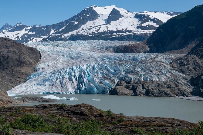
You can still see the glacier clearly from the Visitor Center area. It looks like a white and blue ice wall sitting behind a strip of newly exposed rock and sediment. But if you want the classic glacier-meets-water view, you now need to hike further up the West Glacier Trail or take a tour boat onto the lake and look toward the face from a different angle.
Suicide Basin floods: what visitors should know

Suicide Basin is a side basin of the glacier that fills with meltwater and periodically drains suddenly into Mendenhall Lake. This is called a glacial outburst flood. In 2023, a major flood destroyed two buildings along the lake and forced evacuations. Smaller flood events have happened since. The Forest Service monitors the basin and posts alerts when water levels rise. Check the official Tongass National Forest Mendenhall page before you hike near the lake shore or camp in the area.
I was in Juneau during a moderate flood warning in 2024. The lake rose visibly in a few hours, and rangers closed the Steep Creek boardwalk. The warning system works, but only if you pay attention to it.
How to visit Mendenhall Glacier
The Mendenhall Glacier Visitor Center is at 6000 Glacier Spur Road, about 12 miles from downtown Juneau. The drive takes 20 to 25 minutes without traffic. If you are arriving by cruise ship, a shuttle or tour bus is the easiest option because the parking lot fills early.
Getting there from downtown Juneau
You have three realistic options. First, drive yourself and pay the daily parking fee. Second, take a shuttle from the cruise ship docks or downtown. Several companies run shuttles every 30 minutes in summer, and round-trip fares are usually between $30 and $45 per person. Third, book a guided tour that includes transport and narration. Tour prices vary widely, so check the official site or your cruise line before you commit.
Hours, parking, and admission costs
The Visitor Center is generally open from 8:00 a.m. to 7:30 p.m. in summer, with shorter hours in fall and winter. The trails and viewing areas are open year-round, but the building itself may close on federal holidays. Parking costs $5 for a day pass, and the fee is paid at a kiosk in the lot. The America the Beautiful federal lands pass covers the parking fee.
Cost breakdown at a glance
Parking: $5 per vehicle, or covered by federal lands pass
Visitor Center entry: Free, though a small donation is suggested
Shuttle from downtown: $30–$45 round trip, seasonal
Guided tour with transport: $75–$150 depending on operator and season
West Glacier Trail guided ice cave tour: $200–$400, includes gear and glacier access
Prices change, so verify with the official USFS page or your tour operator before you book.
Best time of day and season to go
Early morning, right when the Visitor Center opens, gives you the best light and the fewest people. By 10:00 a.m. in July, the main Photo Point Trail is shoulder to shoulder. Late evening is also good for photographers, especially in June when the sun stays up past 10:00 p.m. For the best glacier views, go in May or June when the lake still has icebergs and the surrounding peaks hold snow. Fall offers quieter trails and golden light, but the glacier face may be more obscured by clouds.
If you need to compare flight options into Juneau, I use Kayak to check prices from Seattle or Anchorage first. Juneau is a hub for Alaska Airlines, but prices swing wildly in summer.
Trail-by-trail guide: which Mendenhall trail is right for you?
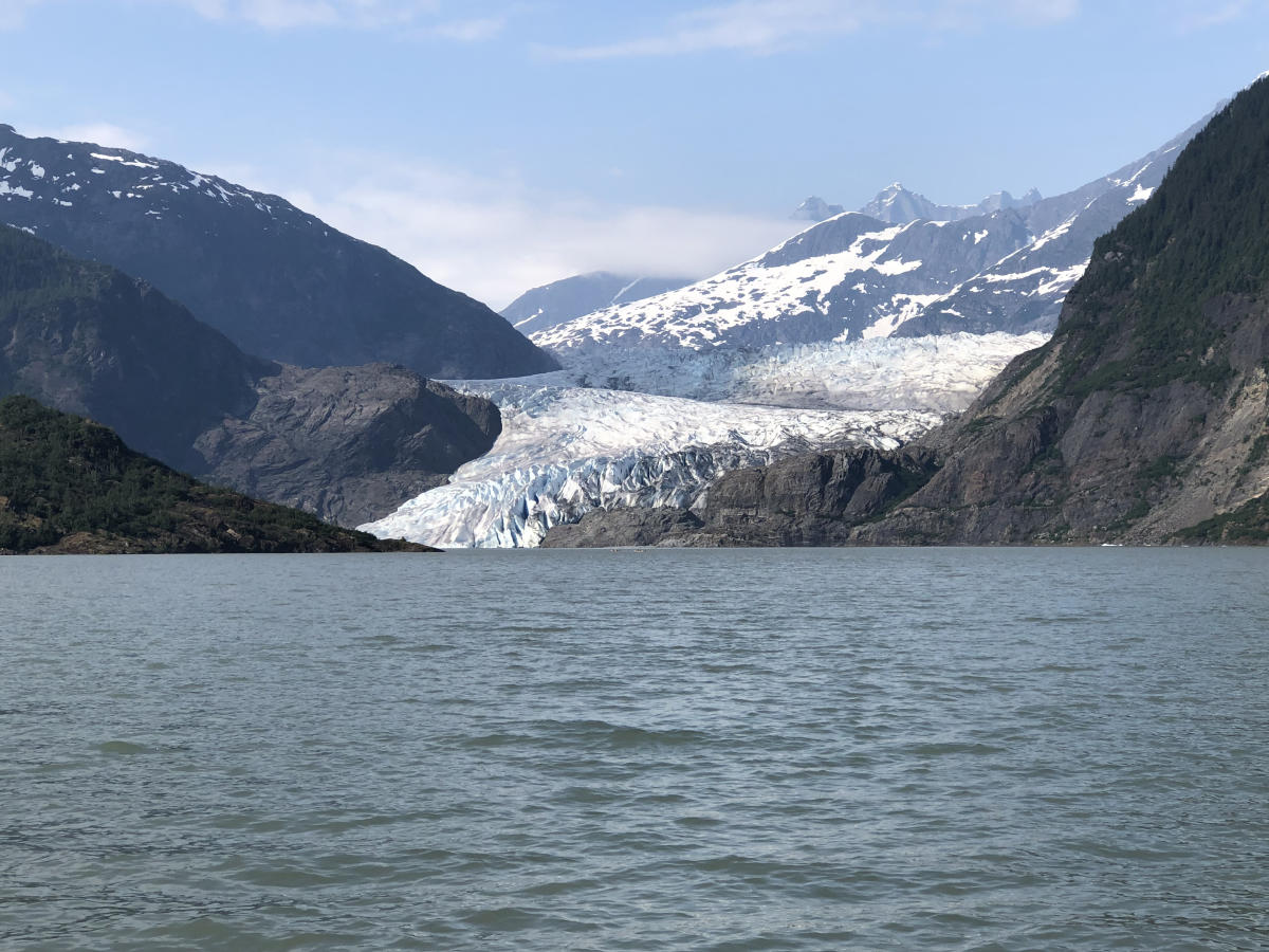
All trails start from the Visitor Center area unless noted. The distances below are round trip. I have hiked every one of these, most recently in late spring this year, and the condition notes reflect current trail reports.
Nugget Falls Trail
Distance: 2.0 miles out and back. Difficulty: Easy. Estimated time: 45 minutes to 1 hour.
This is the one I recommend for families and anyone short on time. The trail is wide, flat, and gravel-surfaced. It leads to the beach at the base of Nugget Falls, a 377-foot waterfall pouring directly into Mendenhall Lake. From the beach, you get a clear view of the glacier face across the lake. The waterfall is the star, but the glacier in the background makes it one of the best easy walks in Alaska.
Skip if you want solitude. This is the most popular trail in the area.
Photo Point Trail
Distance: 0.4 miles out and back. Difficulty: Easy. Estimated time: 15 minutes.
This short paved path runs from the Visitor Center to a raised overlook with a straight-on view of the glacier. It is wheelchair accessible and has interpretive signs. Before the 2025 separation, this was the classic glacier-meets-lake photo spot. Now the view is of the ice wall behind a strip of bare rock. Still worth doing, but do not expect the old postcard image.
Skip if you are doing Nugget Falls anyway. The Falls trail gives you the same glacier view from a better angle.
Steep Creek Trail
Distance: 0.25-mile loop. Difficulty: Easy. Estimated time: 20 minutes.
This boardwalk loop runs along Steep Creek, a salmon spawning stream. In July and August, the creek is thick with sockeye and coho salmon. Black bears come here to fish, and the Forest Service often closes the boardwalk when bears are active. Check the posted signs at the trailhead. I have seen a sow with two cubs on this trail from the boardwalk, which is exactly the right distance.
Skip if you are visiting in winter. The salmon are gone, and the creek is quiet.
East Glacier Loop Trail
Distance: 3.5-mile loop. Difficulty: Moderate. Estimated time: 2 to 3 hours.
This trail climbs through forest and offers occasional views of the glacier through gaps in the trees. It is less crowded than Nugget Falls but also less scenic overall. The trail can be muddy after rain, and there are some rocky sections. I like this one for a longer walk when the main trails are packed.
Skip if you want the best glacier view for your effort. Nugget Falls or the West Glacier Trail are better choices.
Trail of Time
Distance: 1.0 mile loop. Difficulty: Easy to moderate. Estimated time: 40 minutes.
This is the most underrated trail at Mendenhall. Markers along the path show where the glacier’s edge stood at different points in the last century. You can literally walk through the glacier’s retreat history. It is a short loop with some elevation gain, and it pairs well with Photo Point. I bring every first-time visitor here because it makes the retreat numbers real.
Skip if you only care about the waterfall. This is more educational than scenic.
West Glacier Trail
Distance: 4.0 miles round trip to the main overlook, longer to the ice caves. Difficulty: Strenuous. Estimated time: 4 to 6 hours.
This is the serious hike. The West Glacier Trail climbs steeply from the west side of the lake, gaining about 1,200 feet before reaching overlooks that look directly onto the glacier. The trailhead is separate from the Visitor Center, off Montana Creek Road. The path is rocky, root-covered, and often wet. You need real hiking shoes and layers. The payoff is the closest non-guided view of the ice you can get without a boat or a helicopter.
Skip if you are not prepared for a full day or have any mobility concerns.
Ice caves on the West Glacier Trail: safety warning
The ice caves near the glacier’s edge are real, and they are also deadly. The caves form as meltwater carves through the ice, and they can collapse without warning. Several people have been injured or killed entering ice caves in Alaska. Do not enter an ice cave unless you are with a licensed guide who has current glacier safety training. Guided tours provide helmets, crampons, and route assessment. The glacier is moving, the ice is not stable, and the risk is not worth the Instagram photo.
What you’ll see: wildlife, Nugget Falls, and the lake
Mendenhall is not just a glacier. The lake, the waterfall, and the wildlife make it a full ecosystem. Nugget Falls is the most obvious non-glacier feature, and it is worth seeing even if the glacier were not there. The waterfall drops 377 feet in two clear tiers and crashes into the lake. In late summer, the volume drops, but the sight is still impressive.
Black bears are common near Steep Creek and the lake shore from July through September. The Forest Service closes trails when bear activity is high. Porcupines, mountain goats, and bald eagles are also regulars. I have watched an eagle harass a sea gull over a salmon carcass at the Steep Creek boardwalk. The wildlife viewing here is as good as any national park in the Lower 48.
Mendenhall Lake itself is a young feature. It formed as the glacier retreated, and the lake is still expanding. Icebergs calve into the lake in spring and early summer, then drift toward the shore. The ancient tree stumps exposed by the retreating ice, some dated between 1,200 and 2,350 years old, are visible in places along the shore. They are a quiet reminder that this valley was forest before the ice advanced.
The science behind the retreat
The Mendenhall Glacier has been retreating for over 250 years, since the end of the Little Ice Age. The retreat rate has accelerated in recent decades. University of Alaska researchers and U.S. Forest Service scientists attribute the acceleration to rising regional temperatures. The glacier loses more ice to melting each summer than it gains from snowfall each winter, a condition called negative mass balance.
The 2025 lake separation is a direct result of that imbalance. The terminus thinned and pulled back until it no longer reached the lake. This does not mean the glacier is gone. It still flows, slowly, and the ice mass extends far up the valley. But the visible face is now separated from the lake, and that gap is likely to widen in coming years. The retreat is not linear. Cold, snowy winters can slow it, and warm, rainy summers can accelerate it.
For the most current data, the University of Alaska Southeast and the Juneau Icefield Research Program publish annual mass balance reports. The Tongass National Forest site also posts seasonal glacier condition updates.
History: from Auke Glacier to Mendenhall
The Tlingit names for the glacier, Sitaantaago and Aak’wtaaksit, reflect a relationship with the ice that predates European contact by centuries. The Auk Tlingit used the valley for hunting and fishing, and their oral histories describe the glacier’s advance and retreat. The name “Mendenhall” was applied in 1891 by the U.S. Coast and Geodetic Survey, honoring Thomas Corwin Mendenhall.
The Mendenhall Glacier Visitor Center was the first U.S. Forest Service visitor center in the nation. Designed by architect Linn A. Forrest, it was dedicated in 1962 and renovated in 1999. The building sits on a ridge overlooking the lake and the glacier. It remains one of the most visited federal facilities in Alaska, drawing over 400,000 visitors in a typical summer.
One of the stranger chapters in Mendenhall history involves Romeo, a black wolf who lived near the lake from 2003 to 2009. Romeo was unusually social, approaching dogs and people without aggression. He became a local celebrity and the subject of a book and documentary. His story is still told by Juneau residents, and a memorial plaque stands near the lake. I first heard about Romeo from a cab driver on the way from the airport, and the story is every bit as odd as it sounds.
Frequently asked questions
How much does it cost to visit Mendenhall Glacier?
The Visitor Center and trails are free to enter. Parking costs $5 per vehicle for a day pass, and the America the Beautiful federal lands pass covers that fee. Shuttles from downtown Juneau cost between $30 and $45 round trip. Guided tours with transport run higher, and ice cave tours with a guide can cost $200 or more.
What is the best time of year to see Mendenhall Glacier?
May and June offer the best combination of icebergs on the lake, snow on the surrounding peaks, and strong waterfall flow. July and August are warmer and better for wildlife, especially salmon and bears, but the trails are crowded. September brings fall color and fewer people, though rain is more likely.
Can you still see Mendenhall Glacier after the 2025 lake separation?
Yes. The glacier is still visible from the Visitor Center, Photo Point Trail, and Nugget Falls Trail. What changed is that the ice no longer touches the lake, so the classic glacier-meets-water view from the main overlook is gone. The West Glacier Trail and lake tour boats now offer the closest water-and-ice combination.
Are dogs allowed at Mendenhall Glacier?
Dogs are allowed on some trails but must be on a leash no longer than 6 feet. They are not allowed inside the Visitor Center. Steep Creek Trail is often closed to dogs during salmon season to reduce bear conflict. Check the posted signs at each trailhead before you bring a dog.
Can you walk on Mendenhall Glacier?
Walking on the glacier without a guide is dangerous and strongly discouraged. The ice is crevassed and constantly moving. Guided glacier hikes and ice cave tours are available from licensed operators in Juneau. These tours provide crampons, helmets, and trained guides. Do not attempt to access the ice on your own from the West Glacier Trail.
Is Mendenhall Glacier worth visiting?
Yes, but with adjusted expectations after the 2025 separation. The Nugget Falls walk alone is worth the trip, and the Visitor Center offers one of the best glacier orientations in Alaska. If you want the classic ice-meets-water view, you may need to book a boat tour or hike further than most visitors plan for.
How long do you need at Mendenhall Glacier?
Plan for two to three hours to see the Visitor Center, Photo Point, and Nugget Falls without rushing. If you want to hike the East Glacier Loop or the West Glacier Trail, add another two to four hours. Most cruise ship tours allow about two hours, which is enough for the main highlights but not the longer trails.
Before you go: a quick Mendenhall checklist
I have made the mistake of showing up without layers, without bear spray, and once without checking the flood alert. Here is what I now check before every visit.
- Check the USFS alert page for flood warnings, trail closures, and bear activity. The Suicide Basin situation changes quickly.
- Arrive before 9:00 a.m. in summer to get a parking spot. The lot is filled by mid-morning on cruise ship days.
- Bring layers and a rain shell. Juneau weather shifts from sun to sideways rain in minutes, even in July.
- Carry bear spray if you hike Steep Creek, East Glacier, or the West Glacier Trail, and know how to use it.
- Wear real hiking shoes if you do anything beyond Photo Point and Nugget Falls. The West Glacier Trail is muddy and rocky.
- Bring cash or a card for parking. The kiosk accepts both, but the card reader is not always reliable.
- Download offline maps before you leave Juneau. Cell service is spotty near the lake and nonexistent on the West Glacier Trail.
Plan your trip: booking platforms we trust
For a Juneau trip, I usually book flights first, then a hotel near downtown or the Mendenhall Valley, then any guided glacier tours. Here are the platforms I actually use.
Best for comparing flight prices into Juneau from Seattle or Anchorage.
Good for hotels and small inns in the Mendenhall Valley, closer to the glacier.
Useful for booking guided glacier hikes, ice cave tours, and shuttle combos.
Great for recent trail condition reports and honest reviews of local tour operators.
Best for family cabins or longer stays in the Juneau area.