advertisement
Explore the best US hiking trails by distance, difficulty, and permit requirements, from accessible day hikes to demanding backcountry adventures.
Fact-Checked By: Maya Whitfield—Senior Travel Editor at WakaAbuja
The best hiking trails in the USA span every region, from the Mist Trail in Yosemite and Angels Landing in Zion to the Appalachian Trail and the Kalalau Trail in Hawaii. Difficulty ranges from 1-mile accessible loops to 2,650-mile thru-hikes, and several major trails now require permits, including Angels Landing, Half Dome, and Mount Whitney (confirm the latest permit rules on the official NPS site). The free guide below covers 30 trails with distance, elevation gain, permit status, and who each one is actually for.
Most hiking trail guides fall into one of three traps. They hide the good stuff behind a subscription, they reduce trails to a spreadsheet of mileage with no context, or they were last updated five years ago. I have hiked trails on three continents and spent most of my life hiking across the American West, Southwest, and Northeast.
This page is free, current, and covers who each trail is actually for, not just how long it is. That is the difference between a list and a guide.
Jump to: Quick Comparison | West Coast | Southwest | Rockies | East & Appalachians | Long-Distance Trails | Permits | FAQ
Key takeaways
- Permits are the biggest planning obstacle on the top trails. Angels Landing, Half Dome, and Mount Whitney all use lotteries that open months ahead.
- The best beginner trail in the country is the Mist Trail in Yosemite if you stop at the Vernal Fall footbridge, which is 1.6 miles round-trip with only 400 feet of gain.
- Shoulder seasons beat summer. Late May and early October have fewer crowds, cooler temperatures, and better light on every major trail.
- Elevation is the hidden difficulty. A 5-mile trail at 10,000 feet is harder than a 10-mile trail at sea level.
- Every long-distance trail requires a resupply plan. You cannot carry 10 days of food and water from the trailhead.
- Leave No Trace is not optional. Pack out everything you bring in, and stay on marked trails to protect fragile alpine and desert terrain.
Quick Comparison of the Best US Hiking Trails
Use this card grid to filter by region, difficulty, and permit status. Every trail below appears in the full list with narrative detail and planning notes.
Mist Trail, Yosemite, CA
Distance: 3 miles round-trip to Vernal Fall
Difficulty: Moderate
Permit: No (park entry reservation in peak season)
Best for: First-time Yosemite visitors
Angels Landing, Zion, UT
Distance: 5.4 miles round-trip
Difficulty: Strenuous
Permit: Yes, lottery required
Best for: Experienced hikers comfortable with exposure
Kalalau Trail, Kauai, Hi
Distance: 22 miles round-trip
Difficulty: Strenuous
Permit: Yes, a camping permit is required.
Best for: Backpackers only, not a day hike
Bright Angel Trail, Grand Canyon, AZ
Distance: 12 miles round-trip to Plateau Point
Difficulty: Strenuous
Permit: No for day use, yes for overnight
Best for: Fit day hikers, not casual walkers
Franconia Ridge Loop, NH
Distance: 8.9-mile loop
Difficulty: Strenuous
Permit: No
Best for: Experienced East Coast hikers
Appalachian Trail
Distance: 2,190 miles total
Difficulty: Thru-hike
Permit: Yes, for some sections
Best for: Thru-hikers and section hikers
What Are the Best Hiking Trails on the West Coast?
The West Coast has the biggest mountains, the tallest trees, and the most dramatic coastline in the continental US. It also has the most crowded trailheads. Start early, especially in Yosemite and Mount Rainier.
Mist Trail to Vernal Fall, Yosemite National Park, California
This is the trail you have seen in every Yosemite photo, the one with the granite staircase climbing alongside a roaring waterfall. The full trail to the top of Vernal Fall is 3 miles round-trip with 1,000 feet of gain. If you stop at the footbridge, it is 1.6 miles and 400 feet of gain, which is manageable for most fitness levels. You will get wet from the spray even in summer. Wear grippy shoes because the granite steps are slick. The trail is on the John Muir Trail, so you will share it with thru-hikers heading to Mount Whitney. There is no permit for the trail itself, but Yosemite requires a park entry reservation during peak season.
Mount Rainier Skyline Trail, Washington
The Skyline Trail from Paradise is the best alpine day hike in the Lower 48. The full loop is 5.5 miles with 1,700 feet of gain, and it puts you face-to-face with Mount Rainier’s glaciers. Wildflowers peak in late July and early August. The trail is well-marked, but the weather changes fast, so bring a shell even on a sunny morning. Snow can linger into July on the upper sections. No permit is required for day hiking.
Kalalau Trail, Na Pali Coast, Kauai, Hawaii
This is not a day hike. The Kalalau Trail is 11 miles one-way along sea cliffs with 5,000 feet of cumulative elevation change. Most people hike the first 2 miles to Hanakapiai Beach as a day trip. Anything beyond that requires a camping permit, which is issued through the Hawaii State Parks portal. The trail is narrow, muddy, and exposed. Do not attempt it after heavy rain. I have seen people turn around at the first muddy section in flip-flops, and they were right to.
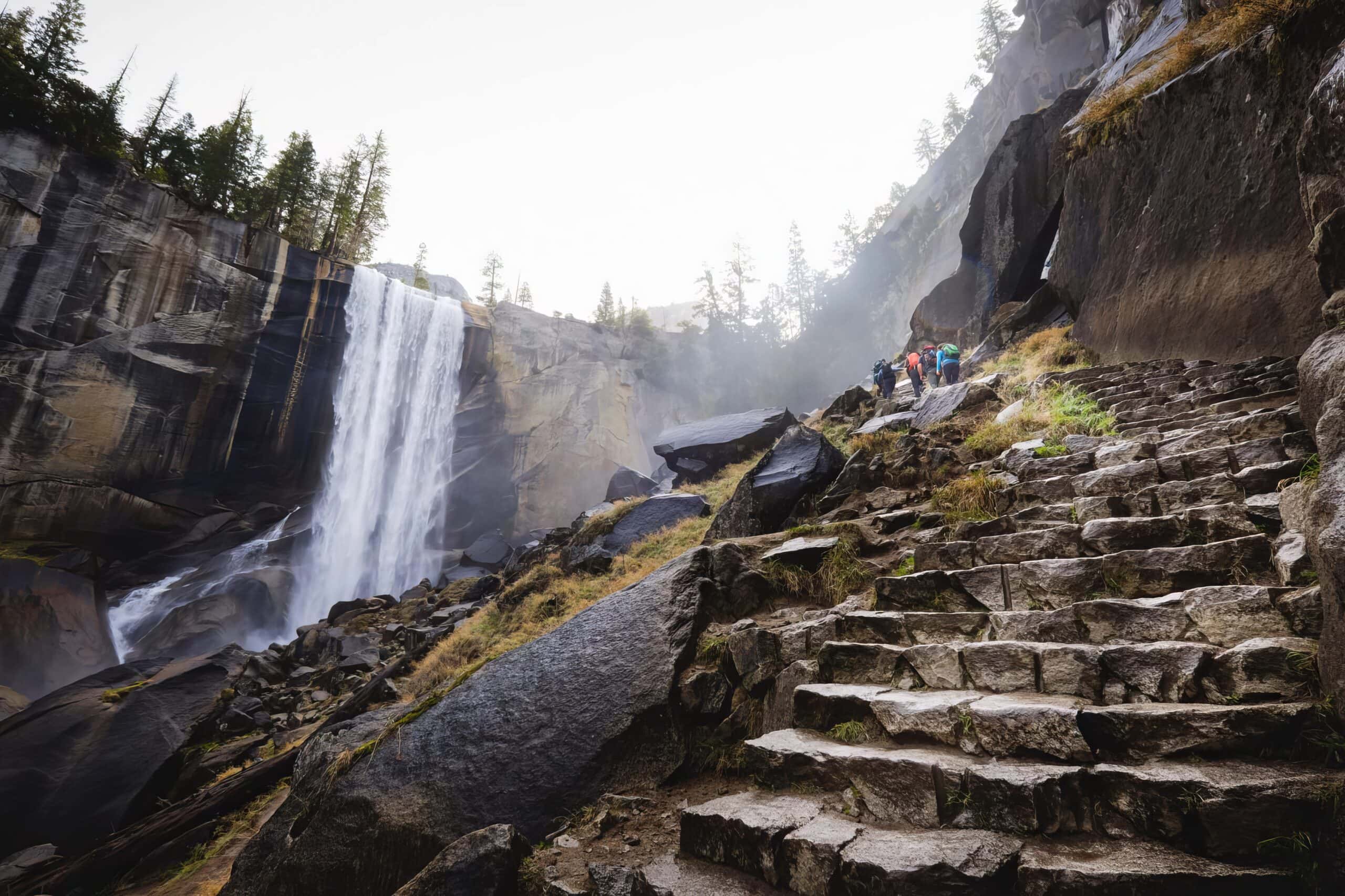
Maya Whitfield’s honest take: “The Mist Trail is the one hike I tell everyone to do in Yosemite, even if they only have one day. Go at 7 a.m. By 10 a.m. the staircase is a single-file line.”
Best for
- Waterfalls: Mist Trail, Yosemite
- Alpine scenery: Skyline Trail, Mount Rainier
- Coastal backpacking: Kalalau Trail, Kauai
Worth considering
- Eagle Creek Trail, Oregon: Waterfall alley in the Columbia River Gorge
- Lost Coast Trail, California: Remote coastal backpacking with tide charts required
What Are the Best Hiking Trails in the Southwest?
The Southwest is where the permit system matters most. Angels Landing, the Wave, and Havasu Falls all use lotteries or advance reservations. Plan these months ahead or look for alternatives.
Angels Landing, Zion National Park, Utah
Angels Landing is 5.4 miles round-trip with 1,500 feet of gain and a chain-assisted section across a narrow sandstone ridge. It is the most famous day hike in the Southwest and one of the most dangerous. The National Park Service issues permits through an online lottery, and demand far exceeds supply in peak season. If you cannot get a permit, hike to Scout Lookout instead. You get 90 percent of the view without the chain section.
Bright Angel Trail, Grand Canyon, Arizona
The Bright Angel Trail descends 7.8 miles from the South Rim to the Colorado River, with 4,380 feet of elevation loss on the way down. Most day hikers turn around at the 3-Mile Resthouse or Havasupai Gardens. The biggest mistake people make is underestimating the climb back up. It is twice as hard as the descent. No permit is needed for day hiking, but overnight trips into the canyon require a backcountry permit.
The Wave, Coyote Buttes North, Utah-Arizona Border
The Wave is a 6-mile round-trip hike through surreal sandstone formations. It requires a permit, which is issued by the Bureau of Land Management through two lottery systems, one online four months ahead and one in-person the day before. Permit odds are low, and there is no alternative nearby that looks the same. If you get a permit, bring more water than you think you need.
Maya Whitfield’s honest take: “If you cannot get an Angels Landing permit, do not skip Zion. The Observation Point trail is longer and harder, but the view is arguably better, and no lottery.”
What Are the Best Hiking Trails in the Rockies?
The Rockies are the highest and most demanding trails in the Lower 48. Elevation is the great equalizer here. If you live at sea level, plan two days of acclimatization before any trail above 9,000 feet.
Mount Elbert, Colorado
Mount Elbert is the highest peak in the Rockies at 14,440 feet. The standard route from the North Mount Elbert Trailhead is 9.5 miles round-trip with 4,700 feet of gain. It is not technical, but the altitude will hit you hard if you are not acclimatized. Start before sunrise to avoid afternoon thunderstorms, which are common in summer. No permit is required, but parking fills up by 5 a.m. in July and August.
Grinnell Glacier Trail, Glacier National Park, Montana
Grinnell Glacier is a 10.6-mile round-trip hike with 1,600 feet of gain through some of the most dramatic alpine scenery in the country. The trail passes two glacial lakes and ends at a shrinking glacier. Glacier National Park requires a vehicle reservation during peak season, but no hiking permit is needed for this trail. Bear spray is essential, and groups of four or more are recommended.
Emerald Lake, Rocky Mountain National Park, Colorado
Emerald Lake is the beginner-friendly hike in Rocky Mountain National Park. It is 3.6 miles round-trip with 700 feet of gain, starting from the Bear Lake trailhead. Along the way you pass Nymph Lake and Dream Lake, both photogenic. Go at sunrise to get the reflection on the water without the crowds. A timed-entry reservation is required to enter the park in peak season.
What Are the Best Hiking Trails on the East Coast and Appalachians?
The East Coast does not have the altitude of the Rockies, but it has humidity, roots, rocks, and steep granite. The trails feel longer than the mileage suggests.
Franconia Ridge Loop, New Hampshire
The Franconia Ridge Loop climbs Mount Lafayette, Mount Lincoln, and Little Haystack on an 8.9-mile loop with 3,900 feet of gain. Most of the upper section is above treeline, which means you are fully exposed to wind and weather. The views are the best in the White Mountains on a clear day. Do not attempt it in high winds or storms. The descent via Falling Waters Trail is steep and hard on the knees.
Old Rag Mountain, Shenandoah National Park, Virginia
Old Rag is a 9.4-mile loop with 2,300 feet of gain. The signature section is a rock scramble where you use your hands to climb through crevices and over boulders. It is the most popular hike in Shenandoah and now requires a day-use ticket from March through November. Buy the ticket online before you go.
Mount Katahdin, Baxter State Park, Maine
Katahdin is the northern terminus of the Appalachian Trail and the most demanding day hike in the Northeast. The Hunt Trail is 10.4 miles round-trip with 4,200 feet of gain and sections of above-treeline rock scrambling. Baxter State Park limits daily access, and you must reserve a parking spot in advance. The park is intentionally low-development. There is no cell service in most of it.

What Are the Best Long-Distance Hiking Trails in the USA?
Long-distance trails require a different kind of planning. You are not just picking a route. You are planning resupply points, water sources, and a window of two to six months.
Appalachian Trail (A.T.)
The A.T. runs 2,190 miles from Springer Mountain, Georgia, to Mount Katahdin, Maine. A thru-hike takes five to seven months, usually starting in Georgia in March or April to finish in Maine before cold weather arrives. The A.T. is the most accessible long trail in the country because it passes through towns every few days, making resupply easy. Permits are required in Great Smoky Mountains National Park and Baxter State Park. Registration is free for thru-hikers.
Pacific Crest Trail (P.C.T.)
The P.C.T. runs 2,650 miles from the Mexico border to Canada, through California, Oregon, and Washington. A full thru-hike takes four to six months. The trail passes through desert, alpine, and temperate rainforest. The biggest challenge is water management in Southern California and snow in the Sierra Nevada. Permits are managed by the Pacific Crest Trail Association through a lottery that opens in January. Long-distance permits are limited and sell out fast.
Continental Divide Trail (C.D.T.)
The C.D.T. runs 3,100 miles from Mexico to Canada along the spine of the Rocky Mountains. It is the longest, wildest, and least-developed of the three Triple Crown trails. Navigation is more challenging, resupply is harder, and the trail is less consistently marked. A thru-hike takes five to six months. Permits vary by section, with New Mexico and Glacier National Park requiring separate reservations.
How Do You Get Permits for Popular US Hiking Trails?
Apply months ahead for the big-name trails.
Angels Landing, Half Dome, Mount Whitney, and The Wave all use advance lotteries or reservations. The Wave lottery opens four months ahead. Half Dome is open in March for the whole season. If you are planning a trip around one of these trails, mark the lottery date on your calendar and apply the day it opens.
Check the official source, not a third party.
Permits for national parks are issued through Recreation.gov. Permits for Bureau of Land Management land, like The Wave, go through the BLM site. Do not buy permits from resellers. They are not valid.
Have a backup plan
If you do not get the permit, do not cancel the trip. Every trail on this list has an alternative within driving distance that does not require a lottery. Observation Point instead of Angels Landing. The John Muir Trail section instead of the full Pacific Crest Trail. The Northeast Rim instead of the Bright Angel Trail.
See the official National Park Service and Recreation.gov sites for current permit rules, fees, and lottery windows.
What Are the Biggest Mistakes Hikers Make on US Trails?
- Underestimating elevation. A 5-mile trail at 10,000 feet is harder than a 12-mile trail at sea level. Acclimatize first.
- Starting too late. Afternoon thunderstorms are common in the Rockies and Southwest from June to September. Start at sunrise.
- Not checking the permit requirements. Showing up at Zion without an Angels Landing lottery ticket means turning around.
- Bringing the wrong footwear. Trail runners work on dry trails. You need hiking boots or sturdy shoes for rock scrambles and wet granite.
- Carrying too little water. Plan one liter per person per two hours of hiking in desert and alpine conditions. More in extreme heat.
- Skipping the ten essentials. Navigation, sun protection, insulation, illumination, first aid, fire, repair kit, nutrition, hydration, and emergency shelter. Every time.
- Leaving trash or food scraps. This is a Leave No Trace violation, and it harms wildlife. Pack out everything you bring in.
Frequently asked questions about US hiking trails
What is the best hiking trail in the US for beginners?
The Mist Trail to the Vernal Fall footbridge in Yosemite is the best beginner trail. It is 1.6 miles round-trip with 400 feet of gain and gives you a waterfall view. Emerald Lake in Rocky Mountain National Park is another excellent option at 3.6 miles with gentle elevation gain.
Which US hiking trails require permits?
Angels Landing, Half Dome, Mount Whitney, and The Wave all require permits. The Kalalau Trail and Bright Angel Trail require permits for overnight trips. The Old Rag hike in Shenandoah requires a day-use ticket from March through November. Check Recreation.gov for current rules.
What is the best time of year to hike in the US?
It depends on the region. The Southwest is best from March to May and October to November. The Rockies are best from July to September. The Pacific Northwest is best from July to early October. The Northeast is best from late May to early October. Avoid summer afternoons in the Southwest due to heat.
How do I prepare for high-elevation hiking?
Arrive at altitude two days before any trail above 9,000 feet. Drink more water than usual, avoid alcohol on the first night, and start with a short trail before attempting a summit. If you feel a headache, nausea, or shortness of breath that does not improve with rest, descend immediately.
What should I bring on a day hike?
The ten essentials: navigation (map and compass or downloaded maps), sun protection, insulation, illumination (headlamp), first aid, fire starter, repair kit, extra food, extra water, and emergency shelter. On any trail above treeline, add a windproof shell and gloves.
Are dogs allowed on US hiking trails?
It depends. Most national parks do not allow dogs on trails, including Yosemite, Zion, and Glacier. National forests and Bureau of Land Management land generally do allow dogs on leashes. Always check the specific land manager’s rules before you go.
How can I find hiking trails near me?
Use the AllTrails app for the widest trail database with filters for distance and difficulty. For official information, check the National Park Service site for parks near you or your state’s Department of Natural Resources. Always verify trail conditions on the official site before you go.
Plan your trip: booking platforms we trust
These are the platforms I use to plan hiking trips around the US. I always cross-check the hotel or tour operator’s own site against at least one of these before paying.
Booking.com
Best for finding hotels and lodges near major trailheads and national parks.
Vrbo
Good for renting a cabin near trailheads in Colorado, Utah, and the Appalachians.
Kayak
Useful for comparing flights to gateway airports near national parks.
Expedia
Good for bundling flights and car rentals for a national park road trip.
GetYourGuide
Best for booking guided hikes and shuttle services in national parks.
TripAdvisor
Essential for reading recent trail reviews and hotel options near trailheads.
For more planning help, see our travel planning guides, our hotel reviews, our attractions section, and our visa category. When you are ready to book, start with our discounted flights page.
WakaAbuja does its best to keep all information accurate at the time of publishing. Prices, policies, and availability change regularly. Always verify with official sources before you travel. We are not liable for errors caused by outdated information. Travel insurance is strongly recommended.