advertisement
Peak District National Park: A Complete First-Timer’s Guide
Fact-Checked By: Maya Whitfield, Senior Travel Editor at WakaAbuja — Senior Travel Editor at WakaAbuja
The Peak District National Park covers 555 square miles across five counties in central England, making it the UK’s first national park (established 1951). It’s split into two distinct landscapes: the Dark Peak’s gritstone moorlands in the north and the White Peak’s limestone valleys and dales in the south. Best visited May to September for walking weather, with Manchester 45 to 75 minutes away and Sheffield just 30 to 60 minutes by car or train.
The Peak District doesn’t have a single dramatic peak. It has 555 square miles of gritstone edges, limestone dales, and stone villages, and figuring out where to actually go is the hard part. This guide cuts through the noise with a clear breakdown of what each area offers, how to get there from the major cities on its doorstep, and a realistic plan for your first visit.
Jump to: What and where | Dark Peak vs White Peak | Top highlights | Getting there | Best time to visit | First-timer plan | FAQ
Key takeaways
- The Peak District covers 555 square miles (1,438 sq km) across five counties: Derbyshire, Cheshire, Staffordshire, Yorkshire, and Greater Manchester.
- It was Britain’s first national park, established in 1951, and sits in the heart of England between Manchester and Sheffield.
- The park splits into two distinct landscapes: Dark Peak (gritstone moorlands in the north) and White Peak (limestone valleys and dales in the south).
- Top highlights include Kinder Scout (highest point at 2,088 feet), Mam Tor ridge walk, Dovedale’s stepping stones, Stanage Edge for climbing, Bakewell for pudding, and Castleton’s show caves.
- The best visiting window is May to September, with late June to early July offering the longest days (nearly 17 hours of daylight) and warmest weather.
- Getting there is straightforward: 45 to 75 minutes from Manchester, 30 to 60 minutes from Sheffield, 90 minutes from Birmingham or Leeds by car or train.
- Entry to the national park is free, but parking, attractions, and accommodation have separate costs (verify current parking fees with local councils).
What is the Peak District and where is it located?
The Peak District National Park sits in the center of England, at the southern end of the Pennines, the upland spine that runs down northern England. Despite its name, there are no actual peaks here. The name comes from the Pecsaetan, an Anglo-Saxon tribe that inhabited the area, not from mountain summits.
The park covers 555 square miles (1,438 square kilometers), which is roughly the size of Greater London, and reaches into five counties: Derbyshire (where most of it sits), Cheshire, Staffordshire, South and West Yorkshire, and Greater Manchester (verify boundary details with the Peak District National Park Authority). About 20 million people live within an hour’s drive, making it one of the most accessible national parks in the world (confirm visitor statistics with the official park website).
Established on 17 April 1951, the Peak District was the first national park in the United Kingdom, created to protect this distinctive upland landscape and ensure public access for recreation (verify establishment date with the National Park Authority). It’s managed by the Peak District National Park Authority, a government body responsible for conservation, planning, and visitor services across the designated area (check the current management structure on peakdistrict.gov.uk).
Maya’s honest take: “The ‘Peak’ in the Peak District confuses everyone on their first visit. Think of it as a cultural region name, not a geographic description. You’re here for edges, dales, and villages, not towering summits.”
Quick facts at a glance
- Area: 555 square miles (1,438 sq km) in the center of England (verify with the Peak District National Park Authority).
- Counties: Derbyshire, Cheshire, Staffordshire, South and West Yorkshire, and Greater Manchester (check boundary maps on the official website).
- Established: 17 April 1951, Britain’s first national park (confirm establishment date with official sources).
- Highest point: Kinder Scout at 2,088 feet (636 metres) in the Dark Peak (verify elevation with Ordnance Survey data).
- Population on doorstep: Approximately 20 million people within one hour’s drive (check current statistics with the National Park Authority).
What makes it unique?
- First national park in the UK, setting the model for all others that followed (verify historical significance with the National Park Authority).
- Two completely different geological landscapes side by side: gritstone moorlands and limestone dales (confirm geology with the British Geological Survey).
- Extensive cave systems in the White Peak, including commercial show caves open to visitors (check cave locations with local tourism boards).
- Historic market towns like Bakewell and Castleton with centuries-old buildings and traditions (verify heritage sites with local councils).
What’s the difference between the Dark Peak and White Peak?
The Peak District is a national park of two halves, split by geology into the Dark Peak and the White Peak. This isn’t just a marketing distinction. The underlying rock type determines everything you’ll see and do: the color of the landscape, the shape of the hills, the type of walking, and even the building materials in the villages.
The Dark Peak forms an arc across the north, east, and west of the park. It’s dominated by gritstone, a coarse sandstone also called millstone grit, which creates dark, moody moorlands, peat bogs, and dramatic rocky edges like Stanage and Kinder (verify geological details with the British Geological Survey). The name comes from the dark hues of the peat and exposed rock, not from any lack of light. Much of the Dark Peak is uninhabited open moorland, with reservoirs in the valleys and a few scattered villages on the fringes (check land use maps with the National Park Authority).
The White Peak covers the central and southern areas, built on a limestone plateau that’s been carved by water into steep-sided dales, caves, and gorges (confirm geology with official park resources). The landscape is greener and more pastoral, with ash woodlands, hay meadows, and stone villages built from the local limestone. Walking here means valley floors, riverside paths, and gentle climbs out of dales, rather than the big, exposed traverses of the Dark Peak (verify trail types with local walking guides).
Maya’s honest take: “If you only have one day and love big views, head to the Dark Peak around Edale or Castleton. If you prefer gentle valley walks, caves, and pretty villages, spend your time in the White Peak around Dovedale and Bakewell.”
Dark Peak highlights
- Kinder Scout and the Kinder Plateau for big moorland walks and Kinder Downfall waterfall (verify trail conditions with the National Park Authority).
- Stanage Edge for climbing and views, accessible from Hathersage (check climbing access with the British Mountaineering Council).
- Mam Tor ridge walk near Castleton, known as the ‘Shivering Mountain’ due to landslips (confirm trail status with local walking guides).
- Reservoirs like Ladybower and Derwent, with dramatic dams and moorland backdrops (verify access with water authority websites).
- Edale, the start of the Pennine Way, with direct train access from Manchester (check train schedules with Northern Rail).
White Peak highlights
- Dovedale with its limestone ravines, riverside walks, and famous stepping stones across the River Dove (verify access with the National Trust).
- Castleton’s four show caves: Peak Cavern, Speedwell Cavern, Treak Cliff Cavern, and Blue John Cavern (check opening times with cave operators).
- Bakewell for the original Bakewell Pudding, historic market square, and access to the Monsal Trail (confirm bakery recommendations with local tourism boards).
- Chatsworth House, the grand stately home with gardens and farmyard, near Baslow (verify opening seasons with the Chatsworth website).
- The Monsal Trail and Tissington Trail for traffic-free cycling and walking on old railway lines (check trail conditions with Derbyshire County Council).
What are the must-see places in the Peak District?
With 555 square miles to explore, narrowing down to a manageable list is the real challenge. These are the highlights that consistently deliver for first-time visitors, mixing iconic landscapes with practical access and a range of activities.
Kinder Scout is the highest point in the Peak District at 2,088 feet (636 metres), and it delivers the most dramatic moorland scenery in the Dark Peak (verify elevation with Ordnance Survey). The Kinder Plateau is a vast, peat-covered expanse with the iconic Kinder Downfall waterfall, which can blow back on itself in strong winds. Approaches from Edale or the Snake Pass offer different challenges, with the plateau itself requiring good navigation in poor visibility (check trail conditions with the National Park Authority).
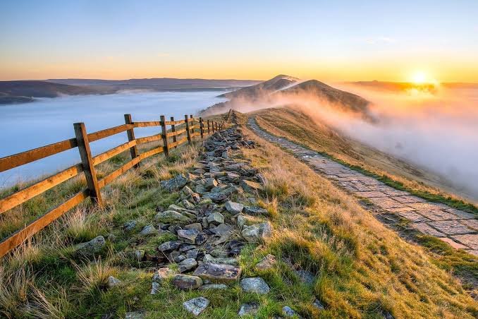
Mam Tor, meaning ‘Mother Hill,’ rises 517 metres near Castleton and is known locally as the ‘Shivering Mountain’ because of the frequent landslips on its eastern face (verify local name origins with Derbyshire tourism boards). The ridge walk from Mam Tor to Lose Hill is one of the most-loved short hikes in the park, with panoramic views over the Hope Valley and the limestone dales below (confirm trail length and difficulty with walking guides).
Dovedale sits at the southern end of the national park and is a magnet for visitors drawn to its limestone ravines, riverside walks, and the famous stepping stones across the River Dove (verify access with the National Trust, which manages much of the dale). It’s particularly popular in summer, so weekday visits or early starts help avoid crowds (check parking availability with Staffordshire County Council).
Maya’s honest take: “Dovedale’s stepping stones are Instagram-famous and can be queues-in-summer famous too. If you want the photo without the crowd, go on a weekday morning in May or September, not a sunny Saturday in July.”
Stanage Edge is the longest gritstone escarpment in the Peak District, stretching for about 3 miles and offering some of the best traditional climbing in Britain (verify climbing grades with the British Mountaineering Council). Even if you’re not a climber, the top of the edge provides sweeping views over the Dark Peak moorlands, and it’s easily accessible from Hathersage or Sheffield (check parking options with the National Park Authority).
Bakewell is the market town that gives its name to the Bakewell Pudding (not to be confused with the later Bakewell Tart), and it’s a perfect base for White Peak exploration (verify pudding history with local heritage organizations). The historic market square, independent shops, and riverside walks along the River Wye make it a pleasant stop even if you’re not doing big hikes (confirm market days with Bakewell town council).
Castleton sits in the Hope Valley beneath Mam Tor and is famous for its four show caves, medieval castle ruins, and access to some of the best Dark Peak walking (verify cave opening times with individual operators). The village is compact enough to explore on foot, with plenty of cafes and pubs, and train access from Sheffield makes it feasible as a day trip (check train schedules with Northern Rail).
Best for first-time visitors
- Mam Tor ridge walk for iconic views with moderate effort (verify trail conditions with walking guides).
- Dovedale stepping stones and riverside walks for gentle, scenic hiking (check access with the National Trust).
- Castleton’s show caves and village exploration for a mix of geology and culture (confirm cave tours with operators).
- Bakewell for food, shopping, and easy access to the Monsal Trail (verify trail status with Derbyshire County Council).
- Stanage Edge for climbers and non-climbers wanting dramatic gritstone scenery (check climbing access with the BMC).
Worth considering for longer stays
- Kinder Scout plateau and Kinder Downfall for serious moorland hiking (verify navigation requirements with the National Park Authority).
- Chatsworth House and gardens for stately home enthusiasts (check opening seasons with the Chatsworth website).
- The Monsal Trail and Tissington Trail for traffic-free cycling and walking (confirm trail conditions with local councils).
- Ladybower and Derwent reservoirs for dramatic dams and moorland scenery (verify access with water authority websites).
- Edale as a base for Pennine Way walking and Dark Peak exploration (check accommodation availability with local tourism boards).
How do you get to the Peak District from major cities?
The Peak District’s central location is its biggest advantage. You can reach the park boundaries from Manchester, Sheffield, Derby, or Nottingham in under 90 minutes, and the heart of the Dark Peak is even closer (verify travel times with National Rail Enquiries).
From Manchester: The distance from central Manchester to the edge of the National Park is about 36 miles, taking 45 minutes to an hour by car in normal traffic, or 45 minutes off-peak from south Manchester (verify current road conditions with Highways England). By train, Manchester Piccadilly runs hourly services direct into the Dark Peak: Edale is 44 minutes, Hope (for Castleton) is about 50 minutes, Hathersage (for Stanage Edge) is about 55 minutes, and Buxton is 65 minutes (check current schedules with Northern Rail).
From Sheffield: Sheffield is arguably the easiest major city base for Peak District access, with the park starting just 30 minutes from the city centre by car (verify driving times with local traffic reports). By train, Sheffield to Bamford or Edale takes approximately 20 minutes and costs around £5 to £8 one-way, making it feasible for spontaneous day trips (check current fares with National Rail Enquiries).
From Birmingham and Leeds: Both cities are about 90 minutes from the Peak District by car or train, making them viable bases for longer visits or weekend trips (verify journey times with National Rail Enquiries). Birmingham offers better motorway access via the M1 and M6, while Leeds connects via the M1 southbound (check current roadworks with Highways England).
Maya’s honest take: “If you’re relying on public transport, base yourself in Edale, Hope, or Hathersage for Dark Peak access, or Bakewell and Matlock for the White Peak. All have train or regular bus connections, and you can do serious walking without a car.”
Best transport options
- Train from Manchester Piccadilly to Edale, Hope, or Hathersage for Dark Peak walking (verify schedules with Northern Rail).
- Train from Sheffield to Bamford or Edale for quick, cheap access to the Hope Valley (check fares with National Rail Enquiries).
- Car for maximum flexibility, especially for White Peak villages and reservoirs (verify parking availability with local councils).
- Bus services from Sheffield to Castleton and other Hope Valley villages (check current routes with Stagecoach or TM Travel).
- Cycling the Monsal Trail or Tissington Trail for traffic-free White Peak exploration (verify bike hire with local operators).
Parking and access notes
- Popular car parks at Mam Tor, Dovedale, and Stanage Edge fill quickly on sunny weekends (verify capacity with the National Park Authority).
- Parking fees vary by location and council, typically £3 to £6 for a full day (check current rates with local council websites).
- Some remote trailheads have informal parking areas that are free but unmarked (verify access with walking guides).
- Consider park-and-ride options from Bakewell or Matlock for busy summer weekends (check availability with Derbyshire County Council).
- Winter conditions can close high routes like the Snake Pass between Manchester and Sheffield (verify road status with Highways England).
When is the best time to visit the Peak District?
The Peak District can be visited year-round, but your experience changes dramatically with the seasons. The ideal window for most visitors is May to September, when weather is most favourable for walking and outdoor activities (verify seasonal conditions with the Met Office).
@charlie.symonds Best time of year 👀 #kinderscout #peakdistrict #hiking #mountains #outdoors
Spring (March to May): The landscape awakens with wildflowers in the valleys and bluebells in the woodlands, making it ideal for walkers and photographers (verify wildflower seasons with the National Park Authority). Weather is unpredictable, with cool evenings requiring layers, but crowds are lighter than in summer, and lambing season adds character to the fells (check lambing times with local farms).
Summer (June to August): This is peak season, with the warmest weather, longest days (nearly 17 hours of daylight in late June), and the full lineup of festivals from well-dressed to the Buxton Opera Festival (verify festival dates with local tourism boards). Expect larger crowds, especially on weekends and during school holidays, and book accommodation in popular areas like Bakewell, Castleton, and near the Pennine Way well in advance (check availability with Booking.com).
Autumn (September to November): A spectacular time for photography, with forests and moorlands displaying autumn colors and cooler temperatures perfect for hiking (verify foliage timing with local walking guides). The Monsal Trail and Chatsworth gardens are particularly striking, and accommodation is easier to book than in summer (check opening times with Chatsworth House).
Winter (December to February): The landscape transforms with frost and occasional snow, offering peaceful walks and cosy countryside escapes (verify winter access with the National Park Authority). Daylight shrinks to under nine hours by November, and conditions on higher ground can be challenging with ice, snow, and strong winds (check weather forecasts with the Met Office). Some facilities close or operate reduced hours, so verify opening times before visiting (confirm with individual attractions).
Maya’s honest take: “Late June through early July is the sweet spot: you get nearly 17 hours of daylight, temperatures near 70°F, and the well-dressing festivals in full swing. Just pack a waterproof jacket, because July is also the wettest month with rain on roughly four out of ten days.”
Best for specific activities
- Walking and hiking: May to September for stable weather and long days (verify trail conditions with the National Park Authority).
- Photography: September to November for autumn colors, or March to May for wildflowers (check foliage timing with local guides).
- Climbing: April to October for dry gritstone, with Stanage and other edges in best condition (verify climbing conditions with the BMC).
- Cycling: May to September for the Monsal and Tissington Trails, with bike hire widely available (check bike rental with local operators).
- Cave visiting: Year-round, but summer offers longer days for combining with outdoor activities (verify cave opening times with operators).
Seasonal events and festivals
- Well Dressing festivals in villages across the White Peak, primarily June to August (verify dates with local parish councils).
- Buxton Opera Festival in July, with performances in the historic opera house (check the program with the Buxton Festival website).
- Bakewell Show in August, one of the oldest agricultural shows in the country (confirm dates with the Bakewell town council).
- Castleton Garland Day in May, a unique traditional ceremony dating back centuries (verify timing with the Castleton village website).
- Christmas markets in Bakewell, Buxton, and other towns in December (check dates with local tourism boards).
What’s a realistic first-timer’s itinerary for the Peak District?
Most first-time visitors try to cram too much in and end up spending more time in the car than on the trails. These itineraries focus on quality over quantity, with logical geographic groupings to minimize driving and maximize walking time.
One-day itinerary (Dark Peak highlights): Start early from Manchester or Sheffield, driving or taking the train to Edale (44 minutes from Manchester Piccadilly, 20 minutes from Sheffield) (verify train schedules with Northern Rail). Hike from Edale up to Kinder Scout via the Grindsbrook Clough path, returning via the Pennine Way for a 6 to 8-mile loop with big moorland views (check trail conditions with the National Park Authority). In the afternoon, drive or take the train to Castleton for a quick visit to one of the show caves (Peak Cavern or Speedwell are closest to the village), then grab dinner in the Hope Valley before heading back (verify cave opening times with operators).
Weekend itinerary (Dark and White Peak mix): Day one focuses on the Dark Peak with the Mam Tor ridge walk from Castleton, a classic 3 to 4-mile hike with panoramic views over the Hope Valley (verify trail length with walking guides). Spend the afternoon exploring Castleton’s caves and village, then drive to Bakewell for the evening (about 30 minutes via the A6187) (check road conditions with Highways England). Day two explores the White Peak with a morning walk in Dovedale, including the stepping stones and Thorpe Cloud viewpoint (2 to 3 miles, easy to moderate), followed by lunch in Bakewell and an afternoon on the Monsal Trail for traffic-free cycling or walking (verify trail access with Derbyshire County Council).
Maya’s honest take: “If you only have one day and the weather is good, do the Mam Tor ridge walk. It’s the most iconic short hike in the park, with views that punch well above its modest elevation. Save Dovedale for a second visit when you have more time.”
Where to base yourself
- Edale for Dark Peak hiking and Pennine Way access, with train connections from Manchester (check accommodation on Booking.com).
- Castleton for caves, Mam Tor walks, and Hope Valley exploration, with train access from Sheffield (verify hotel availability with local tourism boards).
- Bakewell for White Peak villages, the Monsal Trail, and food-focused visits (check B&B options on Hotels.com).
- Buxton for spa town amenities, opera festival access, and southern Dark Peak walks (verify spa hotels with Expedia).
- Matlock for Dovedale access, cycling the trails, and family-friendly attractions (check family hotels on TripAdvisor).
Essential packing list
- Waterproof jacket and layers, even in summer, due to rapidly changing conditions (verify weather forecasts with the Met Office).
- Sturdy walking boots with good grip for gritstone edges and limestone dales (check footwear recommendations with walking guides).
- Ordnance Survey Explorer OL1 (White Peak) and OL24 (Dark Peak) maps, or a GPS device with downloaded routes (verify map coverage with OS Maps).
- Headlamp for winter visits or early starts, with daylight limited to seven hours in December (check sunrise/sunset times with timeanddate.com).
- Water and snacks for longer walks, as villages can be sparse on the moorlands (verify water sources with walking guides).
Frequently asked questions
Is there an entrance fee for the Peak District National Park?
No, entry to the Peak District National Park is completely free, as it is for all UK national parks (verify with the Peak District National Park Authority). However, parking, attractions like show caves, and accommodation have separate costs, and some car parks charge £3 to £6 for a full day (check current parking fees with local council websites).
How big is the Peak District National Park?
The Peak District covers 555 square miles (1,438 square kilometres), which is roughly the size of Greater London (verify with the Peak District National Park Authority). It reaches into five counties: Derbyshire, Cheshire, Staffordshire, South and West Yorkshire, and Greater Manchester (check boundary maps on peakdistrict.gov.uk).
What’s the best base town for first-time visitors?
For Dark Peak hiking, Edale or Castleton offer the best trail access with train connections from Manchester and Sheffield (verify transport links with Northern Rail). For White Peak villages and gentle walking, Bakewell or Matlock provide central locations with good parking and amenities (check accommodation on Booking.com).
Is the Peak District dog-friendly?
Yes, the Peak District is very dog-friendly, with most footpaths, pubs, and many accommodations welcoming dogs (verify individual policies with businesses). Dogs must be kept under control around livestock, especially during lambing season from March to May, and some areas may have seasonal restrictions (check guidance with the National Park Authority).
Can you visit the Peak District without a car?
Absolutely. Train services from Manchester Piccadilly reach Edale, Hope, Hathersage, and Buxton, while Sheffield connects to Bamford and Edale (verify schedules with National Rail Enquiries). Bus services operate to Castleton and other villages, and the Monsal and Tissington Trails are accessible by public transport (check bus routes with Stagecoach or TM Travel).
What’s the difference between the Bakewell Pudding and Bakewell Tart?
The Bakewell Pudding is the original, dating back to the 1820s, with a shortcrust pastry base, jam layer, and an egg-and-almond filling (verify history with Bakewell heritage organisations). The Bakewell Tart is a later variation with a sponge topping and icing, more commonly found outside the town. For the authentic experience, try the pudding at the Old Original Bakewell Pudding Shop or other historic bakeries in Bakewell (check recommendations on TripAdvisor).
Are the Peak District caves suitable for children?
Yes, the four show caves in Castleton (Peak Cavern, Speedwell Cavern, Treak Cliff Cavern, and Blue John Cavern) offer family-friendly tours with varying levels of adventure (verify age restrictions with cave operators). Peak Cavern has the largest cave entrance in Britain and offers boat trips, while Speedwell features an underground canal boat ride (check opening times and prices on individual cave websites).
Plan your trip: booking platforms we trust
I’ve tested these platforms across dozens of UK trips for reliability, customer support, and real inventory. They’re not all right for every situation, but each one solves a specific problem better than the alternatives.
Booking.com
Widest selection of Peak District B&Bs, cottages, and hotels with free cancellation on most properties.
Hotels.com
Loyalty rewards program for repeat visitors booking Peak District hotels and country houses.
Expedia
Flight and hotel packages for trips combining Manchester or Birmingham airports with Peak District stays.
TripAdvisor
Real traveler reviews for Peak District pubs, restaurants, attractions, and accommodation.
GetYourGuide
Guided walking tours, cave visits, and cycling experiences in the Peak District with instant confirmation.
Kayak
Flight price comparison for routes into Manchester, Birmingham, or East Midlands airports.
More UK national parks and travel guides
If you’re planning a broader UK national parks trip or need more destination-specific advice, these guides cover the next steps in your itinerary.
- Hotels in the UK and Europe — budget to luxury accommodation guides with verified prices.
- Best things to do in the UK — from national parks to historic cities and coastal walks.
- Travel planning guides — itineraries, packing lists, and logistics for European trips.
- Visa requirements for the UK — entry rules, permitted stay lengths, and extension processes.
- How to find cheap flights to the UK — fare comparison strategies and booking timing tips.
WakaAbuja does its best to keep all information accurate at the time of publishing. Prices, policies, and availability change regularly. Always verify with official sources before you travel. We are not liable for errors caused by outdated information. Travel insurance is strongly recommended.