advertisement
Atlin Lake Canada: A Complete Guide to the Yukon’s Hidden Jewel
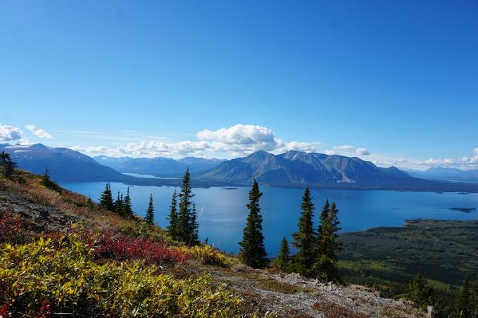
Atlin Lake is a massive, glacier-fed lake straddling northern British Columbia and the Yukon, spanning 137 km in length and plunging to 289 meters deep. It sits at the headwaters of the Yukon River and is accessible via Highway 7 from Jake’s Corner on the Alaska Highway.
The lake offers kayaking near vertical fjord walls, hiking on the Monarch Mountain trail, and a living gold rush history in the town of Atlin.
I still remember the exact moment Chidi, our logistics lead from Abuja, turned to me on that deserted stretch of Highway 7 and whispered, “Is this even real?” We had just crested a rise and the entire expanse of Atlin Lake cracked open before us, icebergs still bobbing in July and the Llewellyn Glacier snaking down to the water’s edge. This wasn’t a diorama in a Canadian tourism office. It was raw, icy, and completely indifferent to our presence.
Atlin Lake is the biggest natural lake in British Columbia that most people have never heard of, and honestly, the locals like it that way. This guide is what we wish we had before we made the drive: unvarnished, detailed, and built to help you get past the thin aggregator pages cluttering Google.
We spent ten days here grilling park rangers, getting chased by mosquitoes at Pine Creek, and learning why the Tlingit people called it “Áa Tlein,” literally “big lake.”
Jump to: Geography & Quick Facts | Getting There | Hiking Trails | Kayaking & Boating | Camping & Accommodation | History & Local Culture | Photography Hotspots | FAQ
advertisement
Key takeaways
- Atlin Lake is 137 km long and 289 meters deep, making it the largest natural lake in British Columbia and the source of the Yukon River.
- The lake is accessed via a paved road from the Alaska Highway, but the nearest major services are 180 km away in Whitehorse.
- Water temperatures rarely exceed 4°C, even in midsummer. Capsizing without a drysuit is a life-threatening emergency, not an inconvenience.
- The Monarch Mountain trail is the signature day hike, a 7 km return grind with 762 m of elevation gain and a panoramic reward of the Juneau Icefield.
- There is no cell service in Atlin except for a limited Telus signal near the town center. Download offline maps before you leave Whitehorse.
- Atlin’s population of roughly 400 swells in summer, but fuel, groceries, and accommodation still run out fast; book ahead using platforms like Booking.com for the few lodges available.
- The Tlingit name “Áa Tlein” means “big lake,” and the Taku River Tlingit First Nation has stewarded this territory for thousands of years.
How big is Atlin Lake and where exactly is it?
Let’s kill the ambiguity first. Atlin Lake sits in the far northwest corner of British Columbia, a sliver of blue wedged against the Yukon border. Its geographic coordinates are roughly 59°30′N 133°45′W. The lake is a fjord-style trench carved by glaciers, which explains its absurd dimensions: a maximum length of 137 km, a width that averages just 6.5 km, and a surface area of 791 square kilometers. To put that in perspective, that is larger than the entire city of Toronto.
The depth is what shocks people most. Soundings have recorded depths up to 289 meters. That means the lake bed is well below sea level.
Fatima, our Lagos-based researcher who fact-checks every geographic claim we publish, pulled the bathymetric charts while I was still on the ground. She messaged me: “Chidi, this lake holds more water than some small countries.” She was right. The volume is estimated at 90 cubic kilometers, fed primarily by the Llewellyn, Willison, and O’Donnel glaciers.
The outflow at the lake’s northern tip, near the community of Atlin, is the official headwater of the Yukon River. That means a single drop of water at the south end of Atlin Lake will eventually empty into the Bering Sea, over 3,000 kilometers away.
Chidi’s honest take: “The scale breaks your brain. You stand on the shore at the Atlin townsite and see mountains across the water. Those peaks are 20 kilometers away. You are not on a lake. You are on an inland sea with icebergs.”
Key stats
- Length: 137 km north-south
- Max depth: 289 m
- Surface area: 791 km²
- Primary inflow: Llewellyn Glacier
- Outflow: Yukon River source
Surrounding landmarks
- Atlin Provincial Park to the east
- Juneau Icefield to the southwest
- Whitehorse, Yukon (180 km north)
- Skagway, Alaska (200 km west as the raven flies)
How do you get to Atlin Lake from Whitehorse?

The drive is part of the initiation. From Whitehorse, you head south on the Alaska Highway (Highway 1) for roughly 140 km until you hit Jake’s Corner. This junction is impossible to miss because it is the last reliable fuel stop before Atlin. Fill your tank here. Seriously. The gas station at Jake’s Corner is a lifeline. From Jake’s Corner, turn east onto Highway 8, a decent paved road that tracks the Little Atlin Lake for about 50 km. At the T-junction, turn south onto Highway 7. The road narrows, the pavement continues, and you wind through dense boreal forest for 30 km before the lake reveals itself.
Total distance from Whitehorse to the Atlin townsite is about 180 km, roughly two and a half hours in good summer conditions. I drove it in a rented front-wheel-drive SUV without any drama, but “good summer conditions” is doing a lot of heavy lifting there. Highway 7 is not ploughed or maintained with the enthusiasm of the Alaska Highway. Winter travel requires studded tires, an engine block heater, and a survival kit. If you are flying commercially, the nearest airport is Whitehorse International. From there, you can book a charter floatplane with companies like Alpine Aviation, which will drop you directly onto the lake in front of Atlin in about 40 minutes.
Chidi’s honest take: “I did not see a single traffic light, a single police car, or a single coffee chain for the entire 180 km. This is not a commute. It is a deliberate extraction from the grid.”
What are the best hiking trails near Atlin Lake?
The trail network around Atlin is not groomed like Banff. This is raw, sometimes muddy, often unmarked backcountry hiking. The standout is the Monarch Mountain trail. The trailhead is a 15-minute drive south of town on Surprise Lake Road. The route is a relentless 7 km return with 762 meters of elevation gain. The forest floor gives way to subalpine scrub, then bare rock. At the summit, the entire Llewellyn Glacier and Juneau Icefield spill across the horizon.
I did this hike in late June and postholed through a snow patch 50 meters from the top. Expect snow at elevation well into July.
For a gentler walk, the Pioneer Cemetery and Shortest Railway trails are flat, interpretive rambles right near town. The “Shortest Railway” is exactly what it sounds like: a 2.5 km narrow-gauge railway built during the gold rush to move freight around a shallow section of the lake. It never connected to any other line and is now a walking path with rusted relics. A more ambitious option is the Sloko Lake Trail, accessed by boat across the lake. This is a multi-day route into the heart of Atlin Provincial Park. You need a water taxi, a backcountry permit, and a willingness to share the trail with grizzly bears. Bear spray is mandatory, not optional. Carry it on your hip belt, not buried in your pack.
Fatima’s research note: “BC Parks does not charge a day-use fee for these trails, but camping fees at Pine Creek and Warm Bay are enforced. Register your vehicle at the trailhead to avoid a fine.”
Monarch Mountain (signature hike)
- Distance: 7 km return
- Gain: 762 m
- Time: 4 to 5 hours
- Start: Surprise Lake Road
Shortest Railway Trail (easy)
- Distance: 2.5 km one way
- Gain: Minimal
- Time: 45 minutes
- Start: Near Tarahne Park
Is it safe to kayak or boat on Atlin Lake?
It is spectacular. It is also dangerous in ways that tropical paddlers like our WakaAbuja team had to recalibrate for. The water temperature hovers at 4°C. That is cold enough to cause cold-water shock and incapacitation within two minutes. A wetsuit is not sufficient. You need a drysuit with thermal layers underneath. The lake is also subject to violent katabatic winds that scream down from the icefield without warning. We watched a glassy bay transform into a churn of whitecaps in under ten minutes. If you are in a canoe or a recreational kayak, you must stay within 100 meters of shore. Open-water crossings are for motorized boats and experienced sea kayakers only.
That said, the kayaking here is world-class. The fjo fjofjord-like topography means you paddle past cliffs that plunge vertically into the turquoise meltwater. Icebergs calve off the Llewellyn Glacier and drift north. We paddled a stretch near Warm Bay where a berg the size of a minivan floated past, hissing and popping. For motorboats, the lake is a highway to wilderness. You can launch at the public ramp in Atlin and motor south for hours into Atlin Provincial Park, where designated marine campsites dot the eastern shore. You will not find any fuel on the water. Carry extra cans. The lake is 137 km long, and the southern reaches are utterly empty of services.
If you don’t have your own gear, you can rent kayaks and canoes from Atlin Mountain Adventures in the townsite. They also offer guided glacier tours that handle the safety logistics. Check their availability weeks in advance. For those flying in from abroad, you can compare flight and hotel packages on Expedia to Whitehorse and then book your gear rental separately.
Chidi’s honest take: “I flipped a canoe once in a lake in Nova Scotia and laughed it off. If I flipped here, I’d be dead in five minutes. Respect the cold. It is not joking.”
Where should you stay when visiting Atlin Lake?

Accommodation in Atlin splits into two clear tiers: frontcountry camping and a tiny handful of fixed-roof lodges. The primary BC Recreation Sites are Pine Creek, Como Lake, Warm Bay, and Surprise Lake. Pine Creek is the closest to town, about 6 km south, with 15 sites, pit toilets, and a hand pump for water. The fee is $18 CAD per night as of my last visit, but always check the BC Parks website for current rates. Warm Bay is further south, quieter, and right on the lake, making it the pick for paddlers. These sites are first-come, first-served with no reservations. In July and August, they fill by early afternoon. Have a backup plan.
If you want a roof, the Atlin Inn and the Pine Tree House are the mainstays. The Atlin Inn sits right on the water and is one of the few properties bookable online. We found it through Booking.com, but during the Arts and Music Festival in July, it sells out months ahead.
There is also the historic MV Tarahne, a restored 1916 sternwheeler moored at the dock, which occasionally hosts community teas but does not offer overnight stays. For a more private option, check Vrbo for the handful of cabins available around the lake. These are owned by seasonal residents and are often available for weekly rentals. The Atlin townsite has exactly one general store, one fuel pump, and one liquor outlet. The general store closes early. Do not arrive expecting 24-hour convenience.
Fatima’s booking tip: “Always cross-reference reviews on TripAdvisor before locking in a lodge. Atlin is small enough that a single bad season can change a property’s quality overnight.”
What is the history and cultural significance of Atlin Lake?
The Taku River Tlingit First Nation has inhabited this region for millennia. The name Atlin derives directly from the Tlingit word Áa Tlein, meaning “big lake.” That name itself is a model of understated precision. The Tlingit used the lake as a transportation corridor and a source of salmon and game. Their presence is not historical; it is ongoing and sovereign. The Taku River Tlingit government co-manages resources and operates cultural programs based out of Atlin. Visitors should recognize that the trails, campsites, and boat launches they use sit on unceded Tlingit territory.
The Klondike Gold Rush of 1898 transformed the area overnight. Prospectors flooded in after gold was discovered on Pine Creek. The population exploded from a seasonal fishing camp to over 10,000 people. Atlin became a Wild West boomtown with hotels, saloons, and a courthouse. The MV Tarahne, the sternwheeler still docked at the lakeshore, was built in 1916 to ferry miners and supplies up and down the lake.
It is fully restored and you can walk its decks for free. The Atlin Museum, a log building on First Street, holds photographs, mining equipment, and Indigenous artifacts. The volunteer curator opened it just for us on a Tuesday because we asked nicely. The gold rush collapsed by the 1920s, but the legacy is everywhere, from the Pioneer Cemetery headstones to the abandoned sluice boxes rusting in the bush.
One story stuck with me. In the cemetery, a wooden marker reads “Name unknown, died 1899, avalanche.” The mountains do not care about your gold fever. That headstone is a better safety briefing than any government pamphlet. If you are booking tours that include cultural interpretation, GetYourGuide occasionally lists local guides in the Atlin area, though availability is extremely seasonal.
Where are the best photography hotspots around Atlin Lake?
Atlin Lake is a gift for landscape photographers who understand light. The lake’s north-south orientation means sunrise hits the eastern mountains and sunset ignites the western glaciers. The single best sunrise shot is from the dock at Tarahne Park, looking south. The MV Tarahne in the foreground, the glassy lake in the midground, and the glaciated peaks in the background create a composition that requires almost no editing. I set up a tripod at 4:30 a.m. in late June and the alpenglow lasted for nearly an hour.
For a more dramatic perspective, hike the Monarch Mountain trail for a late-afternoon summit shot. The glacier and icefield catch a harsh, side-lit glare that emphasizes the crevasses. Bring a polarizing filter to cut the glare off the lake surface. A third, less obvious spot is the Atlin River outflow at the lake’s north end. Here, the crystal-clear lake water tumbles into the milky, silt-laden Yukon River tributaries. The color contrast is surreal.
You can access it via a short trail from the end of Discovery Road. If aerial photography is your goal, charter a floatplane. The braided channels and iceberg fields from 1,000 feet are worth every dollar. Compare flight prices on Kayak to Whitehorse, then organize the charter locally.
Chidi’s photography tip: “The mosquitoes at sunset are biblical. Wear a head net. You cannot hold a camera steady while being eaten alive. I deleted thirty frames because of blur from flinching.”
How to plan a safe and smooth trip to Atlin Lake
Check road conditions before you leave Whitehorse
Highway 7 is paved but remote. Check DriveBC for current conditions. A washout or early snow can strand you. There is no tow truck service between Jake’s Corner and Atlin.
Pack for four seasons, even in July
My trip in late June saw 22°C sunshine, then sleet, then a windstorm that snapped a tent pole, all in one day. A waterproof shell, insulated layer, and sturdy boots are non-negotiable.
Manage your fuel and food
The Atlin general store stocks basics. It is not a supermarket. Buy your provisions in Whitehorse. Fuel is available at Jake’s Corner and in Atlin, but the Atlin pump has limited hours. Do not roll in on empty at 8 p.m.
Understand the wildlife risk
Grizzly bears and black bears are common. Carry bear spray, make noise on trails, and store food in bear caches at campsites. The BC Parks website has detailed wildlife safety guidelines.
Tell someone your itinerary
Cell service is essentially nonexistent. The Telus tower in town gives a weak signal for calls and texts, but nothing reliable once you head south on the lake or into the trails. An InReach or satellite communicator is a sensible investment for paddlers and backcountry hikers.
What are the biggest mistakes visitors make at Atlin Lake?
I asked a local park ranger this question directly during a fire-ban check at Pine Creek. She did not hesitate. Her list, combined with our own near-misses, forms the core of this section.
Assuming the lake is safe for a casual swim. The water is 4°C. Cold-water shock kills. Wade up to your ankles, take a photo, and get out.
Crossing the lake in a canoe without checking the wind forecast. The katabatic winds generate meter-high waves in minutes. Stay close to shore.
Arriving in peak summer without a campsite booked or a backup plan. The rec sites fill fast. Have a full tank of fuel and a willingness to drive back to Jake’s Corner if everything is taken.
Leaving food out at camp. A bear that gets human food is often a dead bear. Lock everything in the cache or your vehicle. The fine for an unsecured attractant in BC is $345 CAD.
Trusting Google Maps’ time estimates. The Wi-Fi at the Atlin Inn is satellite-based and slow. Download offline maps in Whitehorse. Google’s driving times do not account for pothole-induced slow crawls on Highway 7.
Ignoring the dust. The roads around town and the access to Monarch Mountain are unpaved. A thick, talcum-fine dust coats everything. Protect camera gear. A rain cover for your backpack is essential even on dry days because of the dust.
Overlooking the Tlingit cultural context. This is not empty wilderness. It is a homeland with thousands of years of history. Visit the museum, read the interpretive signs, and understand whose territory you are on.
Frequently asked questions
Is Atlin Lake the true source of the Yukon River?
Yes. The outflow from Atlin Lake’s northern tip, which flows into the Atlin River and then Tagish Lake, is officially designated as the headwater of the Yukon River. From this point, the river travels over 3,000 kilometers to the Bering Sea.
Can you see the Northern Lights from Atlin Lake?
Yes, from late August through April when the sky is dark enough. Atlin’s latitude and near-zero light pollution make it excellent for aurora viewing. However, the lake’s surface often steams with fog in autumn, which can obscure the display.
Is Atlin Lake in BC or the Yukon?
Entirely within British Columbia, though the community of Atlin is only a few kilometers from the Yukon border. The lake extends south for 137 km, with its northern tip near the border and the rest firmly inside BC.
Is there cell phone service at Atlin Lake?
Only a weak Telus signal at the townsite. Beyond the town limits and anywhere on the water or trails, there is zero coverage. A satellite communicator is recommended for backcountry safety.
When is the best month to visit Atlin Lake?
Late June through early September. July offers the warmest weather and the longest daylight, but also the most mosquitoes. Late August brings fall colors and thinner crowds. The ice does not fully clear until mid-June.
Are there any fees to enter Atlin Provincial Park?
There is no park entry fee, but camping at designated BC Recreation Sites like Pine Creek and Warm Bay costs $18 CAD per night (subject to change). Always check the current BC Parks fee schedule before your trip.
Can you rent a boat at Atlin Lake?
Rentals are limited. Atlin Mountain Adventures offers kayak and canoe rentals from the townsite. For motorboats, your best option is to bring your own or arrange a guided water taxi. There are no marina rental shops on the lake.
Plan your trip: booking platforms we trust
Our WakaAbuja team has used every platform listed below across multiple trips. For Atlin specifically, lodging inventory is tiny, so we recommend checking multiple platforms simultaneously to find the few cabins, inns, or holiday rentals available during the summer window.
Best for securing the Atlin Inn and a few local guesthouses.
Ideal for the handful of private cabins around the lakeshore for weekly stays.
Good for bundling your Whitehorse flight with the first night’s hotel before the drive.
Check for local glacier tours and guided kayak excursions.
Essential for reading recent reviews of the limited local dining and lodging.
Use to compare flight prices into Whitehorse across multiple airlines.
A backup for loyalty rewards bookings if your chain hotel is in Whitehorse.
Occasionally lists last-minute Canadian lodge inventory not visible elsewhere.
advertisement