advertisement
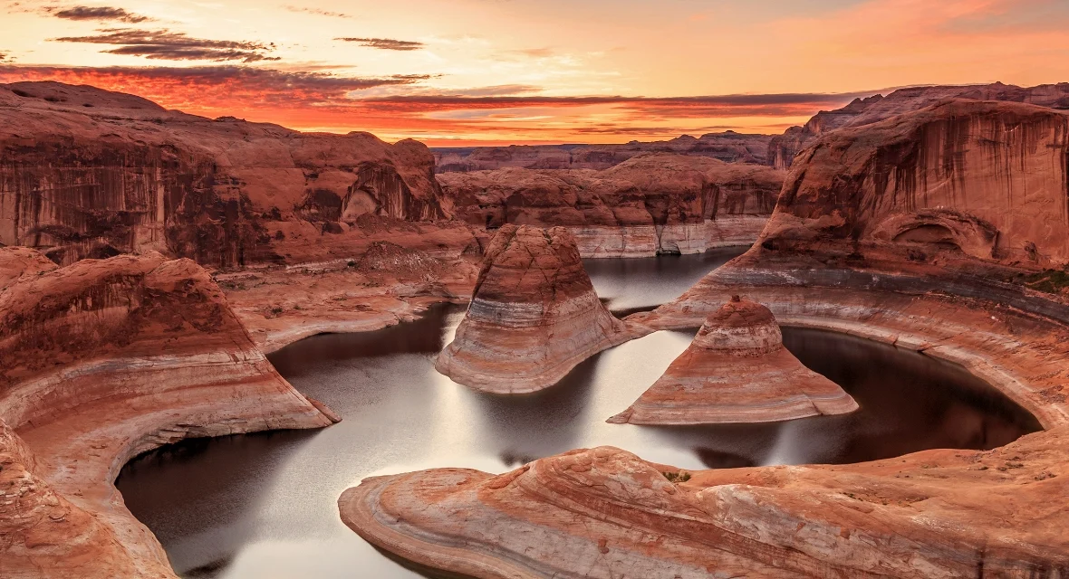
Lake Powell, Utah, is the second-largest man-made reservoir in the United States, formed by the Glen Canyon Dam on the Colorado River. It’s a massive water playground with over 1,900 miles of shoreline, famous for houseboating, water sports, and exploring red-rock canyons, straddling the Utah-Arizona border.
As of this year, water levels are a key concern for visitors, with the lake at about 23% of full capacity, so planning which marina to use is essential.
When we first laid eyes on Lake Powell, it was during a scorching July trip. We were driving from Page, Arizona, and the first glimpse of that electric blue water cutting through the dusty red desert felt like a mirage. We spent the next five days on a houseboat, exploring hidden canyons and swimming in water that felt like a warm bath. It’s a place that gets under your skin. But here is the truth: Lake Powell is not just about the stunning photos. It is a place that demands respect and planning. Water levels are not what they used to be, marinas are adapting, and the desert heat is relentless.
This guide is what we wish we had known before we went. It is everything you need to plan a trip to Lake Powell, Utah, right now, not just the history of the lake.
Jump to: Current Water Levels | Marina Comparison | Best Time to Visit | What It Costs | Mistakes to Avoid | FAQs
Key takeaways
- Plan your marina carefully: Lower water levels have changed access. Wahweap and Antelope Point are your best bets for reliable boat ramps.
- Book your boat rental early: Houseboats and powerboats book months in advance for peak summer (June-August).
- The water level is low: As of this year, Lake Powell is at roughly 23% capacity. This is the new reality, so your trip plan needs to be flexible.
- Pack for extreme conditions: Daytime summer temperatures regularly hit 100°F (38°C). Bring more water, sun protection, and shade than you think you need.
- Know the rules on waste: You must carry out all human waste. Portable toilets are mandatory for boat-in campers. No exceptions.
- You can camp for free: Beach camping is allowed on a first-come, first-served basis. It is one of the best ways to experience the lake.
What Is Lake Powell, and Where Is It in Utah?

Lake Powell is a reservoir on the Colorado River, straddling the border of Utah and Arizona. It was created by the Glen Canyon Dam, which was completed in 1963. It is the second-largest man-made reservoir in the U.S., after Lake Mead, and is the centerpiece of the Glen Canyon National Recreation Area, attracting around two million visitors annually.
For a visitor, the lake is a playground of epic proportions. It stretches 186 miles long and has a staggering 1,960 miles of shoreline when full—more than the entire West Coast of the United States This jagged coastline creates hundreds of hidden canyons, secluded beaches, and endless opportunities for exploration. The lake lies primarily in southern Utah, with its southern tip dipping into northern Arizona. Most visitors access it via the town of Page, Arizona, which is the main gateway to the southern marinas.
Sarah, our Denver correspondent’s honest take: “The scale of Lake Powell is what gets you. You think you are just going to a lake, but you are essentially looking at a flooded canyon system. It is a maze of water and rock. The first time we navigated it, I felt like an explorer. It is utterly unique.”
Current Water Levels: What to Expect This Year
This is the most critical question for any trip to Lake Powell right now. The lake level is not what it was a decade ago. As of late this year, the water elevation is roughly 3,524 feet above sea level, which is about 176 feet below its full pool of 3,700 feet. The lake is currently at about 23% of its total capacity, nearing a record low set in 2023. This is a direct result of the ongoing megadrought in the American Southwest and high water demand.
What does this mean for you? The most obvious impact is on boat ramps. Several marinas, like Bullfrog, have seen their ramps close or become unusable for larger vessels. The National Park Service notes that ‘lower lake levels have changed the availability of some services.’ You cannot just show up expecting to launch from anywhere. Your best options are Wahweap and Antelope Point marinas, which have maintained public launch ramps. Always check the official National Park Service’s Changing Lake Levels page for the most current conditions before you head out.
Best for access
- Wahweap Marina: The most reliable, full-service option near Page, AZ.
- Antelope Point Marina: Also a good bet with a public launch ramp.
- Halls Crossing: Has a ramp, but check conditions.
Worth considering
- Bullfrog Marina: Land-based services only as of late this year; the boat ramp is not viable for large boats [citation:3].
- Dangling Rope: Only accessible by water. Check if fuel and services are available.
Choosing Your Marina: Wahweap vs. Bullfrog vs. Antelope Point vs. Halls Crossing vs. Hite

Your choice of marina is the single most important planning decision. It dictates where you start, what services you have, and where you can explore. The lake is vast, and getting from one end to the other by boat can take an entire day. We spent a full day motoring from Wahweap to Rainbow Bridge and back, and it was a long trip. Here’s a breakdown of your main options.
Wahweap Marina
Location: 5.5 miles from Glen Canyon Dam, near Page, AZ.
Best for: First-timers and those wanting full services. It has lodging, restaurants, campgrounds, boat rentals, and a reliable boat ramp.
Our take: This is the ‘main hub’ and the easiest place to start your trip. It’s busy but offers everything you need.
Antelope Point Marina
Location: 6.5 km up the lake from the dam, off Highway 98.
Best for: Those seeking a newer, more luxurious marina with a unique floating restaurant and good access.
Our take: This marina is also in the ‘South Lake’ area and offers excellent access to the main channel and nearby slot canyons.
Bullfrog Marina
Location: North side of the lake, accessible via Utah Highway 276.
Best for: Visiting the quieter, northern end of the lake. However, the NPS states Bullfrog currently offers land-based services only due to low water.
Our take: A great area, but you cannot launch a boat here right now. You can still stay in the lodge and use other services.
Halls Crossing & Hite
Location: Halls Crossing is across from Bullfrog. Hite is at the far northeastern end.
Best for: Halls Crossing has a launch ramp. Hite is very remote, and services are severely impacted by low water.
Our take: For most visitors, Wahweap or Antelope Point are the smarter, safer choices for a stress-free trip.
Best Time to Visit Lake Powell
The best time to visit Lake Powell is either side of the intense summer heat. May and October are the ‘goldilocks’ months for most travelers, offering warm weather, comfortable water temperatures, and fewer crowds. Daytime highs in May are in the 70s and 80s (Fahrenheit), while October offers similar pleasant conditions.
Summer (June to September) is the most popular time, but it comes with serious heat. Temperatures frequently climb between 90 and 100°F (32 to 38°C), and July and August can bring sudden thunderstorms. However, summer is when the lake truly comes alive, with everyone on the water. The water temperature is warm, often reaching 80°F, which is perfect for swimming. If you can handle the heat, it is a fantastic time. Winter is quiet, with reduced facilities and cooler temperatures, but it can be a serene escape if you are prepared.
Jake, our team’s outdoor expert, says, “I will take the shoulder seasons every time. You get the perfect weather without the July crowds. The water is still warm enough to swim, and the evenings are magical. It is the sweet spot for a houseboat trip.”
What It Actually Costs: A Price Guide

Lake Powell is not a budget destination. A trip here requires a significant investment, so it is wise to know what you are getting into. The biggest cost is accommodation, which for many is a houseboat rental. Here is what you can generally expect.
- Houseboat Rentals: Prices vary wildly by season and size. A standard 50-foot houseboat that sleeps 10-12 people can cost anywhere from $3,000 to $6,000+ for a week during the peak summer season. Shoulder season rates are significantly lower. Always check with Lake Powell Resorts & Marinas for exact prices.
- Powerboat & Jet Ski Rentals: A 21-foot powerboat for a day can cost around $400-$600, while a jet ski rental is usually $100-$200 per hour.
- Park Entrance Fees: A 7-day vehicle pass for Glen Canyon National Recreation Area is $30. A single person on foot or bike is $15. An annual pass is $55.
- Lodging: Hotels in Page, Arizona, are the most common option outside of camping. Expect to pay between $150 and $400 per night, depending on the season and quality.
- Fuel: Marina fuel is expensive. On average, expect to pay 30-50% more than at a standard gas station.
Before you commit to any rental, it is crucial to verify current rates and availability directly with the official concessioner, Lake Powell Resorts & Marinas.
How to Plan Your Lake Powell Houseboat Trip
1. Book Early and Confirm Your Launch Ramp
Vessels book up months in advance for the peak summer season. Do not wait. When you book, you must confirm which marina you are launching from. With current low water levels, not all ramps are functional. Wahweap and Antelope Point are your safest bets.
2. Plan Your Provisions
Once you are on the lake, access to stores is limited. There are a few convenience stores at marinas, but they are expensive and have limited stock. We packed almost all our food, water, and supplies in Page. Plan every meal, bring plenty of drinking water (at least 1 gallon per person per day), and pack lots of snacks. As the NPS recommends, you must be self-sufficient.
3. Understand Waste Management
This is non-negotiable. If you are camping on a beach (which is allowed), you are required to have a portable toilet and you must pack out all of your human waste. Rangers do spot checks. A citation is not how you want to end your trip. The NPS website has a full list of regulations on waste management and fire restrictions.
4. Check the Ferry Schedule
If you are planning to move between Bullfrog and Halls Crossing, the Charles Hall Ferry is a useful shortcut. It is operated by the State of Utah, and service is not always guaranteed. Always call ahead at 435-893-4747 to verify it is running.
Mistakes First-Timers Make at Lake Powell
- Assuming you will have cell service. You will not in most of the lake’s canyons. Download offline maps, and tell someone your itinerary before you head out. This is a remote wilderness area.
- Underestimating the desert sun. The sun is relentless. We saw people with severe sunburns on day two of our trip. Bring a wide-brimmed hat, long-sleeved UV-protective clothing, and high-SPF sunscreen. Reapply it constantly.
- Not bringing enough water. You cannot drink lake water. The heat and physical activity will dehydrate you fast. A general rule is one gallon per person per day. Double that if you are hiking.
- Not checking the water level before arriving. This is a critical mistake. You cannot rely on old maps or guides. The NPS’s “Changing Lake Levels” page is your most important resource for planning where to launch and navigate.
- Ignoring the risk of flash floods in slot canyons. The canyons are beautiful, but they can become death traps in a sudden downpour. Always check the weather forecast for the entire region. If there is any chance of rain, do not enter a slot canyon.
- Failing to bring a portable toilet. You are required by law to have one if you are boat-in camping. Rangers will check. Do not try to bury your waste. It is illegal, bad for the environment, and will ruin the experience for others.
- Not bringing enough shade. The houseboat’s top deck can be an oven. Bring a pop-up canopy or at least a large tarp to create shade on the beach. This is as important as sunscreen.
Frequently asked questions
Is Lake Powell man-made?
Yes, Lake Powell is man-made. It is a reservoir created by the construction of the Glen Canyon Dam on the Colorado River, which was completed in 1963. It is often called a lake colloquially, but it is officially a man-made reservoir.
How deep is Lake Powell?
The maximum depth of Lake Powell is 583 feet (178 meters). Its average depth is around 132 feet (40 meters). The depth changes based on current water levels, which are significantly lower than the historical maximum.
Can you swim in Lake Powell?
Absolutely. Swimming is one of the most popular activities at Lake Powell. The water is clean and clear, and in the summer, it warms to around 80°F (27°C), which is perfect for swimming. However, there are no lifeguards, so you should always be cautious, wear a life jacket, and keep a close watch on children.
Can you camp on the beach at Lake Powell?
Yes, you can camp on almost any beach along the shoreline on a first-come, first-served basis. This is a fantastic way to experience the lake. However, it is primitive camping, so you must bring everything you need, including water, food, and shade. You are also required to have a portable toilet and pack out all human waste.
Is it safe to visit Lake Powell with low water levels?
Yes, it is safe, but it requires more planning. The low water levels mean you need to be careful about which marinas are accessible and watch out for shallow areas and newly exposed hazards while boating. Always consult the latest NPS resources and official charts for navigation.
How far is Lake Powell from Salt Lake City?
The drive from Salt Lake City, Utah, to the main gateway of Page, Arizona (near Wahweap Marina), is roughly 350 miles and takes about 6 hours. The closest major airport to the lake is Page Municipal Airport in Arizona.
Plan your trip: booking platforms we trust
For your Lake Powell adventure, we recommend starting with the official concessioner for lodging and rentals. Our team at WakaAbuja trusts these platforms to help you find the best deals on travel logistics and tours.