advertisement
Mount Rainier National Park: A Complete Guide to Washington’s Majestic Peak, Hiking Trails, Glaciers & Wildflower Meadows
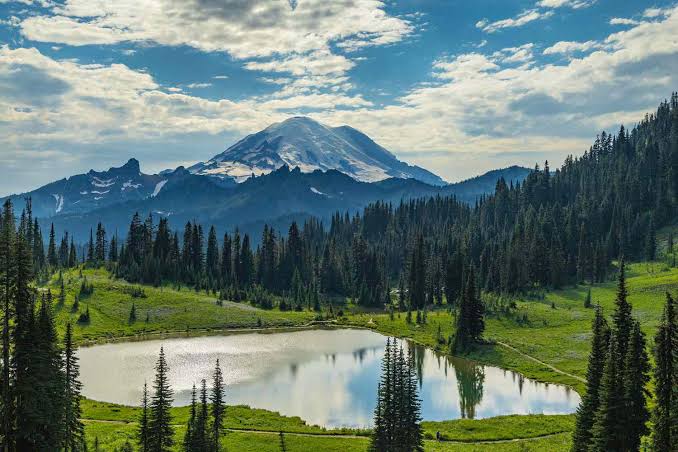
Mount Rainier National Park is a 236,381-acre wilderness centered on an active stratovolcano standing at 14,410 feet. The park features over 260 miles of maintained trails, 25 named glaciers, and subalpine meadows that erupt in wildflowers from mid-July through August.
Access is split across five distinct regions—Paradise, Sunrise, Longmire, Ohanapecosh, and Carbon River—each offering different trail difficulties, scenery, and seasonal windows.
I still remember the first time Fatima, our Lagos correspondent, sent a voice note from the Skyline Trail. She wasn’t breathless from the incline—she was speechless because a marmot had just stolen her trail mix straight from her backpack. That’s the thing about Rainier: the mountain sets the rules, and even the wildlife has an attitude.
Over the years, our WakaAbuja team has logged visits across every park quadrant, made every logistical mistake so you don’t have to, and developed a very specific love for the way Sunrise Road feels at 6 a.m. when the tarmac is still damp with fog.
This guide breaks down exactly what you need to know—no generic fluff, just trail-by-trail specifics, parking lot names, road status tricks, and the honest reality of sharing a national park with two million other visitors each year.
Jump to: Park Regions & Best Hikes | Wildflower Season Guide | Glaciers & Viewpoints | Logistics & Road Status | Itinerary Builder | Common Mistakes | FAQ
advertisement
Key takeaways
- Entry to the park costs $30 per vehicle for a 7-day pass; the America the Beautiful annual pass ($80) pays for itself in two visits if you are also hitting Olympic or North Cascades.
- Paradise and Sunrise are the two most popular regions, but they sit at opposite sides of the mountain—driving between them takes 2.5 hours via Stevens Canyon Road.
- Wildflower blooms peak between late July and mid-August at Paradise; Sunrise runs about two weeks later due to higher elevation.
- Cell service is virtually nonexistent across 90% of the park—download offline maps on Google Maps or AllTrails before you leave Ashford or Enumclaw.
- As of this year, Mount Rainier has no timed-entry reservation system, but parking lots at Paradise and Sunrise fill by 8:00 a.m. on summer weekends.
- Seven of the park’s 25 named glaciers are visible from the Paradise area alone—the Nisqually Glacier terminus is reachable on a paved 0.2-mile path from the visitor center.
- Overnight backcountry trips require a wilderness permit, available through Recreation.gov, and certain high-demand zones like Camp Muir fill weeks ahead for peak season.
Which park region should you visit first? Paradise vs. Sunrise vs. Longmire
@truenorthtraveller 📍MT. Rainier – paradise side Hike: Longmire to Carter Falls 6 mile out and back **make sure to check the national park website for conditions and road closures during the winter season #mountrainier #mtrainier #paradise #nationalpark #washingtonstate #pnw #winteradventures #winterhike #mountainlife #evergreens #backpack #northface #travelnurse #snowday #peakseason
Mount Rainier is not a drive-through park. Each of the five regions demands its own day, its own parking strategy, and its own trail legs. Chidi, who handles our Abuja-to-PNW travel logistics, splits them into two tiers: “frontcountry icons” (Paradise and Sunrise) and “deep cuts” (Longmire, Ohanapecosh, Carbon River). If you have only one day, pick exactly one region and commit—you will lose two hours trying to do both Paradise and Sunrise in a single push.
Paradise sits at 5,400 feet on the south slope and is the park’s gravitational center. The Henry M. Jackson Visitor Center stays open year-round, and the trail network here—Skyline Loop, Alta Vista, and Deadhorse Creek—runs directly into the mountain’s most photographed wildflower meadows. Sunrise, at 6,400 feet on the northeast side, offers higher-elevation views of the Emmons Glacier and a drier, rockier landscape that feels closer to alpine tundra.
The road to Sunrise (Sunrise Park Road) typically opens in late June and closes by mid-October, while Paradise is accessible year-round—weather permitting.
Chidi’s honest take: “Paradise on a clear Tuesday in late July is worth every parking headache. But if you arrive on a Saturday at 10 a.m., you will circle the lot for 40 minutes. I now tell everyone: the parking lot is full by 8 a.m., no exceptions. Set your alarm for 5:30 a.m. or aim for 3 p.m. arrival when the early crowd starts leaving.”
Best for first-timers
- Paradise: Year-round access, wildflower peaks, Skyline Trail, visitor center with exhibits.
- Sunrise: Best 360-degree summit views, fewer crowds on weekdays, access to the Burroughs Mountain trail.
- Longmire: Historic district, gentle Trail of the Shadows loop, accessible hot springs viewpoints.
Worth considering
- Ohanapecosh: Old-growth forest, Silver Falls loop, no mountain views—best for rainy days. The Grove of the Patriarchs suspension bridge remains closed for repairs.
- Carbon River: Rainforest ecology, least crowded quadrant, access to the Carbon Glacier trail.
What are the best hiking trails at Mount Rainier National Park by difficulty?
This is the question our team gets most in DMs. The honest answer: the “best” trail depends entirely on your fitness, your tolerance for elevation gain, and what month you are visiting.
A trail that is a five-star knockout in August can be a slushy, postholing nightmare in early July. Below is a breakdown by difficulty using exact mileage and elevation data from our own tracked hikes.
Easy trails (family-friendly, under 3 miles)
- Nisqually Vista Trail (Paradise): 1.2-mile paved loop, 200 ft gain, views of Nisqually Glacier. Wheelchair accessible.
- Trail of the Shadows (Longmire): 0.7-mile loop, flat, interpretive signs on pioneer history and mineral springs.
- Silver Falls Loop (Ohanapecosh): 3 miles round trip, 300 ft gain, passes a dramatic waterfall through old-growth cedar forest.
Moderate trails (3 to 7 miles)
- Skyline Trail Loop (Paradise): 5.5 miles, 1,700 ft gain. The park’s marquee hike—waterfalls, marmots, and panoramic Rainier views—is a must-do.
- Burroughs Mountain (Sunrise): 4.7 miles to First Burroughs, 900 ft gain. Straight-on Emmons Glacier views.
- Rampart Ridge Loop (Longmire): 4.6 miles, 1,300 ft gain. Less crowded alternative with summit views on clear days.
Strenuous trails (7+ miles, major elevation)
- Camp Muir (Paradise): 9 miles round trip, 4,600 ft gain. A non-technical snow climb to base camp at 10,188 ft. Requires glacier travel awareness above Pebble Creek.
- Summerland to Panhandle Gap (Sunrise side): 12 miles round trip, 3,000 ft gain. Alpine tundra, resident mountain goats, and the park’s highest maintained trail point at 6,800 ft.
A note from Fatima: “I did Skyline clockwise on a sunny August morning and the wildflowers were so thick I could smell them before I could see them. Counterclockwise is steeper but gets the exposed ridgeline section done earlier. Clockwise saves the best panorama for the back half.”
When is the best time to see wildflowers at Mount Rainier?
The short window: mid-July through the third week of August, with the absolute peak typically landing around the first week of August. But elevation matters enormously. Paradise meadows at 5,400 feet melt out and bloom first. Sunrise, at 6,400 feet, runs 10 to 14 days behind. As of early this year, the snowpack levels were near average, which typically produces a strong bloom rather than the muted showing seen in heavy-snow years when melt is delayed into late August.
What you are actually seeing: avalanche lilies appear first, often pushing through lingering snow in late June. Magenta paintbrush, purple lupine, and white bistort follow in July. By early August, the meadows are a carpet of dozens of species. Specific hot spots include the Alta Vista trail (a short 1.7-mile side loop from Paradise), the Skyline Trail’s lower third, and the Berkeley Park trail out of Sunrise.
@bluegreen_andyou The best time to visit Mt. Rainier is during the spring. It was heaven! I was there in early August when the wild flowers bloomed. #mountrainier #mtrainier #seattle #washington
I made the mistake once of visiting Paradise in mid-September expecting lingering color. What I got was a frost-bitten, brown meadow and a very quiet parking lot. The flowers do not fade gracefully—they are gone. Plan your window precisely.
Wildflower bloom tracker tip: The NPS Paradise webcam (updated every 15 minutes on the official park website) is your best pre-trip intel. Point it at the meadows and look for patches of magenta and white. No color visible by late July? The bloom is delayed. Bookmark it.
Where can you see the glaciers at Mount Rainier without climbing the mountain?
@visittheusa Snow in August? ❄️Head to Mount Rainier National Park in Washington for glacier views and frozen trails! 🏔️ Here’s what you need to know: 🥾 Trails: Hike the Skyline Trail to spot stunning glaciers. 📸 Views: Snap incredible pics of Mount Rainier’s snow-capped peaks from Sunrise Side, Chinook Pass, and Tipsoo Lake. 🚗 Getting There: Park at Paradise Visitor Center for easy trail access. 🕒 Best Time: Hit the trails early to avoid crowds and catch the sunrise. 📸: @yournorthwestiebestie #VisitTheUSA #VisitWashington #WashingtonState #SkylineTrail #Hiking #Glaciers #MountRainier #MountainTrails #NationalParks @explorewashstate
Mount Rainier holds the title for the most glacier-covered peak in the contiguous United States—25 named glaciers spread across 35 square miles. You do not need crampons to see several of them up close. The Nisqually Glacier is the most accessible: from the Paradise lower parking lot (named “Paradise Lower Lot”), a 0.2-mile paved connector trail leads to a viewpoint where the glacier’s snout is visible. It has retreated significantly over the past 40 years, but the icefalls and crevasses are still clearly discernible with binoculars.
At Sunrise, the Emmons Glacier—the largest by surface area in the lower 48—fills the northeastern horizon from the Burroughs Mountain trail. First Burroughs (1.5 miles from the Sunrise parking area) gives you a dead-on view.
For a closer look at the Carbon Glacier, the thickest glacier in the contiguous U.S. at 700 feet deep, drive to the Carbon River entrance near Wilkeson and hike the 3.4-mile Carbon River Road trail to the glacier overlook. This quadrant receives 80 inches of rain annually—come equipped with full waterproofs regardless of the forecast.
Do not attempt to walk onto any glacier without proper equipment and crevasse rescue training. Every year, park rangers respond to multiple incidents involving visitors who ventured onto snow bridges near the Nisqually and Paradise glaciers and fell through.
How do you get around Mount Rainier National Park without wasting time?
The park’s road system is shaped like a lopsided wagon wheel, with no road that fully circles the mountain. Paradise and Longmire connect via Paradise Road from the Nisqually Entrance (southwest). Sunrise is accessed from the White River Entrance (northeast) via Sunrise Park Road. The seasonal Stevens Canyon Road links Paradise to the east side, but it is narrow, winding, and closed from roughly November through May. Estimated drive time from Paradise to Sunrise via Stevens Canyon Road: 2.5 hours. From Paradise to Carbon River: 2 hours 15 minutes.
Parking lot specifics matter. The Paradise upper lot has roughly 200 spaces; the lower lot adds another 100. Both fill by 8:00 a.m. on July and August weekends. Sunrise lot is fills by 9:00 a.m. I have circled both lots enough times to develop a strategy: arrive before 7:30 a.m., or arrive after 2:30 p.m. The mid-afternoon window works because morning hikers clear out by 1:00 p.m. to 2:00 p.m. and you still have plenty of daylight for a solid 4 to 5-hour hike.
There is no in-park shuttle system as of this year. The nearest EV charging stations are in Ashford outside the Nisqually entrance and in Enumclaw near the Sunrise side. Gas stations are available in Ashford, Elbe, and Enumclaw—fuel up before entering because there is no fuel available inside park boundaries.
How to build a 1-day, 2-day, or 3-day Mount Rainier itinerary
If you have 1 day
Drive to Paradise. Arrive by 7:30 a.m. Hike the Skyline Trail (5.5 miles, roughly 4 hours with photo stops). Eat lunch at the Paradise Inn cafe. Drive down to Longmire for the Trail of the Shadows (30 minutes) before exiting. This is the single highest-return day you can get at Rainier. Check road status on the official NPS Mount Rainier website the night before—Paradise Road can close temporarily for snow even in June.
If you have 2 days
Day 1: Paradise and Longmire as above. Day 2: Sunrise for the Burroughs Mountain trail, then an afternoon at Ohanapecosh for Silver Falls. Book lodging in Packwood or Crystal Mountain to minimize driving back-and-forth. Use Booking.com to compare motels in Packwood—options are limited and they book out months ahead for August weekends.
If you have 3 days
Add Carbon River on Day 3 for the rainforest experience. This quadrant feels like an entirely different park—moss-draped, silent, and dramatically less visited. Hike the Green Lake trail (3.6 miles round trip, 500 ft gain) or go further to the Carbon Glacier overlook. For vacation rentals near the Carbon River entrance, Vrbo lists cabins in Wilkeson and Carbonado that put you 15 minutes from the ranger station.
What are the most common mistakes visitors make at Mount Rainier National Park?
- Underestimating the sun at altitude. Paradise sits at 5,400 feet. You burn faster. Fatima learned this the hard way and now packs SPF 50 plus a wide-brimmed hat on every hike.
- Assuming cell service works. It does not. Offline maps are mandatory. The Paradise visitor center has spotty Wi-Fi; Sunrise has none.
- Ignoring the 10 essentials. Weather flips in 20 minutes. A July thunderstorm with hail is not unusual above 6,000 feet. Carry a rain shell and an extra layer even on bluebird days.
- Feeding or approaching wildlife. Marmots beg aggressively at Panorama Point. Do not feed them. The NPS fines start at $250 for wildlife harassment.
- Showing up at noon on a Saturday. We have already covered the parking issue, but it bears repeating: the Paradise lot fills early. Full stop.
- Skipping the road status check. Stevens Canyon Road closes for the season with little fanfare. The NPS MORA alerts page is the definitive source—check it every morning of your trip.
- Not carrying cash. Some seasonal concession stands lose card-reader connectivity. A $20 bill solves a lot of snack emergencies.
For detailed daily updates on trail conditions, the official NPS Mount Rainier site publishes ranger-reported trail status reports every few days during peak season.
Frequently asked questions
Do I need a reservation to enter Mount Rainier National Park?
As of this year, there is no timed-entry reservation system for Mount Rainier. You pay the $30 vehicle entry fee at the gate or display your interagency pass. This policy is reviewed annually, and the park has stated that future congestion-management systems may be implemented if visitation continues to rise.
What is the best month to visit Mount Rainier?
Late July through early August is the optimal window for wildflowers, clear skies, and fully open roads, including Sunrise and Stevens Canyon. Late August and early September offer stable weather and thinner crowds, though wildflowers fade. Winter access is limited to the Nisqually Entrance and Paradise area for snowshoeing and backcountry skiing.
Can you see Mount Rainier without hiking?
Yes. The Paradise visitor center area offers sweeping views from paved paths, and the Nisqually Vista Trail is wheelchair accessible. Sunrise Point, accessible from the parking lot, delivers one of the most dramatic summit-and-glacier views in the park without any climbing.
Is Mount Rainier an active volcano?
Yes. Mount Rainier is classified as an active stratovolcano, and its last major eruption occurred about 1,000 years ago. The USGS Cascades Volcano Observatory monitors it closely. The primary hazard to visitors is not an eruption but lahars—volcanic mudflows—which could reach downstream communities. In-park lahar warning sirens are tested annually.
Where should I stay near Mount Rainier?
Inside the park, Paradise Inn and National Park Inn at Longmire are the two historic lodges—both run by Rainier Guest Services and bookable months in advance. Outside the park, Ashford (near Nisqually), Packwood (central to Ohanapecosh and Sunrise), and Enumclaw (northwest access) offer the best proximity. We use Booking.com for motel comparisons in these towns and Vrbo for cabin rentals.
How much time do I need in the park?
Two full days is the minimum to experience both Paradise and Sunrise at a non-rushed pace. Three days allows you to add a quieter quadrant like Ohanapecosh or Carbon River and do a longer hike. A single day limits you to one region—choose Paradise for maximum payoff.
Are dogs allowed on trails at Mount Rainier?
Dogs are permitted only on paved roads, in campgrounds, and on a very limited section of the Pacific Crest Trail that crosses through the park. They are not allowed on any park trails, in meadows, or in backcountry areas. This rule is strictly enforced because dogs disturb wildlife and can introduce scents that alter animal behavior.
Plan your trip: booking platforms we trust
Our WakaAbuja team has used every platform listed below on real trips. We choose booking tools based on cancellation flexibility and inventory depth near national parks, where lodging is often sparse and sells out quickly. None of these links change your price; some may earn us a small commission that funds future park guides.
VrboFull cabins and vacation homes
ExpediaFlight + hotel bundles to Seattle
TripAdvisorRecent reviews for Ashford and Packwood lodging
GetYourGuideGuided day hikes and photography tours
KayakFlight price comparisons to SEA-TAC
Hotels.comLoyalty nights near Seattle airport
AgodaBudget stays, strong for Asian and Pacific Northwest deals
advertisement