Mount Sneffels Guide: See It, Hike It, or Climb It
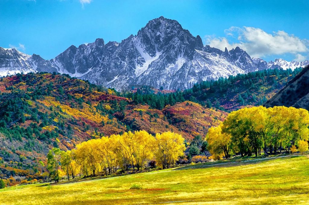
Mount Sneffels is a 14,155-foot Colorado fourteener in the San Juan Mountains near Ouray, using the LiDAR elevation listed by 14ers.com. See the mountain from Dallas Divide, hike nearby in Yankee Boy Basin or toward Blue Lakes, or climb the standard South Slopes route, an Easy Class 3 scramble with considerable exposure and rockfall potential. The standard climb ranges from 2.5 to 7.75 miles round trip depending on parking, so your vehicle and starting point matter almost as much as your fitness.
Some links on this page are affiliate links. We may earn a commission at no extra cost to you.
I would make one decision before booking anything: do you want to look at Mount Sneffels, walk beneath it, or stand on top? Those are three different trips, not three versions of the same easy outing.
This researched guide separates scenic stops, mountain hikes, and summit climbing. It is not a firsthand trip report or a substitute for navigation, mountaineering instruction, or current conditions.
Key takeaways
Mount Sneffels works as a scenic destination without committing to the summit. Climbers need a separate plan for rough-road access, scrambling, and changing mountain conditions.
- Dallas Divide is the scenic-view option; Blue Lakes and Yankee Boy Basin offer walking alternatives.
- The standard South Slopes route is Easy Class 3, not an ordinary walking trail.
- The commonly quoted six-mile climb starts at the outhouse parking area, not the lower 2WD parking.
- The upper trailhead requires a genuinely capable high-clearance 4WD vehicle and appropriate driving judgment.
- Blue Lakes permit proposals and existing wilderness restrictions are separate matters.
- Snow, thunderstorms, or an uncomfortable descent are reasons to change the plan, not push through it.
Route figures follow 14ers.com’s South Slopes guide; regulations follow the Forest Service wilderness order.
Should you see Mount Sneffels, hike nearby or climb it?
Choose Dallas Divide for a mountain view, Yankee Boy Basin or Blue Lakes for a hiking-focused visit, and the South Slopes only when your party is ready for scrambling. Mount Sneffels does not require a summit attempt to justify the journey.
See it: Dallas Divide
Choose the Dallas Divide area for the classic Sneffels Range panorama. Use legitimate public pullouts and respect private property.
Downside: clouds can hide the summit. This is a viewpoint outing, not close-up access to the climbing route.
Hike: basin or lakes
Choose a defined turnaround in Yankee Boy Basin, or research the separate Blue Lakes approach through East Dallas Creek.
Downside: “Not summiting” does not mean flat, short, or free of weather hazards. Blue Lakes also has specific management rules.
Climb: South Slopes
Choose the summit only with suitable fitness, scrambling ability, equipment, and conditions.
Downside: loose terrain and the exposed V-notch remain part of the route even when you start at the highest parking.
For hiking restrictions, consult the Forest Service’s Mount Sneffels Wilderness information. I would not treat Blue Lakes as a casual add-on to a Yankee Boy Basin climb: the approaches need separate planning.
How hard is the Mount Sneffels climb?
Mount Sneffels’ standard South Slopes route is rated Easy Class 3 by 14ers.com, with considerable exposure and rockfall potential. “Easy” describes its position within Class 3 scrambling, not an easy day for an inexperienced hiker.
The route includes loose slopes and a short hands-on passage through the V-notch near the summit. Exposure means a fall could have serious consequences; distance alone does not capture that risk.
I would want every person to be comfortable descending steep, loose terrain and reversing a scramble. Strong cardiovascular fitness cannot make up for freezing at an exposed move.
Use the photos and risk ratings in the complete South Slopes route description. For land-management restrictions, check the GMUG Forest Service alerts.
Who this is not for: someone seeking a maintained trail all the way to a fourteener summit. For a first scrambling peak, experienced instruction or a qualified local guide is a more sensible investment than simply choosing the shortest approach.
How long is Mount Sneffels from each parking area?
Mount Sneffels’ South Slopes climb is approximately 7.75, 6, or 2.5 miles round trip depending on the start. The matching elevation gains are 3,400, 2,900, and 1,700 feet, according to 14ers.com.
Lower 2WD parking
7.75 miles round trip; 3,400 feet of gain.
Near the Governor Basin junction described in the route guide. A conservative choice when continuing becomes unsuitable, not a guarantee that every passenger car can reach it.
Outhouse parking
6 miles round trip; 2,900 feet of gain.
Reached after the road becomes 4WD. This is the reference start behind the frequently repeated six-mile figure.
Upper trailhead
2.5 miles round trip; 1,700 feet of gain; approximately 12,460 feet elevation.
Requires high clearance, 4WD, and a suitable short wheelbase. It removes approach distance, not the summit difficulties.
These are route-planning figures, not surveyed promises for every parking space. Check official access alerts and the named start in your downloaded route before calculating timing.
Can a regular car reach Yankee Boy Basin?
A regular car should not be planned around reaching Mount Sneffels’ outhouse parking or upper trailhead. The published approach changes from a dirt-road drive to 4WD terrain before the outhouse.
From US 550 just south of Ouray, the approach begins on County Road 361, commonly called Camp Bird Road. The route description then follows CR 26 toward Yankee Boy Basin, with important junctions for Imogene Pass and Governor Basin.
14ers.com places the Governor Basin junction at roughly 6.7 miles from the initial turn and the outhouse around 7.5 miles. Beyond the outhouse, the road becomes substantially rougher. Treat mileages as navigation aids, not permission to keep driving.
My decision rule is simple: park legally before your vehicle or confidence runs out. All-wheel drive is not a substitute for clearance, appropriate tires, or experience on narrow mountain roads.
The cost trap is renting an SUV and assuming its contract allows this drive. Check the rental agreement, damage exclusions, and recovery arrangements before using a flight-and-hotel package as your complete transport plan.
Check Forest Service alerts and local road information before departure. Snow, washouts, or restrictions can invalidate an otherwise reasonable summer itinerary.
When is the best time to visit Mount Sneffels?
For a hiking-focused Mount Sneffels trip, aim for established summer conditions rather than a particular calendar date. The best summit window is when the approach is accessible, the route matches your skills, and the weather allows a safe descent.
- June: do not assume the upper gully is dry. Remaining snow can change the equipment and experience required.
- July and August: useful planning months for summer hiking, but verify lingering snow and thunderstorm forecasts.
- September: Consider an earlier start and a larger margin for cold, shortening daylight, and new snow.
- October and November: treat early-winter conditions as possible, not as an inconvenient extension of summer.
- December through May: plan around snow-covered access and winter mountaineering considerations, not summer mileage alone.
This is a planning framework, not a live conditions report. I cannot confirm today’s road opening, snowline, or gully condition from a seasonal description.
Check the National Weather Service forecast, Colorado Avalanche Information Center, and Forest Service alerts. CAIC, Colorado’s avalanche forecasting service, also offers avalanche-awareness education; an online introduction does not replace field training.
What does the South Slopes route involve?
The Mount Sneffels South Slopes route combines a basin approach, a loose climb to Lavender Col, and a steeper summit section containing the V-notch. This overview explains the sequence, not every navigational decision.
Approach through Yankee Boy Basin
Lower starts include walking the rough road toward the upper trailhead. Save energy and attention for the mountain rather than treating the road walk as a race.
Climb toward Lavender Col.
The approach gives way to loose, scree-covered terrain below Lavender Col, the saddle listed at approximately 13,560 feet. If this section already exceeds someone’s comfort, the terrain ahead is not a sensible test of determination.
Assess the upper gully and V-notch.
Above Lavender Col, the route enters a steeper gully before passing through the V-notch to the summit area. Snow can make this a different mountaineering problem from the dry scramble described in summer reports.
Plan the descent before climbing higher.
My preferred checkpoint question is: can everyone reverse the next section without relying on encouragement, luck, or an improvised rescue? A doubtful answer is enough to turn around.
Download and study the full route photographs and navigation information, then check official wilderness alerts. Do not use this article as your only route resource.
Do you need a permit, and which wilderness rules apply?
The Forest Service says Blue Lakes permits are not required before next year, while its existing wilderness order already restricts camping, group size, waste disposal, and dogs. A proposed reservation system is not the same as an active requirement
Check the official Blue Lakes management updates before reserving accommodation. Future permit timing, boundaries, and fees need a fresh check for your travel dates.
The operative Mount Sneffels Wilderness order and map distinguish the East Dallas Creek area from the remainder of the wilderness:
- East Dallas Creek overnight groups cannot exceed six people.
- The remainder of the restricted area has a 15-person group limit, with additional stock provisions.
- Camping at Middle and Upper Blue Lakes is prohibited.
- Elsewhere in the described East Dallas Creek area, camping is limited to two consecutive nights.
- Camping within 100 feet of National Forest System trails or water is prohibited.
- Campfires are prohibited in East Dallas Creek, above treeline and within the specified trail and water setbacks.
- East Dallas Creek visitors must pack out human waste using a purpose-designed containment system.
- Dogs must be leashed, controlled and prevented from disturbing people, wildlife or property.
The order also specifies food-storage requirements in East Dallas Creek, including certified bear-resistant containers and defined attended-use exceptions. Read the actual wording rather than assuming a normal food bag qualifies.
One useful source distinction: the management summary describes changes beginning May 31, while the signed order states June 1 as its effective date. For enforceable details, use the signed order and its map, then ask the Ouray Ranger District at (970) 240-5300 if your itinerary crosses an unclear boundary.
What are the main Mount Sneffels safety risks?
Mount Sneffels combines loose rock, exposure, altitude, changing weather and potentially steep snow. A short route can still place a party far from quick assistance.
For rockfall, wear a suitable climbing helmet, avoid dislodging stones and avoid lingering beneath other climbers in confined terrain. Do not let a crowded gully pressure you into an unsafe line.
For thunderstorms, plan to leave exposed terrain before storms develop. The National Weather Service states that no outdoor location is safe during a thunderstorm; a summit rock, overhang or tent is not safe shelter.
For snow, equipment is only useful when paired with practiced skills. The route guide recommends crampons and an ice axe when snow occupies the upper gully. If your group lacks the required skills, choose another objective.
For altitude and fatigue, build flexibility into the trip and do not make the summit a nonrefundable obligation. I would rather lose a reservation than let a booking dictate a mountain decision.
Check NWS lightning guidance and the CAIC forecast. Read our travel insurance guidance, then verify scrambling, altitude, rescue and evacuation coverage with your insurer.
Where should you stay for Mount Sneffels?
Ouray is the most direct base to consider for the published Yankee Boy Basin approach. Ridgway can suit a broader scenic itinerary, while Telluride should be treated as a separate base rather than assumed to offer equivalent trailhead access.
I would compare cancellation terms, parking and an early checkout before comparing decorative extras. Use Ouray accommodation searches or hotel listings, and verify the actual location on a map.
For families or longer stays, compare vacation rentals with hotel totals, including cleaning charges. Our hotel guides provide broader booking advice, not a verified shortlist of local properties.
Camping is not an automatic money-saving fallback: a space must be legal and available. Check the official wilderness information before planning a lakeside night.
How should you plan a Mount Sneffels trip?
Plan Mount Sneffels in this order: objective, conditions, access, route and reservations. Reversing that order can leave you defending a booking instead of choosing a sensible outing.
Choose the objective first
Choose Dallas Divide for viewing, a defined basin or lake hike for walking, and South Slopes for a prepared summit party.
Match transport to the real start
Choose the lower start if the upper road exceeds your vehicle’s capability. Build the extra walking distance into your forecast and daylight margins.
Prepare a compact departure checklist
- Offline route, map, photographs and backup navigation.
- Forecast, official alerts and relevant avalanche information.
- Helmet, suitable footwear, layers, waterproof protection and headlamp.
- Food, water, first-aid supplies and emergency communication plan.
- Snow equipment only with appropriate training and conditions assessment.
- Waste-containment supplies and compliant food storage where required.
- A turnaround decision agreed by everyone before departure.
Use the Forest Service alerts page as a final official check. For the wider itinerary, compare flight options and use our travel-planning guides without letting cheap fares force an unsuitable climbing date.
Which Mount Sneffels mistakes are easiest to avoid?
The most avoidable Mount Sneffels mistakes come from mismatched assumptions about mileage, vehicles and conditions. Fix those before buying more equipment.
- Calling it a six-mile hike without naming the start. Fix: save the parking-specific distance and elevation gain.
- Reading “Easy Class 3” as beginner-friendly walking. Fix: assess scrambling and downclimbing ability separately from fitness.
- Assuming an SUV can reach the upper trailhead. Fix: verify clearance, drivetrain, contract restrictions and road conditions.
- Treating proposed Blue Lakes permits as already active. Fix: consult the current Forest Service implementation page.
- Following an old map through a restoration closure. Fix: obey signs. The Forest Service reports a realigned Blue Lakes creek crossing, and app updates can lag.
- Leaving descent planning until the summit. Fix: reassess at Lavender Col and before committing to the upper scramble.
Frequently asked questions
These Mount Sneffels answers distinguish published route facts from conditions that need checking. For access and regulations, the Forest Service remains the primary authority.
How high is Mount Sneffels?
14ers.com lists Mount Sneffels at 14,155 feet using LiDAR elevation data. Older references can show different figures; identify the measurement source rather than combining incompatible numbers.
Is Mount Sneffels a good first fourteener?
Mount Sneffels is not my default recommendation for someone with no mountain or scrambling experience. Its standard route includes loose terrain, exposure and an Easy Class 3 summit passage.
How long does Mount Sneffels take?
There is no reliable universal duration for Mount Sneffels. Your start, acclimatization, scrambling speed, crowding and conditions determine timing; plan the descent and turnaround margin rather than copying a fast trip report.
Do you need 4WD for Mount Sneffels?
You need appropriate 4WD capability for the higher Yankee Boy Basin parking options. The upper trailhead requires high clearance and a suitable short-wheelbase vehicle; lower parking means a longer climb.
Can you see Mount Sneffels without hiking?
Yes. Dallas Divide offers a scenic view of Mount Sneffels and its surrounding range without a summit hike. Visibility depends on weather, and visitors should use legal public stopping places.
Are dogs allowed on Mount Sneffels?
The wilderness order requires dogs to be leashed and controlled, without disturbing wildlife, people or property. Legal access is not a recommendation to take a dog through the summit scramble; verify additional restrictions for your route.
Can you camp at Blue Lakes?
Camping is prohibited at Middle and Upper Blue Lakes under the wilderness order. Other East Dallas Creek camping remains subject to group limits, setbacks, a two-night limit and additional waste and food-storage rules.
Is Mount Sneffels a volcano?
Mount Sneffels is described as an intrusive igneous peak within the San Juan Mountains’ ancient volcanic region, not a volcanic cone. Magma-related rock and a volcano are not interchangeable descriptions.
Plan your trip: useful booking platforms
For Mount Sneffels, I would prioritize flexible bookings over a small saving. Start with our hotel guidance, cheap-flight planning advice and travel-planning resources; none replaces checking mountain access.
How this Mount Sneffels guide was checked
This Mount Sneffels guide uses the Forest Service for regulations and Blue Lakes implementation, 14ers.com for route ratings and starting-point statistics, the National Weather Service for lightning safety, and CAIC for avalanche resources.
The signed wilderness order takes precedence over a general tourism summary. A management proposal does not establish an active booking requirement, and a published route description does not confirm today’s snow or road conditions.
No firsthand ascent, interview or live road inspection is claimed. Before traveling, reopen the official links and confirm anything that could change your access, equipment or legal camping plan.
WakaAbuja aims to keep information accurate, but access, policies, conditions and availability change. Always verify official sources before traveling. This article is general travel information, not mountaineering instruction, a live safety assessment or a guarantee of access. Check that any travel insurance explicitly covers your planned activities.